
Acherkogel
| Acherkogel | ||
|---|---|---|
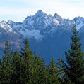
 Acherkogel from the northwest |
||
| height | 3007 m above sea level A. | |
| location | Umhausen , Silz, Oetz , Tyrol , Austria | |
| Mountains | Stubai Alps | |
| Dominance | 2.3 km → Hochreichkopf | |
| Notch height | 278 m ↓ Niederreichscharte | |
| Coordinates | 47 ° 11 '21 " N , 10 ° 57' 23" E | |
|
||
| rock | Granite gneiss | |
| First ascent | August 24, 1881 Ludwig Purtscheller , Franz Schnaiter | |
| Normal way | From Hochoetz over the Bielefelder Hütte and to the Mittertaler Scharte, further over the north flank ( II, mostly I ) | |
| particularities | Northernmost three-thousand meter mountains in Tyrol | |

The Acherkogel is 3007 m above sea level. A. high peak in the Stubai Alps and as such the most northerly three-thousand meter peak in Tyrol . It is the dominant summit above the village of Oetz in the anterior Ötztal with an altitude difference of 2200 meters. The deepest rock flanks extend down to the northwest and southwest. To the west, a sharp ridge leads to the Achplatte ( 2423 m ) and the Habicher Wand ( 2176 m ), another ridge goes north-east to the 2894 m high Maningkogel. To the southeast, the Acherkogel sends a sharp ridge to the 2954 m high Wechnerkogel. Essentially, the Acherkogel has the character of a rocky peak, only on the north and east side there are smaller firn fields .
The Acherkogel was climbed for the first time on August 24, 1881 by Ludwig Purtscheller . His companion Franz Schnaiter stayed behind on a step on the wall. However, the first person to climb found a stone surveying man on the summit, which probably came from the time the Franziszeische cadastre was created around 1854. This first survey of the country shows the surveying point on the side facing the village of Oetz, the so-called Signalkogel, on which the cross, first erected in 1956, is today. The actual main peak is a little further to the northeast. Presumably the term signal bird comes from this "measurement signal".
It also seems worth mentioning that on the Acherkogel the mountaineer greeting "Berg Heil!" should have been consolidated in its creation.
Topographic features
The imposing difference in altitude, which is 2200 meters from the bottom of the Ötzer valley to the summit visible from there, is a special feature of the mountain peaks of the Ötztal in another respect. In the neighboring town of Sautens , due to the special topography of this “rock monument”, an extraordinary sunrise can be experienced. The physical laws of the diffraction phenomena of light mean that in Sautens the beginning of spring and autumn is displayed in a corridor of less than 100 meters.
Paths to the summit
- The north flank ( UIAA II ) was first walked by Otto Melzer in 1893 and is now considered a normal route . The Bielefelder Hütte usually serves as a base .
- The northeast ridge ( UIAA IV , K. Holzhammer, 1924) leads from the saddle between Acherkogel and Maningkogel to the summit and is considered the most beautiful ascent. Most of the time, the Maningkogel is crossed when coming from Mittertal. The starting point for this route is usually the Kühtai or the Mittergrathütte .
- The south ridge ( UIAA II , F. Hörtnagl / H. Schmotzer, 1899) is mostly walked from the Dortmunder Hütte . The path of the first climbers, which is no longer used today, also runs close to this route.
- The south-west flank ( UIAA II , F. Gstrein / F. Lantschner / M. Pfaundler 1891) used to be considered the normal route, but is less used today.
Other rather insignificant increases are
- the southeast face ( UIAA V- , P. Schillfahrt / N. Raich, 1975),
- the west ridge ( UIAA III , F. Lantschner, 1893) and
- the northwest wall to the west ridge (F. Lantschner, 1921)
From left to right: Maningkogel, Acherkogel and Wechnerkogel (from the north-west)

Acherkogel from the Hinteren Karlesspitze (from the northeast)


literature
- Heinrich and Walter Klier : Alpine Club Guide Stubai Alps . 9th edition. Bergverlag Rudolf Rother, Munich 1980, ISBN 3-7633-1212-9 .
Web links
Remarks
- ↑ Only in the Salzburg part of the Glockner Group are elevations over 3000 m further north in Europe. The northernmost summit in Europe, which in the sense of the UIAA definition has the necessary notch height of 30 meters for an independent summit , is the Bauernbrachkopf .
- ↑ Clem Clements, Jonathan de Ferranti, Eberhard Jurgalski , Mark Trengove: The 3000 m SUMMITS of AUSTRIA - 242 peaks with at least 150 m of prominence , October 2011, p. 11.
- ↑ Ludwig Purtscheller: About rock and firn , edited by Heinrich Hess, Bruckmann Munich 1901, p. 41 ff.
- ↑ Bernhard Stecher: wöll töll completely - the myth of the Ötztal . Oetz 2017, ISBN 978-3-200-05132-4 , pp. 250-265 .
- ↑ Anniversary on the northernmost 3000 meter . In: Tiroler Tageszeitung Online . ( tt.com [accessed April 1, 2018]).
- ↑ Bernhard Stecher: wöll töll completely . 1st edition. Oetz 2017, ISBN 978-3-200-05132-4 , pp. 207 .
- ↑ Bernhard Stecher: wöll töll total - Mythos Ötztal , edited by Bernhard Stecher, agency bp10 2017, pp. 158–160.
- ↑ bergstieg.com : Maningkogel / Acherkogel NO ridge