
Mieming
|
Mieming
|
||
|---|---|---|
| coat of arms | Austria map | |
 |
|
|
| Basic data | ||
| Country: | Austria | |
| State : | Tyrol | |
| Political District : | Imst | |
| License plate : | IN THE | |
| Main town : | Obermieming | |
| Surface: | 50.34 km² | |
| Coordinates : | 47 ° 18 ′ N , 10 ° 59 ′ E | |
| Height : | 864 m above sea level A. | |
| Residents : | 3,790 (January 1, 2020) | |
| Population density : | 75 inhabitants per km² | |
| Postal code : | 6414 | |
| Area code : | 0 52 64 | |
| Community code : | 7 02 09 | |
| NUTS region | AT334 | |
| UN / LOCODE | AT MEM | |
| Address of the municipal administration: |
Obermieming 175 6414 Mieming |
|
| Website: | ||
| politics | ||
| Mayor : | Franz Dengg (Together for Mieming - Dr. Franz Dengg) | |
|
Municipal Council : (2010) (15 members) |
||
| Location of Mieming in the Imst district | ||
  |
||
| Source: Municipal data from Statistics Austria | ||


Mieming (local pronunciation: "Miaming") is a municipality with 3790 inhabitants (as of January 1, 2020) in the Imst district ( Silz judicial district ) in the state of Tyrol in Austria .
geography
Mieming is located in the middle of the Mieming Plateau above the Oberinntal , at the foot of the Mieming Mountains . The municipal area also includes a small part of the Gaistal , which branches off from Leutasch and is already behind the Mieming chain. The southern municipality boundary runs in the middle of the Inn .
Due to the climatically favorable location, which is also very sunny in winter, the comparatively low foehn influence, the proximity to the market town of Telfs and the good connection to the A12 Inntal autobahn , Mieming is experiencing significant settlement growth; the districts of Barwies and Obermieming have practically grown together, and the settlements in Weidach and Untermieming are developing dynamically. Above all, more and more young couples are moving in who commute to Innsbruck.
Localities
The municipality includes the following four localities (population in brackets as of January 1, 2020) with the associated localities:
|
|
Neighboring communities
history
The beginning of the settlement of the region in which Mieming is today goes back to the year 15 BC. BC back when the Romans conquered the Inn Valley and its province. Rätien zuteilten. Traces of this settlement are missing to this day, even if it can be assumed that some people settled here. It can also be assumed that there was a connection between the Via Claudia Augusta , a path over the Fernpass to Augsburg and the road from Veldidena via Scharnitz to Augsburg, which led via today's Mieming.
After the end of the Roman Empire in AD 476, Tyrol became part of the Visigothic Empire and the Bavarians immigrated peacefully into the settlement area. Even if the exact time of settlement by the Bavarians is not certain, it remains certain that Mieming is definitely one of the old Bavarian settlement areas.
In 1071 "Mieminga" was mentioned for the first time among other goods in the endowment list of the Augsburg Collegiate Foundation St. Gertrud .
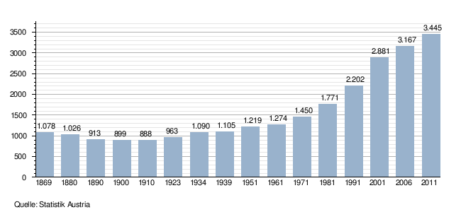
Population development
Culture and sights
- Barwies parish church in Barwies
- Untermieming parish church in Untermieming
- Branch church Obermieming in Obermieming
- Stamser footbridge
Economy and Infrastructure
In addition to agriculture, tourism is also important, with a focus on the summer season.
Leisure and Tourism
Mieming offers a wide range of sports and cultural activities. Not only are there a large number of hiking trails, but bike tours can also be started from here. There are other offers in the area of riding, motorcycles, climbing, water sports and much more. There is a 27-hole golf course. On September 12, 2018, the Mieming City Council voted unanimously to actively support the FC Wacker Innsbruck training center in order to minimize the FCW's lack of space.
politics
coat of arms
Blazon : A branch of juniper in a split white-red shield in the white field.
The municipal coat of arms, awarded in 1953, shows the Tyrolean state colors in white and red. The juniper branch indicates that this plant is widespread in the Mieming area, which is already mentioned in the Tyrolean rhyme of 1558.
Town twinning
- Limas : commune in the Rhône department in the Auvergne-Rhône-Alpes region .
Personalities
Sons and daughters of the church
- Reinhard Neuner (* 1969), biathlete
Personalities associated with the community
- Uli Brée (* 1964), screenwriter, director and actor
- Markus Kniepeiß (* 1982), illusion painter and restorer
- Ann-Kathrin Kramer (* 1966), actress and author
- Harald Krassnitzer (* 1960), actor and presenter
- Ernst Schroffenegger (1905–1994), painter
- Eduard Wallnöfer (1913–1989), Governor of Tyrol 1963–1987
- Andreas Widhölzl (* 1976), ski jumper, ski jumping trainer
Web links
- Website of the municipality of Mieming
- 70209 - Mieming. Community data, Statistics Austria .
Individual evidence
- ↑ Statistics Austria: Population on January 1st, 2020 by locality (area status on January 1st, 2020) , ( CSV )
- ↑ Mieming community: About the settlement of our area (PDF; 95 kB)
- ↑ Martin Bitschnau , Hannes Obermair : Tiroler Urkundenbuch, II. Department: The documents on the history of the Inn, Eisack and Pustertal valleys. Vol. 1: Up to the year 1140 . Universitätsverlag Wagner, Innsbruck 2009, ISBN 978-3-7030-0469-8 , p. 216, no.243 .
- ↑ Golfpark Mieminger Plateau ( Memento of the original from January 27, 2017 in the Internet Archive ) Info: The archive link was inserted automatically and has not yet been checked. Please check the original and archive link according to the instructions and then remove this notice.
- ↑ FCW communication: FC Wacker Innsbruck - Mieming municipal council unanimously for the "FCW training center" project. Retrieved October 28, 2018 (German).
- ↑ Provincial Law Gazette for Tyrol No. 18/1953 ( digitized version )
- ^ Eduard Widmoser: Tiroler Wappenfibel . Tyrolia-Verlag, Innsbruck 1978, ISBN 3-7022-1324-4 , p. 11 .
Arzl im Pitztal | Haiming | Imst | Imsterberg | Jerzens | Karres | Karrösten | Längenfeld | Mieming | Mils at Imst | Mötz | Nassereith | Obsteig | Oetz | Rietz | Roppen | St. Leonhard im Pitztal | Sautens | Silz | Sölden | Stams | Tarrenz | Umhausen | If it