Mieminger Mountains
| Mieming chain
Mieminger Mountains
|
|
|---|---|
|
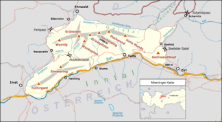
Overview map of the mountain range |
|
|
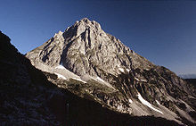
North view of the Mieminger Mountains with Ehrwalder Sonnenspitze |
|
| Highest peak | High plateau ( 2768 m above sea level ) |
| location | Tyrol , Austria |
| part of | Northern Limestone Alps |
| Classification according to |
AVE : 4 (Wetterstein Mountains and Mieminger Chain) SOIUSA : 21.III.A |
| Coordinates | 47 ° 21 ′ N , 10 ° 59 ′ E |
|
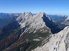
Wetterstein Mountains and Mieming Range (left) from the northeast |
|
The Mieminger Gebirge (also called Miemingerkette ) is a mountain group of the Northern Limestone Alps in the Eastern Alps . It is located entirely in Austria in the state of Tyrol . The sub-group is somewhat in the shadow of the more famous Wetterstein directly to the north , with which it forms the AVE group 4 Wetterstein Mountains and Mieminger Chain . While the area around Coburger Hütte, Seeben- and Drachensee in the west (Ehrwalder Sonnenspitze and Vorderer Tajakopf with via ferrata over the Tajakante) and the Hohe Munde in the far east receive lively visitors, the poorly developed central section has remained very quiet. The Hohe Munde is also a popular, demanding ski tour destination.
Public transport connections: The Ausserfernbahn stops in Ehrwald on the west side of the mountains . After Leutasch on the south side buses run from Mittenwald and Seefeld in Tirol .
Geological conditions
The Mieming Mountains are located in a geologically particularly interesting area. Between Sonnenspitze, Wetterstein and Daniel, three stone units meet, which were stacked on top of each other in the course of the mountain formation and are now open close to each other. The Mieming Mountains lie in one of these nappes: the Inntal nappa. Almost all of the rocks in the Mieminger Mountains originated on the seabed and consist of limestone and its transformation product, dolomite . In addition, there are sandstones , claystones , chert stones , rough chops and volcanic tuffs .
In relation to the total age of the earth, which is around 4500 million years, the rocks in the Mieming Mountains essentially come from two relatively small time windows. One of them began about 250 and ended 130 million years ago (Mesozoic with the Triassic and Jurassic ages ) while the other covers the last 10,000 years since the end of the Worm Ice Age (part of the New Earth Age). Older rocks exist in Zwischentoren nowhere and younger were removed since the Alps form approximately 35 million years of wind, weather and water.
First of all, the geological history begins in the tropical climatic area, on the edge of an extensive flat sea, the Tethys Ocean. This is where material is initially deposited that was washed into the sea from the land until the sea level rises and calcifying organisms begin to colonize. Sea deposits of limestones, dolomite stones, Rauhwacken and breccias, some of which still indicate land proximity, are exposed in a narrow strip between Langlehn and Igelskar (Reichenhall layers). Since they weather relatively easily, they form gaps and törles, such as the Biberwierer Scharte or the Tajatörl.
In the next period of time, a mighty sequence of dark limestones emerges, which often smell slightly of bitumen when they are chipped and which stand out due to their uneven, sausage-like layer surfaces: Alpine Muschelkalk. In these limestones there are irregularly formed, dark brown to black chert crooks and greenish tuffs, which indicate nearby volcanoes similar to Stromboli. This sequence comes from a shallow, oxygen-rich sea area in which reefs and basins alternate with one another. Later on, the Partnach layers form , which can be seen particularly beautifully in the "blackness" between Marienbergspitzen and Wampertem Schrofen. They consist of light limestone banks and clay stones in between.
Then the reef begins to develop in the shallow sea water, where small calcareous algae and corals live. Their dead, calcareous skeletons build the most important rocks: the Wetterstein limestone. This mostly bright white and weather-resistant limestone clearly stands out from the other rocks. It forms the distinctive peaks of the Mieminger and Wetterstein mountains. The Sonnenspitze, Hedgehog and the Zugspitze are made of this rock. Since the Wetterstein limestone contains only a few plant nutrients, its debris heaps are mostly not overgrown and thus characterize the landscape above the tree line.
Silver-containing lead and zinc ores are a specialty of Wetterstein limestone. They were mined on the Silberleithe and in the rest of the Mieminger Mountains. With the Wetterstein Limestone, the Triassic era ends in the Mieminger Mountains and the Jura begins, the deposits of which are of subordinate importance. They have been largely removed over the course of millions of years and are only preserved in a few protected places and underground.
At the time of their deposition, the rocks of the Northern Limestone Alps were a few hundred kilometers south of their current position. Extreme forces, which are still at work today, began to push these rock units north about 35 million years ago. At that time there were a few kilometers of rock and a few hundred meters of water above the rocks that are visible today. As a result, there was a large overburden pressure that prevented the formations below from breaking apart when they were pushed together.
To avoid the pressure, folds formed in the rocks, some of which tore apart and piled up to form rock ceilings. For example, the steep drop from the Mieminger Mountains into the Ehrwald Basin or the Leutasch is the front of such a pile, which is known as the Inn Valley ceiling. At the same time, the rocks were pressed out upwards. Collectively, these processes are referred to as mountain building.
The relatively young deposits in the up to 70 meters deep moss are mainly gravel, gravel, loam, humus and peat, which at Lermoos was even supposed to be used once for the lead-zinc smelter of the Silberleithen union. The mountains and valleys received the finishing touches in the Würm Ice Age . The ice of the Loisach glacier stood about 1000 meters high and after the ice thawed about 10,000 years ago, the glacier left behind the typical ice age terrain: the moraines. The remaining ice in the mountains formed the typical cirque, in which the last moraines of the glaciers are preserved.
The most decisive change in the landscape after the last ice age caused the fall of the Fern Passberg. He buried the valley between Biberwier and Nassereith 200 meters high. The landscape has changed little since then. Occasionally there are debris avalanches, rock falls or falls from the Mur. Water, ice and wind continue to attack the rocks, transporting their debris over the torrents down into the valley and remind us that the geological processes continue to this day.
Neighboring mountain groups

The Mieming chain borders the following other mountain groups in the Alps:
- Stubai Alps (in the south)
- Ötztal Alps (in the southwest)
- Lechtal Alps (in the west)
- Wetterstein (in the north)
- Karwendel (in the east)
In the AVE , the Alpine Association classification of the Eastern Alps , published in 1984, the Mieminger chain and the Wetterstein Mountains are represented as a single mountain group.
Boundary
In the south, the Inn forms the border from the confluence of the Niederbach in Dirschenbach near Inzing upstream to the confluence of the Gurglbach near Imst . The border in the west runs along the Gurgltal from Imst to Nassereith and over the Fernpass to Ehrwald . In the north, the border runs from Ehrwald along the Gaisbach and the Ehrwalder Alm to the Gaistal ( Leutascher Ache ) and further via Leutasch –Oberweidach and north of the Simmelberg along the Bodenbach to the Drahnbach. The border in the east runs along the Drahnbach and over the Seefelder Sattel , then downwards along the Niederbach to the confluence with the Inn.
The Fernpass connects the Mieming chain with the Lechtal Alps. The unnamed saddle at Ehrwalder Alm creates the connection between the Mieminger chain and Wetterstein. The Seefeld plateau connects the Mieming chain with the Karwendel.
Subgroups
According to the Alpine Club Guide
The alpine club leader divides the Mieming chain into the following subgroups:
- Main ridge (from the Hohe Munde to the Hochwannig)
- Northern side ridges (Wampeter Schrofen, Schartenkopf, Sonnenspitze, Breitenkopf, hedgehog heads, tajak heads, dragon heads)
- Southern side ridges (Hintereggenkamm, Judenkopfkamm, Schlosskopfkamm, Wankspitzen, Arzbergkamm, Höllkopf)
- Tschirgant-Simmering-Stock (Tschirgant, Simmering)
- The hill country between Seefeld and the Buchener Sattel near the Hohe Munde is not described in the Alpine Club Guide. Orographically, however, it undoubtedly belongs to the Mieming chain.
According to SOIUSA
According to SOIUSA, the Mieming chain is divided into three groups and four subgroups.
- Mieming chain (in the narrower sense) (A.1)
- Grünstein-Marienbergspitze-Kamm (A.1.a)
- Semolina high plateau comb
- Tschirgant-Simmering-Massif (A.2)
- Seefeld Mountains (A.3)
- Hochmoos-Simmlberg-Kamm (A.3.a)
- Harness stick (A.3.b)
The Mieming chain is itself a sub-group of the main group "Mieming chain and Wetterstein mountains".
summit

The 10 highest peaks of the Mieming chain:
- Hochplattig , main summit, 2768 m
- Hochplattig, Westeck, 2749 m
- Eastern Griesspitzen, 2747 m
- Western Griesspitzen, 2741 m
- Hochwand , northeast summit, 2719 m
- Hochwand, southwest summit, 2715 m
- Eastern Mitterspitze, 2705 m
- High plateau, signal summit, 2698 m
- West Mitterspitze, 2693 m
- Middle Mitterspitze, 2686 m
Are in the Mieminger chain 60 named and with spot elevation provided Summit. The better known include, in order of height:
- Grünstein , 2666 m
- Hohe Munde , 2659 m
- Wannig , 2493 m
- Front tayak head , 2452 m
- Ehrwalder Sonnenspitze , 2417 m
- Rear tayak head , 2409 m
- Tschirgant , 2370 m
- Simmering , 2096 m
There is a ski area in the area of the 1789 m high Marienbergjoch.
tourism
Huts
There are three Alpine Club huts in the Mieminger chain, only one of which is managed:
- Alplhaus : Height 1506 m, self-catering (special lock ), not managed, keys available from the DAV section Munich , 16 mattress dormitories, valley town Wildermieming, walking time from Wildermieming: 2 hours
- Breitenkopfhütte : altitude 2040 m, self-catering (AV key), not managed, 5 mattress dormitories, Ehrwald valley, walking time from Ehrwald: 3.5 hours
- Coburger Hütte : altitude 1920 m, open from the beginning of June to October, 80 mattress dormitories, winter room with 10 dormitories, valley town Ehrwald, walking time from Ehrwalder Alm (cable car): 2 hours
Long-distance / long-distance hiking trails
The Via Alpina , a cross-border long-distance hiking trail with five partial trails through the entire Alps, also runs through the Mieming Mountains.
The Red Path of Via Alpina runs in two stages through the Mieming Mountains as follows:
- Stage R46 runs from the Reintalangerhütte to the Coburger Hütte. The first part of this stage is in the Wetterstein.
- Stage R47 runs from the Coburger Hütte via Biberwier to the Wolfratshauser Hütte. The second part of this stage is in the Lechtal Alps.
Literature and maps
- Rudolf Wutscher: Mieminger chain. A guide for valleys, huts and mountains (= Alpine Club Guide . Eastern Alps ). Bergverlag Rother, Munich 1989, ISBN 3-7633-1099-1
- Alpine Club cards 1: 25,000, pages 4/1, 4/2, 4/3, Wetterstein and Mieminger Mountains West / Middle / East


