Seefeld saddle
| Seefeld saddle | |||
|---|---|---|---|
|
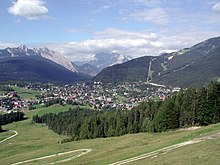
View from the northwest on the Seefelder Sattel with the Wildsee , in the background the Kalkkögel |
|||
| Compass direction | south | North | |
| Pass height | 1185 m above sea level A. | ||
| state | Tyrol ( Austria ) | ||
| Watershed | Mühlbach, Niederbach, Inn |
Seebach, Drahnbach, Gießenbach, Isar |
|
| Valley locations | Zirl | Mittenwald | |
| expansion | Pass road: |
||
| Mountains | Karwendel | ||
| profile | |||
| Denzel scale | SG 3 | SG 2 | |
| Ø pitch | 5.2% (563 m / 10.9 km) | 2.6% (221 m / 8.6 km) | |
| Max. Incline | 16% | 7.3% | |
| Map (Tyrol) | |||
|
|
|||
| Coordinates | 47 ° 19 '5 " N , 11 ° 11' 50" E | ||

The Seefelder Sattel is 1185 m above sea level. A. high mountain saddle and mountain pass in the Northern Limestone Alps in the Austrian state of Tyrol . The Seefelder Straße (B 177) and the Mittenwaldbahn are the main traffic routes over it, and Seefeld in Tirol ( 1180 m ) is located on the Seefeld plateau north of the saddle .
geography
location
The Seefelder Sattel is west of the Erlspitz group (max. 2405 m ), a foothill of the Karwendel , and east of the Mieminger Mountains (max. 2768 m ). To the south it goes over the Zirler Berg down to the Inntal , in the north of the plateau are the Wetterstein Mountains (max. 2962 m ) and the Arnspitz group (max. 2196 m ). The actual top of the pass is located near the municipal boundary between Seefeld and Reith, bordering to the south, in its Auland district in an agricultural area southeast of the Wildsee or north-northwest of the junction of Landesstraße 36 from Seefelder Straße (B 177). To the east of the saddle rise the Reither Spitze ( 2374 m ) with the Seefelder Spitze ( 2221 m ) to the north, and the Gschwandtkopf ( 1495 m ) to the west .
Watershed
The Seefelder Sattel is located on the watershed between the Inn and the Isar . While the water of the Mühlbach, which rises northeast of Auland, flows southward through the Niederbach into the Danube tributary Inn, that of Raabach and Haglbach runs through the Seebach (flowing from the Wildsee) and Drahnbach and Gießenbach northeastward into the Danube tributary Isar.
traffic
Street
The Seefelder Straße (B 177) leads over the Seefelder Sattel . It runs from the southeast in Inntal lying Zirl (with connection to Innsbruck via the A12 or B 171 ) on the south and east face of Zirler Bergs (with there up to 16% gradient) by Reith and Seefeld and then the northeast to at Isar located Scharnitz on the Austrian-German border and there passes the Scharnitz Pass , from where it continues in Germany as Bundesstrasse 2 in Germany past Mittenwald via Garmisch-Partenkirchen to Gartz (Oder) . As part of the eastern Seefeld bypass, the road north of the saddle near the Seefeld-Mitte junction reaches a little more than 1,220 m in height. At the Auland south of the saddle, the state road 36 branches off, which leads through Seefeld to Telfs in the Inn Valley.
railroad
A section of the winding and tunnel-rich Karwendelbahn , the railway line leading from Innsbruck via Seefeld and Mittenwald to Garmisch-Partenkirchen, runs roughly parallel to Seefelder Straße over the Seefelder Sattel - with train stations and stops in Reith, Seefeld and Scharnitz, among others.
history
The route over the Brenner Pass and the Seefelder Saddle was already important as a trade route in pre-Roman times , among other things as one of the Amber Roads . After the conquest of the foothills of the Alps by Drusus and Tiberius in 15 BC. Chr. Was the burner ( via Alpes Norias ) a cart path created or used further. Under Septimius Severus , the connecting road to Veldidena (now Innsbruck - Wilten ), known today as Via Raetia, was paved as a Roman road and continued over the Seefelder Sattel and through the Scharnitz Pass to Augusta Vindelicorum ( Augsburg ).
In contrast to the Seefelder Sattel, the Scharnitzpass is not a mountain pass, but rather a valley pass , i.e. the narrowing of a rocky gorge. The Isar valley near Scharnitz, narrowed by the foothills of the Arnspitz group , could give travelers the impression of a gate (lat. Porta ) compared to the widening valley floor towards Mittenwald and Seefeld.
To secure their road, the Romans built the Mansio Scarbia settlement on the Scharnitz Pass , from which the name Scharnitz comes. The importance of the route over the Seefelder Sattel and through the Scharnitz Pass is also borne out by the discovery of a Roman milestone near Partenkirchen , and the two most famous Roman road maps Itinerarium Antonini and Tabula Peutingeriana name this route as a first-order military and trade route. This street was very busy and was probably built as a passable street. Remains of this Roman road are in Klais to see one there as a ravine scale of road has been preserved along with carved grooves track today.
the valley on the right leads to the Zirler Berg on the Inn valley , the one on the left to the Scharnitzpass on the Isar
Individual evidence
- ↑ Rupert Breitwieser, Andreas Lippert : Pass routes of the Celtic and Roman times in the Eastern Alps . In: Mitteilungen der Anthropologische Gesellschaft in Wien , 129 (1999), p. 127.
- ^ Steffan Bruns: Alpine passes. The passes on both sides of the Brenner route . tape 1 . L. Staackmann Verlag, Munich 2010, ISBN 978-3-88675-256-0 , p. 57 .


