Flattnitz
| Flattnitz | |||
|---|---|---|---|
|
Lake with reeds in Flattnitz |
|||
| Compass direction | north | south | |
| Pass height | 1400 m above sea level A. | ||
| state | Carinthia | ||
| Watershed | Flattnitzbach, Paalbach, Mur , Drau , Danube | Jauernigbach, Glödnitzbach, Gurk , Drau, Danube | |
| Valley locations | Stadl an der Mur | Weissberg | |
| expansion | Pass road | ||
| Mountains | Gurktal Alps | ||
| profile | |||
| Ø pitch | 6.8% (615 m / 9.1 km) | ||
| Max. Incline | 15.0% (on km 9) | ||
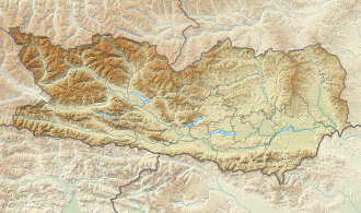
| Map (Carinthia) | |||
|
|
|||
| Coordinates | 46 ° 56 '45 " N , 14 ° 1' 45" E | ||

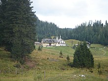
The Flattnitz is a health resort in Carinthia belonging to the municipality of Glödnitz . It is located on a high level of Gurktaler Alps that a transition between the Gurk- and the Mur forms. On the Styrian side, the pass road ends in Stadl an der Mur . The top of the pass, called Flattnitzer Höhe, is 1400 m above sea level. A. , a small lake nearby, the Flattnitzer See .
The name "Flattnitz" comes from the stream of the same name that flows through the town in the direction of the Mur . It can be traced back to blato (Slov.: Moss). Worth seeing is the Romanesque church, which stems from the earlier importance of hauliers and mining (see also mining in Carinthia ).
The valley head of the Paalbach zur Flattnitz, which adjoins to the west, is also commonly counted, which belongs to the municipality of Deutsch-Griffen , but is not accessible from there.
history
The Tabula Peutingeriana mentions a supply station called Tarnasicis , which today is suspected on the basis of the miles given in relation to Immurium on the Flattnitz.
The area around Flattnitz is first mentioned around 898 in a deed of donation from Emperor Arnulf to the noble Zwentibold. The silver, iron and lead deposits were of great economic importance. The Flattnitz served the Gurk bishops as a summer residence, Bishop Heinrich I had the round church of St. John the Baptist built in 1173. In 1478 the Turks invaded and made the Flattnitz the "Bloody Alm". The alpine region of the Flattnitzer Saddle is visited today by summer and winter vacationers alike.
At the end of the 18th century, a well-known competition was held on June 24th, St. John's Day and the second Sunday afterwards . The male youth from Carinthia, the nearby Salzburg and Styria gathered. A legendary winner over seven years at this time was Johann Strauss, the "Magdaleniger Hansl" from St. Jakob ob Gurk .
Attractions
church
Only a few remains of the Romanesque chapel from the second half of the 12th century have been preserved in today's masonry. The early Gothic rotunda was built around 1330 with a main choir, two polygonal side apses and a fortified sacristy tower. The relatively low, massive tower with a pyramid helmet is decisive for the exterior view. Together with the former hospice extension in the west, the church forms a picturesque assembly. The entire building ensemble is covered with gray stone slabs.
17th century lime kiln
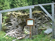
Since the Flattnitz was heavily influenced by mining around the 17th century , there is still a lime kiln from this time at this location (administratively, however, already in the municipality of Deutsch-Griffen ) . This was used to produce masonry lime. This stone lime kiln is well worth seeing because of its good preservation.
Office building
The official or toll house is not far from the church above the main road ⊙ . It is one of the oldest offices in Austria and is probably the oldest in Carinthia. The house, which was built partly with rubble stones and partly as a log building, has a full walled roof covered with wooden shingles . The building is a listed building .
Residents
The Flattnitz is a scattered settlement with around 200 inhabitants. The residents mainly work in year-round tourism and in alpine farming .
tourism
There are three ski lifts and various slopes of various levels of difficulty, as well as a 15-kilometer cross-country ski run. There are also many natural hiking trails in Flattnitz and the surrounding area.
climate
|
Average monthly temperatures and precipitation for Flattnitz
|
|||||||||||||||||||||||||||||||||||||||||||||||||||||||||||||||||||||||||||||||||||||||||||||||||||||||||||||||||||||||||||||||||||||||||||||||||||||||||||||||||||||||||||||||||||||||||||||||||||
Web links
Individual evidence
- ^ ÖK 50 www.austrianmap.at , Federal Office for Metrology and Surveying Austria, Austrian map.
- ^ The Romans, Slavs and Bavarians in Tamsweg im Lungau - The Tamsweg Tourist Office in Salzburg's Lungau. In: tamsweg.info. Accessed December 31, 2017 .
- ↑ Flattnitz. In: flattnitz.net. Accessed December 31, 2017 .
- ^ Joseph Mitterdorfer: Journey from the Gurkthal in Carinthia to the Flatnizer Alpe and to the great Eisenhut in Steyermark. In: Vaterländische Blätter for the Austrian Imperial State , October 4, 1815, p. 1 (online at ANNO ).
- ↑ Joseph Mitterdorfer: The competition on the Flatnizer Alps in Carinthia. In: Carinthia . 5th year, no. 17 . Verlag des Geschichtsverein für Kärnten, Klagenfurt 1815 ( ÖNB digital p. 89 ff. ).
- ^ Dehio manual. The art monuments of Austria. Carinthia . Anton Schroll, Vienna 2001, ISBN 3-7031-0712-X , p. 142.


