
Radstadt Tauern Pass
| Radstadt Tauern Pass | |||
|---|---|---|---|
 Pass height in Obertauern |
|||
| Compass direction | North | south | |
| Pass height | 1738 m above sea level A. | ||
| state | Salzburg , Austria | ||
| Watershed | Northern Taurach , Enns , Danube | Southern Taurach , Mur , Danube | |
| Valley locations | Radstadt | Mauterndorf | |
| expansion | Katschbergstrasse (B99) | ||
| Mountains | Schladminger / Radstädter Tauern | ||
| particularities | Altstrasse | ||
| profile | |||
| Ø pitch | 4.2% (880 m / 21 km) | 3.6% (615 m / 17.3 km) | |
| map | |||
|
|||
| Coordinates | 47 ° 14 '53 " N , 13 ° 33' 33" E | ||

The Radstädter Tauernpass , officially Radstädter Tauern , is 1738 m above sea level. A. high mountain pass between two mountain groups of the Niedere Tauern , the Schladminger Tauern in the east and the Radstädter Tauern in the west. The pass is located in the state of Salzburg in Austria and connects the Pongau and Lungau in the Taurach Valley .
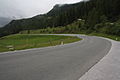
Today's Katschbergstrasse (B99), which leads from Radstadt im Ennstal over the pass to Tweng and Mauterndorf im Lungau and finally over Sankt Michael im Lungau and the Katschbergpass ( 1641 m above sea level ) to Carinthia , leads over this alpine crossing , which was already used in antiquity . The winter sports resort of Obertauern is right on the pass .
The two rivers, the Northern Taurach (Pongauer Taurach) and the Southern Taurach (Lungauer Taurach), both of which run parallel to Katschbergstrasse in parts, arise near the top of the pass . Katschbergstraße and the respective Taurach cross a narrow point in both ramps. In the north ramp is the very narrow Taurachklamm, in the south ramp the Twenger Talpass .
Surname
The pass is named after the town of Radstadt im Ennstal , while the pass is named after the mountain range of the Radstädter Tauern.
history
Already in pre-Roman times the Taurisker built a road over the Radstädter Tauern, which was probably already passable in Norian times. The finished road used by the Romans later developed into one of the most important Alpine roads of all after extensive extensions and modernizations had been carried out in some cases. Over the years, however, the road fell into disrepair, so that ore transport almost came to a standstill.
The Römerstraße and the In Alpe station
An extensive renovation of the Radstadt Tauern Pass Road took place in the Roman Empire under Septimius Severus (193–211). The former governor of Rome in Pannonia and later emperor built several Alpine roads. The new route of the Tauriskerstrasse led largely on the stretch of the old street. The section that was re-routed, especially near the pass, even resulted in a shortening of the old route. The Roman road Virunum - Iuvavum was built as a military road of the first order in order to create a quick connection with Italy during the constant defensive battles of the Roman legions on the northern border .
With the help of bends, the Roman road builders mastered a height difference of 725 meters with an average gradient of 8.25%. Some researchers see a mule track in the road, which is only 2.5 meters wide ; however, it is likely that it was passable with carts along its entire length, including over the top of the pass. Large stone slabs formed the road surface, high delimitation stones delimited the road, where a slope of the carriageway ensured water drainage.
The pass of the Radstädter Tauern is entered in the Roman street maps under the name In Alpe ; a name that in late antiquity referred to at least the Roman mansio (post and horse changing station) in the immediate vicinity of the pass. Here was mile point 16 (XVI) of the road. The location at the Tauern cemetery is believed to have been found here as early as 1825, but the finds (tools, weapons, coins) have been lost.
Several Roman milestones made of Schaidberger marble have been preserved as milestones of the renovation on both pass ramps . Six stones from the 3rd century, originally from the Moaralm , are at the Tauern cemetery. Two Roman stones can still be found on the Twenger Talpass (Wacht) to the south. Stones from Posthaus Tweng are deposited in Salzburg. A total of five milestones were found south of the Tauern Pass.
photos
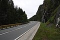
North ramp

South ramp

the Lungauer Taurach between the Twenger Valley Pass and the Radstädter Tauern Pass
Twenger valley pass

Roman milestone of Emperor L. Septimius Severus (193–211) on the south ramp


Web links
Individual evidence
- ↑ Radstädter Tauern and the surrounding area on ÖK 50 , www.austrianmap.at , Federal Office for Metrology and Surveying Austria, Austrian map.
- ↑ Steffan Bruns: Alpine passes - from the mule track to the base tunnel , vol. 4, p. OA
- ^ Tauern cemetery . In: Salzburger Nachrichten : Salzburgwiki ..
- ^ A b Ignaz von Kürsinger : Lungau. Oberersche Buchhandlung 1853, Die Roman Mansio , p. 58 ff and Chapter IV Tweng und die Römersteine , p. 87 ff (Reprint 1981 ISBN 978-3-85437-002-4 ; original at Google Books, complete view ).
Ahorn • Alpl • Ammer • Annaberg • Arlberg • Ascher • Bieler • Birkfelder • Boding • Brenner • Buchauer • Buchener • Dientner • Dürrholzer • Eibegg • Erb • Eisental • Faschina • Feistritz • Fern • Filzen • Flattnitz • Flexen • Forsthof • Furka • Fuscher • Gaberl • Gaden wide • Gailberg • Gangleit • Geiseben • Gerichtsberg • Gerlos • Geschriebenstein • Goller • Grießen • Griffner • Large Kripp • Grubberg • Grünbacher • Gschuett • Hafner • Hahntenn • neck • Haselrast • Hebalm • stallion • Hengstl • Hiaslegg • Hirschegger • Hochegger • Hochrindl • Hochtannberg • Hochtor • Holzleiten • Iselsberg • Josefsberg • Kaiserauer • Cold Kuchl • Kartitscher • Katsch • Kernhofer • Kerschbaumer • Klachauer • Klamm • Klamml • Small Kripp • Klippitz • Klostertaler • Kraxen • Kreuth • Kreuzberg • Kühtai • Lahn • Lienbach • Loibl • Losen • Luft • Mendling • Michelbühel • Moarigraben • Nassfeld • Neumarkter • Niederalpl • Norberts • Nöring • Obdacher • Oberjoch • Och • Pack • Paulitsch • Perchauer • Pfaffen • Pfarralm • Pielachtaler • Piller • Plöcken • Pogusch • Pölshals • Pötschen • Präbichl • Prebersattel • Preiner • Pretal • Promau • Pyhrn • Radl • Radling • Radstädter • Radstatt • Rams • Raneck • Rechberg • Rieder • Rohrer • Sattler • Saurüssel • Schaida • Schanz • Scharflinger • Schiestel • Schober • Schönfeld • Schwarze Sau • Schwarzenbichl • Seeberg • Seefelder • Semmering • Kleiner Semmering • Sieggraben • Silzer • Soboth • Summer • Staller • Styrian Seeberg • Straßegg • Sölk • Thurn • Timmels • Triebener Tauern • Turracher • Origin • Wechsel • Weinebene • Weißenbacher • Wagrainer • Windische • Wurzen • Zellerrain