Moarigraben saddle
| Moarigraben saddle | |||
|---|---|---|---|
|
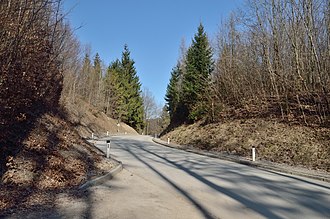
View from the southwest to the top of the pass |
|||
| Compass direction | west | Southeast | |
| Pass height | 698 m above sea level A. | ||
| district | Sankt Pölten-Land , Lower Austria | Lilienfeld , Lower Austria | |
| Watershed | Tradigistbach → Pielach → Danube | Schrambach → Traisen → Danube | |
| Valley locations | Tradigist | Schrambach | |
| expansion | Street (L5217) | ||
| Mountains | Türnitz Alps | ||
| profile | |||
| Ø pitch | 5.7% (313 m / 5.5 km) | 6.3% (304 m / 4.8 km) | |
| Map (Lower Austria) | |||
|
|
|||
| Coordinates | 48 ° 0 '47 " N , 15 ° 31' 56" E | ||
The Moarigrabensattel (also Margrabensattel ) is 698 m above sea level. A. high mountain pass in southern Lower Austria , which connects the Pielachtal with the Traisental . The pass is of local importance only.
The L5217 leads over the pass from Mariazeller Straße B 20 in Schrambach an der Traisen via Christenthal to the L107 near Tradigist (not far from Pielachtal Straße B 39 near Warth an der Pielach). The road is about ten kilometers long, climbs about 300 meters on both sides, and has an average gradient of about 6% on both sides, with three hairpin bends west of the saddle .
From the top of the pass to about 500 m east of it, the state road leads a short stretch with little incline through the municipality of Eschenau , before a cross and a chapel ( location ) are at a courtyard entrance . To the west below the top of the pass there is a French cross ( Lage ).
The saddle is located directly north of the Lindenberg ( 946 m above sea level ), to the east is the Lorenzipechkogel ( 883 m above sea level ). About three kilometers further north is the Geiseben ( 594 m above sea level ), another pass over which the L107 leads, then the Türnitz Alps slowly run out into the hilly country. To the south only the Türnitzer / Pielachtaler Gscheid ( 841 m above sea level ) offers a transition between the two valleys (apart from Puchenstuben - Annaberg between the valley ends over the Erlauf, already on the Ötscher).
The name is probably related to the Bavarian Moari 'border' as the pronunciation of Mark (-Stein) , referring to the old court border that ran here (today the district border between Sankt Pölten-Land and Lilienfeld ). However, the Swiss-German field name "Mörischlag" (later Märenschlag as the name of an alpine farm), which has been documented since the 15th century, as well as the place names Morgarten, Mörlialp, Marbach etc., point to a boggy land gained through clear cutting. Thus there is a relationship to Middle High German môr or mar (for moor ).
In 2012 the saddle was part of the mountain classification on the Tour of Austria .
Web links
Individual evidence
- ↑ Michael Hlatky: Morigraben - Schöngraben - Ebenwiesen - Hohenstein. In: Steinschalerwiki. August 31, 2014, accessed April 23, 2018 .
- ↑ Moarigrabensattel and the surrounding area on ÖK 50 , www.austrianmap.at , Federal Office for Metrology and Surveying Austria, Austrian map, scale 1: 50,000.
- ↑ a b NÖ Landesstraßenverzeichnis 8500 / 99-0, Stv. 84/00, 24 August 2000 (idgF ris.bka ).
- ^ Rupert Hauer: Local history of the Gmünd district . Verlag der Stadtgemeinde Kulturreferat, Gmünd 1951, p. 221; in the dialect Moristein is still alive for 'Grenzstein' or Morischlag for a cleared border in the high forest.
- ↑ Alfred Helfenstein: The Namengut Pilate territory. Keller, Luzern 1982, ISBN 3-85766-004-X , p. 48.
- ^ Ö-Tour: Österreicher conquers Bergtrikot , courier from July 6, 2012, online.


