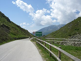
Sölkpass
| Sölkpass | |||
|---|---|---|---|
|
Pass summit on the Sölkpass |
|||
| Compass direction | North | south | |
| Pass height | 1788 m above sea level A. | ||
| district | Liezen , Styria | Murau , Styria | |
| Watershed | Großsölkbach → Sölkbach → Enns → Danube | Schöderbach → Katschbach → Mur → Drau → Danube | |
| Valley locations | Sankt Nikolai in Sölktal | Schöder | |
| expansion | Two-lane pass road | ||
| Built | 1954 | ||
| Mountains | Lower Tauern | ||
| profile | |||
| Ø pitch | 7.3% (661 m / 9.0 km) | 6.4% (887 m / 13.8 km) | |
| Max. Incline | 12% | 15% | |
| Map (Styria) | |||
|
|
|||
| Coordinates | 47 ° 16 '17 " N , 14 ° 4' 46" E | ||
The Sölkpass is a mountain pass over the Niedere Tauern in Styria ( Austria ).
topography
The pass lies on the sheath between the Wölzer and Schladminger Tauern and connects the Murtal with the Ennstal via a panoramic road , also known as the Erzherzog-Johann-Straße . Nearby places in the Murtal are Schöder , Murau and Oberwölz , and in the Ennstal Gröbming .
The height of the Sölkpass is 1788 m above sea level. A. The top of the pass offers little view, but there are a number of interesting views on the pass road itself. The state road L704, known as the Sölkpassstraße or Erzherzog-Johann-Straße , runs across it as a pass road . It was extensively expanded and paved with two lanes in 1954.
Adjacent crossings are the Radstädter Tauern Pass and the Tauern Tunnel in the west and the Trieben Tauern Pass in the east.
Winter closure
Because of its minor importance and the lack of avalanche protection structures, the pass road is not cleared in winter. There is no official winter closure, but the road is officially closed from the first snowfall, usually in October, until it is fully defrosted. Experience has shown that the Sölkpass is officially open from mid-May, the current status can be viewed on the Internet. A safe crossing would usually be possible earlier but is illegal due to the upright winter closure.
history
The Sölkpass was already used as a transport link in the late Bronze Age, as the foundations of a former hut in the area of the pass and remains of charcoal show.
In the late Middle Ages , the Sölkpass, which was sometimes referred to as the Sölkscharte, began to gain a certain regional importance. From this time onwards, an inspection is also documented. As early as 1593, a first project for the construction of a cart path over the Sölkpass was created, for which a cost estimate provided for an amount of 1460 guilders .
A little to the east of the Sölkpass is the 1987 m high Glattjoch , to which only a hiking trail leads today. In the 16th century, however, there was a locally significant mule track , and in 1574 they began to expand. This expansion, which dragged on for a whole hundred years, had to be discontinued without any results, and as a result the Glattjoch soon lost all local importance.
From the top bend on the north side you can still see an old mule track from the Middle Ages.
In 1978 a small chapel was built on the top of the pass.
August 2017 - suspension due to storm damage
At the beginning of August 2017, severe storms caused extreme damage on both sides. The Sölkpass was therefore closed for an uncertain time. At the beginning of July 2018, the Sölkpass was opened to traffic again.
tourism
Even today, the Sölkpass is hardly developed for tourism. There are hardly any noteworthy restaurants or hotels along the entire route. Nevertheless, the Sölktäler nature park offers many sights including culinary delights.
literature
- O. Fraydenegg-Monzello and A. Ziegenhofer, Der Sölkpaß, 1997.
- Sölkpass: A 6000 year old mule track across the Alps, ISBN 3-901071-14-8
- Steffan Bruns: Alpine passes - from the mule track to the base tunnel, vol. 4
Individual evidence
- ↑ http://www.alpenpaesse.co/OeSTERREICH-STEIERMARK-Soelkpass_p306
- ↑ http://www.greim.at/de/news.asp?n=4 Tourist information for the Greim holiday region
- ↑ http://www.greim.at/de/Soelkpass.asp?n=27
- ↑ https://www.kleinezeitung.at/steiermark/murtal/5266073/Nach-dem-Unwetter_Ungewisse-Zukunft-fuer-den-Soelkpass
- ↑ https://www.kleinezeitung.at/steiermark/ennstal/5461690/Freie-Fahrt_Endlich-Der-Soelkpass-ist-wieder-offen
- ↑ Sölkpassstraße can be used again after one year. In: steiermark.orf.at. July 10, 2018, accessed November 14, 2018 .
Web links
- Sölkpasstraße in the Ennstalwiki


