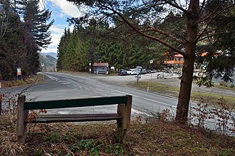
Gorge height
| Gorge height | |||
|---|---|---|---|
|
View towards Gölsental (southwest) |
|||
| Compass direction | Northeast | southwest | |
| Pass height | 618 m above sea level A. | ||
| state | Lower Austria | ||
| Watershed | Laabenbach → Great Tulln → Danube | Gölsen → Traisen → Danube | |
| Valley locations | Laaben | Hainfeld | |
| expansion | Road L119 | ||
| Mountains | Vienna Woods | ||
| Map (Lower Austria) | |||
|
|
|||
| Coordinates | 48 ° 3 '44 " N , 15 ° 50' 45" E | ||
The height of the gorge is 618 m above sea level. A. high mountain pass in southern Lower Austria . It overcomes the Vienna Woods between Gföhlberg ( 885 m above sea level ) and Schöpfl ( 893 m above sea level ). The gorge height forms a watershed between the Great Tulln and the Gölsen . The road L119 leading over the pass connects Laaben in the Sankt Pölten-Land district with the Gölsental in the Lilienfeld district . In addition, a road branches off from the L119 directly at Klammhöhe, which forms a connection to the Triestingtal and flows into Hainfelder Straße (B18) between Kaumberg and Thenneberg . South of the Klammhöhe is the Valeriehöhe ( 772 m ).
Web links
Commons : Klammhöhe - collection of images, videos and audio files
Individual evidence
- ↑ a b c Klammhöhe and surroundings on ÖK 50 , www.austrianmap.at , Federal Office for Metrology and Surveying Austria, Austrian map, scale 1: 50,000.

