
Klippitztörl
| Klippitztörl | |||
|---|---|---|---|
 Pass height |
|||
| Compass direction | west | east | |
| Pass height | 1644 m above sea level A. | ||
| state | Carinthia | ||
| Valley locations | Lölling Graben | Bad St. Leonhard | |
| expansion |
Klippitztörl Street |
||
| Mountains | Saualpe | ||
| profile | |||
| Ø pitch | 6.5% (934 m / 14.3 km) | 6.6% (978 m / 14.8 km) | |
| map | |||
|
|||
| Coordinates | 46 ° 56 '12 " N , 14 ° 40' 28" E | ||

The Klippitztörl describes a village, a pass road and a ski area on the Saualpe in Carinthia .
The village belongs to the municipality of Wolfsberg . The state road over the Klippitztörl connects the Wolfsberg district with the St. Veit district . The 28 km long pass road branches off south of Bad St. Leonhard from Obdacher Straße (B 78) towards west and leads over the apex at Klippitztörl at 1644 m above sea level and the village of Lölling- Graben to Görtschitztal-Straße (B 92) south of Hüttenberg .
Ski Area

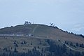
Hohenwart (right summit, 1818 m), from Lavanttal side

Town center

View of the village of Klippitztörl from the Geierkogel
Klippitztörl mountain station with lift and summer toboggan run


The ski area at the top of the pass includes three tow lifts, a two-seater and four-seater chairlift as well as ten blue and three red slopes on Hohenwart (1818 m). Alpine huts, holiday homes and hotels are offered for overnight stays along the pass road.
Summer tourism
In summer the Klippitztörl offers a wide network of hiking trails with many managed alpine huts and restaurants. A summer toboggan run and, from June 2011, a rope course are special attractions . The Eisenwurzenweg and the Panoramaweg Südalpen lead over the Klippitztörl .
Individual evidence
- ↑ Klippitztörl and the surrounding area on ÖK 50 , www.austrianmap.at , Federal Office for Metrology and Surveying Austria, Austrian map.
Web links
_COA.svg)
Cadastral communities: Aichberg | Floodplains | Forest | Graves-Prebl | Semolina | Hartelsberg | Hattendorf | Hintertheißenegg | Little thing | Kleinwinklern | Lading | Leiwald | Michaelsdorf | Oberleidenberg | Paildorf | Pfaffendorf | Preims | Creek | Reding | Reideben | Reisberg | Rieding | Ritzing | Schossbach | Alluvial rats | St. Jacob | St. Johann | St. Marein | St. Margarethen | St. Michael | St. Stefan | Thürn | Unterleidenberg | Vordergumitsch | Vordertheißenegg | Waldenstein | Weißenbach | Witra | Wolfsberg Upper City | Wolfsberg Lower City
Locations: Aichberg | Altendorf | Arling | Floodplains | Eselsdorf | Forest | Glein | Graves | Semolina | Grossedling | Hartelsberg | Hard cutting stone | Hattendorf | Hintertheißenegg | Kötsch | Little thing | Kleinwinklern | Klippitztörl | Kragelsdorf | Lading | Lausing | Leiwald | Magersdorf | Maildorf | Michaelsdorf | Oberleidenberg | Paildorf | Pfaffendorf | Pollheim | Prebl | Preims | Creek | Raggl | Reding | Reideben | Reinfelsdorf | Reisberg | Rieding | Riegelsdorf | Ritzing | St. Jacob | St. Johann | St. Marein | St. Margarethen im Lavanttal | St. Michael | St. Stefan | St. Thomas | Schilting | Grinding | Schossbach | Alluvial rats | Siegeldorf | Thürn | Unterleidenberg | Völking | Vordergumitsch | Vordertheißenegg | Wölling | Waldenstein | Weißenbach | Weißenbach Gumitsch | Weißenbach Rieding | Witra | Wois | Wolfsberg | Wolkersdorf
Districts:
Wolfsberg •
Gries •
United Edling •
Kleinedling •
Upper Town •
Priel •
Reding •
Ritzing •
St. Thomas •
grinding •
lap Bach •
Schwemmtratten •
St. Jakob •
St. Johann •
St. Stefan •
Lower Town
villages:
Altendorf •
Forest •
Hattendorf •
Maildorf •
Michaelsdorf •
Paildorf •
Pfaffendorf •
Prebl •
Riegelsdorf •
St. Margarethen im Lavanttal •
St. Michael •
Siegelsdorf •
St. Marein •
Theißenegg •
Völking •
Wolkersdorf |
Rotten:
Eselsdorf •
Kleinwinklern •
Kragelsdorf •
Lausing •
Magersdorf •
Pollheim •
Reideben •
Schilting •
Thürn •
Graves Twimberg |
Settlements:
Klippitztörl •
Pfaffendorf settlement •
Rieding-Koralpe •
Thonhausersiedung |
Scattered houses:
Aichberg •
Arling •
Auen •
Factory area •
Forest Schattseite •
Forest Sonnseite •
Glein •
Graves •
Hartelsberg •
Hartneidstein •
Hintertheissenegg •
Kötsch •
Lading •
Leiwald •
Oberleidenberg •
Preims •
Raggl •
Reinfelsdorf •
Reisberg •
Rieding •
Koralpe
Unterleidenberg •
Vordergumitsch •
Vordertheißenegg •
Waldenstein •
Weissenbach Gumitsch •
Weissenbach Rieding •
Witra •
Wois •
Wölling |
Other local documents:
Bad Weissenbach •
Castle Bayerhofen •
ruin Hartneidstein •
Klippitztörlhütte •
Castle Reid Eben •
Shoulder Kogel hut •
Castle Thürn •
Castle Under Wolfsberg •
Castle Waldstein •
Castle Weißenau •
Castle Wolfsberg •
Wolfsberger Hütte
Counting districts and districts: Old Town : Lower Town • Upper Town – Schoßbach | Inner city area : Gries • Reding-Nord • St. Jakob - Schleifen • Alluvial rats • Ritzing | Outer urban area : Reding-Süd • Priel-Süd • Priel-Nord • Auen | St.Stefan in Lavanttal : St.Stefan-Markt • Großedling - Wolkersdorf • St.Johann - Paildorf • St. Stefan-Berg | St.Marein : St.Marein • Kleinedling-W - St.Thomas • Kleinedling-Ost • Thürn • Aichberg • Reisberg | St.Michael : St.Michael • Lading • Witra - Forst-Süd | St.Margarethen in the L : St.Margarethen-Süd • Oberleidenberg - Preims • Forst - Leiwald | Gräbern-Prebl : Graves - Prebl -Süd • Wölling | Waldenstein : Waldenstein
Ahorn • Alpl • Ammer • Annaberg • Arlberg • Ascher • Bieler • Birkfelder • Boding • Brenner • Buchauer • Buchener • Dientner • Dürrholzer • Eibegg • Erb • Eisental • Faschina • Feistritz • Fern • Filzen • Flattnitz • Flexen • Forsthof • Furka • Fuscher • Gaberl • Gaden wide • Gailberg • Gangleit • Geiseben • Gerichtsberg • Gerlos • Geschriebenstein • Goller • Grießen • Griffner • Large Kripp • Grubberg • Grünbacher • Gschuett • Hafner • Hahntenn • neck • Haselrast • Hebalm • stallion • Hengstl • Hiaslegg • Hirschegger • Hochegger • Hochrindl • Hochtannberg • Hochtor • Holzleiten • Iselsberg • Josefsberg • Kaiserauer • Cold Kuchl • Kartitscher • Katsch • Kernhofer • Kerschbaumer • Klachauer • Klamm • Klamml • Small Kripp • Klippitz • Klostertaler • Kraxen • Kreuth • Kreuzberg • Kühtai • Lahn • Lienbach • Loibl • Losen • Luft • Mendling • Michelbühel • Moarigraben • Nassfeld • Neumarkter • Niederalpl • Norberts • Nöring • Obdacher • Oberjoch • Och • Pack • Paulitsch • Perchauer • Pfaffen • Pfarralm • Pielachtaler • Piller • Plöcken • Pogusch • Pölshals • Pötschen • Präbichl • Prebersattel • Preiner • Pretal • Promau • Pyhrn • Radl • Radling • Radstädter • Radstatt • Rams • Raneck • Rechberg • Rieder • Rohrer • Sattler • Saurüssel • Schaida • Schanz • Scharflinger • Schiestel • Schober • Schönfeld • Schwarze Sau • Schwarzenbichl • Seeberg • Seefelder • Semmering • Kleiner Semmering • Sieggraben • Silzer • Soboth • Summer • Staller • Styrian Seeberg • Straßegg • Sölk • Thurn • Timmels • Triebener Tauern • Turracher • Origin • Wechsel • Weinebene • Weißenbacher • Wagrainer • Windische • Wurzen • Zellerrain