
Pölshals
| Pölshals | |||
|---|---|---|---|
| Compass direction | North | south | |
| Pass height | 806 m above sea level A. | ||
| region | Pölstal | Murtal | |
| Valley locations | Pöls | Judenburg / Sankt Georgen ob Judenburg | |
| expansion | Triebener Strasse (B114 / B114a) | ||
| Mountains | Murberge : Habring / Falkenberg | ||
| map | |||
|
|||
| Coordinates | 47 ° 12 '54 " N , 14 ° 34' 27" E | ||

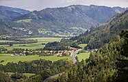
The Pölshals ( 806 m above sea level ) is a road pass in the Austrian state of Styria in the municipality of Pöls-Oberkurzheim , which connects the Pölstal with the Murtal .
Location and landscape
Like the other northern side valleys of the upper Mur in the Niedere Tauern, the Pölstal strikes in its lower section strongly southeast to eastwards before it enters the Judenburg basin of the Mur. It runs for several kilometers almost parallel to the Murtal, separated from the long ridge of the Falkenberg ( 1158 m above sea level ). About 8 kilometers upstream from Judenburg, where the Pöls briefly only approaches the Mur for about 1½ km, there is a clear saddle, the Pölshals. It is only 100 meters above the Murtal, and right at the bottom of the valley in the Pölstal near Pöls . To the west of the pass stands the Raningerkogel ( 945 m above sea level ), as the foothills of the Habring massif ( 1497 m above sea level ) of the Murberge .

The Pölshals, from the Murtal, into the valley, with Bocksruck back
The Pölshals, out of the murtal, with Falkenberg

The Pölshals, from the Pölstal


geology
The Pölshals Saddle is based on a north-south trending local geological fault (Pölshals fault ) . It was overflowed by the Murtal Glacier during the maximum freezing of the Mur to the north, where it formed a lobus-shaped lateral glacier tongue in the Pölstal (the Murtal main stream, itself just a tributary of the entire glacier that flowed to Carinthia, ended at Judenburg am Grünhübl ).
History and expansion
The Pölshals represents an ancient connection, archaeological traces go back to the Neolithic. A Roman road has already led into the Pölstal on a route that is very similar to today's. It probably belonged to the Noric road Virunum - Ovilava (Carinthia - Upper Austria) Neumarkter Sattel - Triebener Tauern - Pyhrn . At the top of the pass, where road and settlement remains were found, the Roman post office could have been located for months . The church of Ad Undrimas , mentioned for 767 during the time of the Slavic mission, was also assumed to be here. The current name is younger, neck is an old word for passports.
Two road connections use this pass today:
- The new Pölshals Triebener Straße B 114, which connects Pöls southeast with Thalheim and subsequently with Judenburg .
- The old Pölshals Triebener Straße B 114a, which connects Pöls with Sankt Georgen ob Judenburg . It branches off directly at the top of the pass from the new Pölshals in a south-west direction, and then leads up the Mur to Sankt Georgen .
The B 114a (old Pölshals) is known as an insider tip and courageous route among motorcyclists due to its ancient route - unusual steep crests and depressions, as well as curves without clothoids .

Road alignment according to standards that are no longer common today, with crests and tight curves.

One of the many tight bends on the B 114a, the old Triebener Straße.
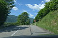
Ancient route with tight curves.


Web links
Individual evidence
- ↑ a b Geological map of the Republic of Austria 1:50 000, explanations on sheet 160 Neumarkt in Steiermark. Federal Geological Institute, Vienna 1980; P. 27 (Andreas Thurner) resp. P. 50 (Dirk van Husen: Quaternary ; also map in the appendix) ( pdf , geologie.ac.at; map pdf p. 67).
- ↑ Conversio Bagoariorum et Carantorum.
- ↑ Manfred Straka ( arr .): “Ad Undrimas” and no end. In: Blätter für Heimatkunde 49 (1975), pp. 61–68 ( article pdf , historerverein-stmk.at ) - essay by Karl Bracher on Walter Brunner: Die Kirche “ad Undrimas”. In: Mitteilungen des Institut für Österreichische Geschichtsforschung 82/1974, pp. 1-29; with reply.
Ahorn • Alpl • Ammer • Annaberg • Arlberg • Ascher • Bieler • Birkfelder • Boding • Brenner • Buchauer • Buchener • Dientner • Dürrholzer • Eibegg • Erb • Eisental • Faschina • Feistritz • Fern • Filzen • Flattnitz • Flexen • Forsthof • Furka • Fuscher • Gaberl • Gaden wide • Gailberg • Gangleit • Geiseben • Gerichtsberg • Gerlos • Geschriebenstein • Goller • Grießen • Griffner • Large Kripp • Grubberg • Grünbacher • Gschuett • Hafner • Hahntenn • neck • Haselrast • Hebalm • stallion • Hengstl • Hiaslegg • Hirschegger • Hochegger • Hochrindl • Hochtannberg • Hochtor • Holzleiten • Iselsberg • Josefsberg • Kaiserauer • Cold Kuchl • Kartitscher • Katsch • Kernhofer • Kerschbaumer • Klachauer • Klamm • Klamml • Small Kripp • Klippitz • Klostertaler • Kraxen • Kreuth • Kreuzberg • Kühtai • Lahn • Lienbach • Loibl • Losen • Luft • Mendling • Michelbühel • Moarigraben • Nassfeld • Neumarkter • Niederalpl • Norberts • Nöring • Obdacher • Oberjoch • Och • Pack • Paulitsch • Perchauer • Pfaffen • Pfarralm • Pielachtaler • Piller • Plöcken • Pogusch • Pölshals • Pötschen • Präbichl • Prebersattel • Preiner • Pretal • Promau • Pyhrn • Radl • Radling • Radstädter • Radstatt • Rams • Raneck • Rechberg • Rieder • Rohrer • Sattler • Saurüssel • Schaida • Schanz • Scharflinger • Schiestel • Schober • Schönfeld • Schwarze Sau • Schwarzenbichl • Seeberg • Seefelder • Semmering • Kleiner Semmering • Sieggraben • Silzer • Soboth • Summer • Staller • Styrian Seeberg • Straßegg • Sölk • Thurn • Timmels • Triebener Tauern • Turracher • Origin • Wechsel • Weinebene • Weißenbacher • Wagrainer • Windische • Wurzen • Zellerrain