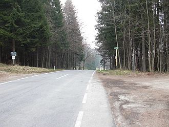
Ashtray (passport)
| Ashtray (passport) | |||
|---|---|---|---|
|
Pass with bus stop |
|||
| Compass direction | southwest | Northeast | |
| Pass height | 740 m above sea level A. | ||
| state | Lower Austria | ||
| Watershed | Pfennigbach → Sierning → Schwarza → Leitha → Danube | Kaltenbergbach → Miesenbach → Waidmannsbach → Piesting → Fischa → Danube | |
| Valley locations | Puchberg am Schneeberg | Miesenbach | |
| expansion | L138 | ||
| Mountains | Gutenstein Alps | ||
| profile | |||
| Ø pitch | 3.9% (155 m / 4.0 km) | 3.6% (270 m / 7.6 km) | |
| Map (Lower Austria) | |||
|
|
|||
| Coordinates | 47 ° 48 '50 " N , 15 ° 56' 29" E | ||
The ashtray is 740 m above sea level. A. high pass in the Lower Austrian Alps. It forms a cut between the Haltberg ( 1114 m above sea level ) in the west and the Hutberg ( 971 m above sea level ) in the east. The road L138 (Ascherstraße) running over the Ascher leads from Puchberg am Schneeberg in the Neunkirchen district to Miesenbach in the Wiener Neustadt-Land district . The top of the Ascher pass is in the municipality of Puchberg am Schneeberg. It forms a watershed between the Piesting and Schwarza rivers.
Individual evidence
- ↑ a b c ÖK50 in: www.austrianmap.at , Federal Office for Metrology and Surveying Austria, Austrian map, scale 1: 50,000.

