Furkajoch
| Furkajoch | |||
|---|---|---|---|
|
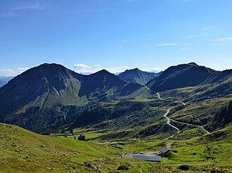
View of the Furkajoch from the east |
|||
| Compass direction | west | east | |
| Pass height | 1759 m above sea level A. | ||
| state | Vorarlberg , Austria | ||
| Watershed | Frutz , Rhine | Ladritschbach , Lutz , Ill , Rhine | |
| Valley locations | Lanterns | Damuls | |
| expansion | Street | ||
| Winter closure | Yes | ||
| profile | |||
| Ø pitch | 5.93% (1293 m / 21.8 km) | 4.33% (329 m / 7.6 km) | |
| Map (Vorarlberg) | |||
|
|
|||
| Coordinates | 47 ° 16 '0 " N , 9 ° 49' 58" E | ||
The Furkajoch is a mountain pass (pass height 1759 m above sea level , up to 14% gradient) in the Alps ( Eastern Alps , Northern Limestone Alps ). It is located in Austria (state of Vorarlberg ) and connects the valley of the Bregenzer Ach ( Bregenzerwald ) near Damüls with the valley of the Frutz ( Laternsertal ) near Laterns .
The Furkajoch ( Italian forca , mountain pass, name with Rhaeto-Romanic roots) is a pass crossing with old but purely local significance. The pass path was made correspondingly simple and, until recently, was little more than a natural path. Only a few years ago a modern, narrow street was built over the Furkajoch, the state road L 51 Laternser Straße Rankweil - Laterns - Damüls . The route is popular with motorcyclists and is closed in winter.
Web links
Individual evidence
- ^ ÖK 50 , www.austrianmap.at , Federal Office for Metrology and Surveying Austria, Austrian map.
- ^ Steffan Bruns: Alpine passes . The passes between Lake Constance and Lake Como. tape 2 . L. Staackmann Verlag, Munich 2010, ISBN 978-3-88675-281-2 , p. 29 .


