
Buchener height
| Buchener height | |||
|---|---|---|---|
 Pass summit, in the background the Hohe Munde |
|||
| Compass direction | North | south | |
| Pass height | 1247 m above sea level A. | ||
| state | Tyrol | ||
| Watershed | Ostbach, Leutascher Ache , Isar | Inn | |
| Valley locations | Leutasch | Telfs | |
| expansion | Pass road | ||
| Mountains | Mieminger Mountains | ||
| profile | |||
| Ø pitch | 1.6% (111 m / 7 km) | 6.1% (614 m / 10 km) | |
| map | |||
|
|||
| Coordinates | 47 ° 20 '16 " N , 11 ° 7' 23" E | ||

The road over the Buchener Höhe connects the towns of Leutasch and Telfs in Tyrol / Austria . The route contains 4 hairpin bends and the pass is at 1247 m above sea level. A. In a north-easterly direction, the road from Leutasch continues to Mittenwald in Bavaria / Germany . To the west of the Buchener Höhe is the 2,662 m high Hohe Munde .
photos
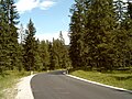
Buchener Höhe, north ramp near the top of the pass
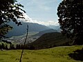
Buchener Höhe, south ramp, view of Telfs and the Inn Valley


Individual evidence
- ↑ ÖK50 in: www.austrianmap.at , Federal Office for Metrology and Surveying Austria, Austrian map, scale 1: 50,000.
- ↑ Passport data , in: www.passknacker.com , accessed on February 5, 2016>
- ↑ Tour description with access via Buchener Höhe in: www.berghaben.com , accessed on February 5, 2016
Ahorn • Alpl • Ammer • Annaberg • Arlberg • Ascher • Bieler • Birkfelder • Boding • Brenner • Buchauer • Buchener • Dientner • Dürrholzer • Eibegg • Erb • Eisental • Faschina • Feistritz • Fern • Filzen • Flattnitz • Flexen • Forsthof • Furka • Fuscher • Gaberl • Gaden wide • Gailberg • Gangleit • Geiseben • Gerichtsberg • Gerlos • Geschriebenstein • Goller • Grießen • Griffner • Large Kripp • Grubberg • Grünbacher • Gschuett • Hafner • Hahntenn • neck • Haselrast • Hebalm • stallion • Hengstl • Hiaslegg • Hirschegger • Hochegger • Hochrindl • Hochtannberg • Hochtor • Holzleiten • Iselsberg • Josefsberg • Kaiserauer • Cold Kuchl • Kartitscher • Katsch • Kernhofer • Kerschbaumer • Klachauer • Klamm • Klamml • Small Kripp • Klippitz • Klostertaler • Kraxen • Kreuth • Kreuzberg • Kühtai • Lahn • Lienbach • Loibl • Losen • Luft • Mendling • Michelbühel • Moarigraben • Nassfeld • Neumarkter • Niederalpl • Norberts • Nöring • Obdacher • Oberjoch • Och • Pack • Paulitsch • Perchauer • Pfaffen • Pfarralm • Pielachtaler • Piller • Plöcken • Pogusch • Pölshals • Pötschen • Präbichl • Prebersattel • Preiner • Pretal • Promau • Pyhrn • Radl • Radling • Radstädter • Radstatt • Rams • Raneck • Rechberg • Rieder • Rohrer • Sattler • Saurüssel • Schaida • Schanz • Scharflinger • Schiestel • Schober • Schönfeld • Schwarze Sau • Schwarzenbichl • Seeberg • Seefelder • Semmering • Kleiner Semmering • Sieggraben • Silzer • Soboth • Summer • Staller • Styrian Seeberg • Straßegg • Sölk • Thurn • Timmels • Triebener Tauern • Turracher • Origin • Wechsel • Weinebene • Weißenbacher • Wagrainer • Windische • Wurzen • Zellerrain