
Nockalmstrasse
| Eisentalhöhe | |||
|---|---|---|---|
 Panoramic view over the mountains on the Nockalmstrasse |
|||
| Compass direction | North | south | |
| Pass height | 2049 m above sea level A. | ||
| state | Carinthia , Austria | ||
| Valley locations | Innerkrems | Schiestelscharte / level Reichenau | |
| expansion | Pass road (toll) | ||
| Lock | October - May cars with caravans |
||
| Mountains | Gurktal Alps | ||
| particularities | Subject to toll | ||
| profile | |||
| Denzel scale | SG 2 | ||
| Ø pitch | 8% (2632 m / 33 km) | ||
| Map (Carinthia) | |||
|
|||
| Coordinates | 46 ° 56 '8 " N , 13 ° 45' 33" E | ||

The Nockalmstraße is a toll road in Carinthia , Austria . It leads from Innerkrems over the Eisentalhöhe ( 2049 m above sea level ), Karlbad , Grundtal, Schiestelscharte and Winkltal to Ebene Reichenau . The operator has been Großglockner Hochalpenstraßen AG since 1995 .
history
In a study presented by the Carinthian state government in 1971, the construction of the Nockalmstrasse was decided. On the one hand, it should connect the Tauern Autobahn , which is currently under construction, to the Liesertal , and on the other, improve the connection between the Nockberge and the central region of the state. It was hoped that this would promote tourism in the Nock area, and the road should also bring advantages for forestry and alpine farming, which could better use vehicles for transportation to and from the area.
There were also plans to build a new ski area for the area on both sides of the street, but these were rejected due to the protests of a citizens' initiative and the subsequent referendum. Instead, it was decided to declare the open landscape on both sides of the Nockalm Road as the core zone of the 216 km² Nockberge National Park on January 1, 1987 .
The Nockalmstraße, meanwhile asphalted, was opened to traffic as a toll road in 1981 after several years of construction - the construction costs amounted to almost 100 million schillings (7.27 million euros), after it was passed in a very gentle manner due to its gentle crests so called Nockberge was built.
course
Over a length of 35 kilometers, the Nockalmstraße meanders over 52 hairpin bends between Innerkrems and Reichenau with a maximum gradient of 12% through the low mountain range. Before Ebene Reichenau opens the road to the national highway 95 , the former steepest mountain road in Europe, the Carinthia on the Turracherhöhe with the Styria connects.
Since 2006, every turn (labeled “Reidn” in Carinthian dialect) has been named for a local plant. With this, the operator of the street wants to make a contribution to the preservation of the local dialect.
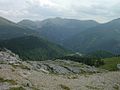
The route, which is also suitable for inexperienced cyclists, motorcyclists and drivers, offers unique views. Several huts managed as inns , nature trails, an alpine farm museum, a healing spring and the two highest points of the route on the Eisentalhöhe ( 2049 m above sea level , ⊙ ) and on the Schiestelscharte ( 2027 m above sea level , ⊙ ) are popular stops the Nockalmstrasse.
The street is open from May to October (weather-related changes are possible) from 8 a.m. to 6 p.m. and is managed by Großglockner Hochalpenstraßen AG . The Nockalmstraße is closed to cars with caravans . Motorcycles are not allowed on the road between 6:00 p.m. and 8:00 a.m.
Blumenreidn
In the Carinthian dialect, sharp road bends are called "Reidn". The Reidn along the Nockalmstraße have had the dialect names of local flowers in the Carinthian dialect since 2006. Deserved Carinthian personalities have been immortalized in the individual Reidn, such as B. the Olympic champion Thomas Morgenstern . A hiking trail was named after the inventor of the Blumenreidn and the former landlady of the Glockenhütte on the Schiestelscharte, Elisabeth Pusca. The "Elisabethweg" leads hikers over a steep 100 meters from Windebensee to the top of the pass "Schiestelscharte".
Illustrations
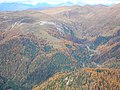
View over the Nockberge with the Nockalmstrasse
The road can be seen in the middle in the valley and on the right edge of the picture
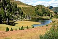
Windebensee east of the Schiestelscharte

The highest point on the Nockalm Road


See also
Web links
Individual evidence
- ↑ Harald Denzel: Great Alpine Road Guide. 22nd edition. Denzel-Verlag, Innsbruck 2005, ISBN 3-85047-764-9 .
- ↑ Blumenreidn Festival: July 23: 52 turns (Reidn) are given names from the plant world. Press release APA-OTS, July 19, 2006, last accessed January 31, 2016.
- ↑ a b Austrian Map online 1: 50,000 (ÖK 50) of the BEV
- ↑ https://www.nockalmstrasse.at/na/de/preiseundoeffnungszeiten
Ahorn • Alpl • Ammer • Annaberg • Arlberg • Ascher • Bieler • Birkfelder • Boding • Brenner • Buchauer • Buchener • Dientner • Dürrholzer • Eibegg • Erb • Eisental • Faschina • Feistritz • Fern • Filzen • Flattnitz • Flexen • Forsthof • Furka • Fuscher • Gaberl • Gaden wide • Gailberg • Gangleit • Geiseben • Gerichtsberg • Gerlos • Geschriebenstein • Goller • Grießen • Griffner • Large Kripp • Grubberg • Grünbacher • Gschuett • Hafner • Hahntenn • neck • Haselrast • Hebalm • stallion • Hengstl • Hiaslegg • Hirschegger • Hochegger • Hochrindl • Hochtannberg • Hochtor • Holzleiten • Iselsberg • Josefsberg • Kaiserauer • Cold Kuchl • Kartitscher • Katsch • Kernhofer • Kerschbaumer • Klachauer • Klamm • Klamml • Small Kripp • Klippitz • Klostertaler • Kraxen • Kreuth • Kreuzberg • Kühtai • Lahn • Lienbach • Loibl • Losen • Luft • Mendling • Michelbühel • Moarigraben • Nassfeld • Neumarkter • Niederalpl • Norberts • Nöring • Obdacher • Oberjoch • Och • Pack • Paulitsch • Perchauer • Pfaffen • Pfarralm • Pielachtaler • Piller • Plöcken • Pogusch • Pölshals • Pötschen • Präbichl • Prebersattel • Preiner • Pretal • Promau • Pyhrn • Radl • Radling • Radstädter • Radstatt • Rams • Raneck • Rechberg • Rieder • Rohrer • Sattler • Saurüssel • Schaida • Schanz • Scharflinger • Schiestel • Schober • Schönfeld • Schwarze Sau • Schwarzenbichl • Seeberg • Seefelder • Semmering • Kleiner Semmering • Sieggraben • Silzer • Soboth • Summer • Staller • Styrian Seeberg • Straßegg • Sölk • Thurn • Timmels • Triebener Tauern • Turracher • Origin • Wechsel • Weinebene • Weißenbacher • Wagrainer • Windische • Wurzen • Zellerrain