
Gurktal Alps
| Gurktal Alps | ||
|---|---|---|
| Highest peak | Eisenhut ( 2441 m above sea level ) | |
| location | Carinthia , Salzburg and Styria , Austria | |
| part of | Central Alps | |
| Classification according to | AVE 46a | |
|
||
| Coordinates | 46 ° 57 ' N , 13 ° 56' E | |


The Gurktal Alps are a mountain group in the central Eastern Alps in Austria between the Mur in the north and the Gurk in the south. They extend in the west to about Lake Millstatt and in the east to the Neumarkter Sattel (north-northwest of Neumarkt in der Steiermark ). The highest peak is the Styrian Eisenhut ( 2441 m ).
In terms of landscape, the Klagenfurt Basin , which adjoins to the south and extends to the Drau , with other smaller mountain ranges and with most of the Carinthian lakes is added to the Gurktal Alps.
structure
The Gurktal Alps can be divided into five groups:
- The Nockberge lie between Liesertal and Flattnitzer Höhe . The highest peak is the Eisenhut ( 2441 m ).
- The Metnitz Mountains lie between the Mur and Metnitz valleys. The highest peak is the Goldachnock ( 2171 m ).
- The Mödringbergzug lies between the Metnitz and Gurktal valleys. The highest elevation are the village corners ( 1726 m )
- The Wimitz Mountains lie between the Gurk and Glantal valleys and are traversed by the Wimitz . The highest peaks are the Schneebauerberg and the Hocheck ( 1338 m each )
The Klagenfurt Basin forms the southern end of the Gurktal Alps . There are seven other smaller mountain ranges:
- Magdalensberg (Lippekogel, 1079 m )
- Ossiacher Tauern (Taubenbühel 1069 m )
- Glantaler Bergland ( Ulrichsberg , 1022 m )
- Sattnitz (dance floor, 929 m )
- Feldkirchen-Moosburger Hügelland (Freudenberg, 817 m )
- St. Veiter Hügelland (Buchberg, 808 m )
- Maria Saaler Hügelland (Maria Saaler Berg, 746 m )
Occasionally, the Gurktal Alps, which are not geologically founded, are combined with the Lavanttal Alps to the east to form the Noric Alps .
geology
The Gurktal Alps essentially consist of three tectonic nappes : at the bottom the “ mica slate ceiling”, above the “Murau ceiling” and above the “ Stolzalpen ceiling ”. When Europe (in broad terms), Africa (in broad terms) and the oceanic area in between were "pushed together", the affected, e. Sometimes several hundred million year old rock units are pushed and stacked on top of each other. The deepest of these ceilings consists primarily of garnet mica schist , the middle one of " green schist " (converted volcanic rock), " phyllite " (converted clayey deposits) and marbles (converted limestone), all of which were originally about 500 to 400 million years old. The highest, the uppermost ceiling, the Stolzalpen ceiling, originally consists of rocks of about the same age, but which are less transformed and which are present today as clay slate , "meta- volcanic rocks " and limestone .
The rocks of the "mica slate ceiling" (also "diaphthoritic mica slate") occur z. B. in the immediate vicinity of Strasbourg and extend from there to the vicinity of St. Jakob ob Gurk . The rocks of the highest ceiling, the Stolzalpen ceiling occur z. B. at Weitensfeld . Areas of the Mödringberg range belong to the "Murau ceiling". It is primarily green slate and phyllite, the latter rather dark, even black, so-called graphite phyllite. A large part of the areas are “very young” (less than 1 million years old).
Economy and tourism

Due to the gentle landscape, there was a lot of alpine farming in the past . The mining ( iron ; vgl.:Eisenhut and silver ) was for centuries, but was only in Radenthein productive ( magnesite the firm. RHI AG ).
Today tourism is the most important industry. The valleys of the Gurktal Alps are well developed thanks to summer and especially lively winter tourism. The most prominent tourist community is Bad Kleinkirchheim , next to Turracher Höhe (communities Predlitz-Turrach and Reichenau ), Falkert (community Reichenau) and Innerkrems (community Krems in Carinthia ), Flattnitz , Afritz and Katschberg (community Rennweg am Katschberg ). The largest ski areas in the Nockberge are Katschberg-Aineck , Innerkrems-Schönfeld-Karneralm , Turracher Höhe and Gerlitzen as well as Kreischberg in the Metnitz mountains.
The Nockberge region is also known for its medicinal springs. The Karlbad along the Nockalmstraße is considered the oldest farm spa in Austria. The way the baths are made (spring water and hot stones) has not changed since the 17th century. Due to the remote location, there is also no electricity. The name of the bath can be traced back to the small Kar (= Karl).
natural reserve

Since the 1980s, the Nockalm Road (up to 2049 m above sea level ) has been winding its way from the Gurktal into the Innerkrems. This area was later declared the Nockberge National Park . In the northeast, between Murau and the Neumarkter Sattel , is the Grebenzen Nature Park .

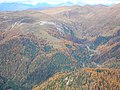
Nockberge, a late summer morning looking towards the Carnic Alps
Nockberge in the Nockalmstrasse / Karlbad area


Web links
Individual evidence
- ↑ Entry on Noric Alps in the Austria Forum (in the AEIOU Austria Lexicon )
- ↑ Georg Kleinschmidt , Andreas Mann, Thomas Angerer, Carsten Laukamp, Anna Leonhard: Report 1997 and 1998 on geological recordings on sheet 185 Strasbourg - Yearbook of the Federal Geological Institute - 142 . 2000, p. 405–408 ( PDF on ZOBODAT - summary by Prof. Kleinschmidt from June 28, 2020 ).
Ankogel Group | Glockner Group | Goldberg Group | Garnet group | Gurktal Alps | Kitzbühel Alps | Kreuzeckgruppe | Lavantal Alps | Oetztal Alps | Radstädter Tauern | Prealps East of the Mur | Rätikon | Rieserferner Group | Rottenmanner and Wölzer Tauern | Samnaun group | Sarntal Alps | Schladminger Tauern | Schobergruppe | Seckauer Tauern | Sesvenna group | Silvretta | Stubai Alps | Tux Alps | Venediger Group | Verwall | Villgraten Mountains | Zillertal Alps