Schladminger Tauern
| Schladminger Tauern | ||
|---|---|---|
| Highest peak | Hochgolling ( 2862 m above sea level ) | |
| location | Styria , Salzburg | |
| part of | Lower Tauern , Central Eastern Alps | |
| Classification according to |
AVE 45b SOIUSA 18.II Lgld.d.Stmk. NT.1 Trimmel 2620 |
|
|
|
||
| Coordinates | 47 ° 16 ' N , 13 ° 46' E | |
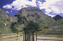
The Schladminger Tauern are a mountain group of the central Eastern Alps . Together with the Radstädter Tauern , the Rottenmanner and Wölzer Tauern and the Seckauer Tauern , the Schladminger Tauern form the large group of the Niedere Tauern . The mountains are located in Austria in the federal states of Salzburg and Styria . The highest point is the Hochgolling with 2862 m .
location
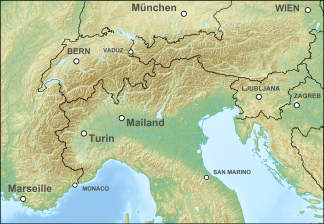
The Schladminger Tauern are located in the middle part of the Niedere Tauern. It is named after the city of Schladming in the Ennstal .
Boundary and neighboring mountain groups
The usual delimitation of the Schladminger Tauern is roughly the same between the Sölktal in the east and Obertauern (Tauern Pass) in the west, the Altenmarkt basin and Ennstal in the north. Only the southern border is strictly orographically different with the Upper Murtal or geological-landscape with the Murparalleltal, which runs just north, depending on the structure.
According to the Alpine Club division of the Eastern Alps (AVE), where they have the number 45b, they border on:
- in the northwest: Enns down from Radstadt (mouth of the Taurach) to the confluence of Mandling with the Salzburg Slate Alps (12)
- in the north: Enns down via Schladming to Gröbming / Stein (confluence with Großsölkbach, approx. 668 m ) to the Dachstein Mountains (14)
- in the east: Großsölkbach - Sölkpass ( 1788 m ) - Katschbach to Katsch an der Mur / Frojach (mouth approx. 752 m ) to the Rottenmanner and Wölzer Tauern (45c)
- in the south of the Mur upwards via Murau and Tamsweg to Unterbayrdorf to the Gurktal Alps (46a)
- in the west: Neuseß valley pass - Großenbach near Mauterndorf - southern Taurach upwards - Radstädter Tauernpass 1738 m - northern Taurach to the confluence with Radstadt and the Radstädter Tauern (45a)
- This boundary at Neuseß includes the Mitterberg (Höhenbühel) , a small island mountain on the Tamsweg basin .
Bordering the Murparalleltal (also in sections):
- In the landscape structure of Styria (NT.1) in the north of the Dachstein group (N.1); in the east Wölzer Tauern (NT.2); in the south Oberzeiring - Salchau - Oberwölz - St. Peter am Kammersberg - Krakau : Murberge (Z.1)
- Because this structure is only defined for Styria, neither the Radstädter Tauern nor the Slate Alps are included; Gstoder , Überling-Höhenzug (Weidschober) and Stolzalpe fall into the Murberg Mountains, which are calculated entirely independently; the Middle Ennstal (T.1) is treated separately as a valley area, so that the northern border runs at the foot of the mountain, not in the Enns.
- In the mountain group structure according to Trimmel (main group 2620) in the north of Enns to Mandling: Fritztaler Berge (1430); to the mouth of the Sölkbach: Dachstein (1540); in the east Wölzer Tauern (2630); in the south Mur to Thayabach mouth (Teufenbach): Seetal Alps (2760); to Katschbach estuary (Frojach): Gurktaler Alps (2730); Katschbach - Schöderbach - Krakaudorf - Etrachbach - Rantenbach - Seetaler Bach - Leißnitzbach : Murauer Mountains (2740); in the west both Taurachs from Tamsweg: Radstädter Tauern (2610)
- This means that Gstoder and Stolzalpe do not fall into the Schladminger Tauern, but the Mitterberg and Überling do.
The international unified orographic division of the Alps (IVOEA / SOIUSA) follows the concept of the AVE for the term Schladminger Tauern iwS (18.II) of the Lower Tauern, and gives the Schladminger Tauern in the narrower sense (A) and the Murau Alps (B) with Mitterberg, Weidschober / Überling-Zug, Gstoder, Stolzalpen region
Historically, there was a concept of structuring the Niedere Tauern with the Sölker Alps as a central section, with a south-eastern border along the Kleinsölkbach - Tamsweg line and thus the significantly smaller extent of the Schladminger Tauern.
Structure and division


The Schladminger Tauern is subdivided by the north-south-trending Tauern valleys of the Ennstal and the south-north-trending north valleys of the Lungau and the Upper Mur Valley , which are ten larger brooks on the north and south roofs (such as Forstau- , Preunegg- , valley , Weißpriach- , Göriach- , Lessach- , Etrach- , Schöder- , Katschberg , Hinteregg- , Schöttlbach ). These separate numerous narrow ridges from the group, which accompany the west-east running main ridge like a herringbone. Only in the northeast are Untertalbach to Kleinsölkbach more fan-shaped, so that the Sölktäler take up a more independent space.
To the south, the Mur is accompanied by the Murparalleltal to the north ( Krakau - St. Peter am Kammersberg - Oberwölz and further), here the valley direction changes to northwest-southeast and the mountains show the characteristics of a low mountain range of single levels, which is called Murberge , and partly independent, because of its geological conditions it is sometimes not even counted as part of the Schladminger (and Wölzer Tauern), but as part of the Gurktalern.
A common breakdown into six subgroups according to the most important peaks in the main ridge and valleys is (from west to east):
-
Seekarspitzen group between Radstädter Tauern ( 1738 m above sea level ) and Oberhüttensattel ( 1866 m above sea level ):
- Great Gurpitscheck ( 2526 m above sea level )
- Gamskarlspitze ( 2411 m above sea level )
- Seekarspitze ( 2350 m above sea level )
-
Kalkspitzen group between Oberhüttensattel ( 1866 m above sea level ) and Lignitzhöhe ( 2205 m above sea level ):
- Hundstein ( 2614 m above sea level )
- Vettenspitzen ( 2524 m above sea level )
- Styrian ( 2459 m above sea level ) and Lungauer Kalkspitze ( 2471 m above sea level )
- Zinc wall ( 2442 m above sea level )
- Schiedeck ( 2339 m above sea level ) and Hochwurzen ( 1850 m above sea level )
- Schober ( 2133 m above sea level ), Gasselhöhe ( 2001 m above sea level ) and Reiteralm
-
Hochgolling group between Lignitzhöhe ( 2205 m above sea level ) and Waldhorntörl ( 2283 m above sea level ):
- Hochgolling ( 2862 m above sea level )
- Kasereck ( 2740 m above sea level )
- Elendberg ( 2672 m above sea level )
- Zwerfenberg ( 2642 m above sea level )
- Hocheck ( 2638 m above sea level )
- Greifenberg ( 2618 m above sea level )
- Steinkarzinken ( 2281 m above sea level )
-
Hochwildstellen group between Waldhorntörl ( 2283 m above sea level ) and Lanschitzscharte ( 2345 m above sea level ):
- Hochwildstelle ( 2747 m above sea level )
- Waldhorn ( 2702 m above sea level )
- Deichselspitze ( 2684 m above sea level )
- Hohes Schareck ( 2575 m above sea level )
- Höchstein ( 2543 m above sea level )
- Pleschnitzzinken ( 2112 m above sea level )
- Hauser Kaibling ( 2015 m above sea level )
-
Preber group between Lanschitzscharte ( 2345 m above sea level ) and Hubenbauertörl ( 2051 m above sea level ):
- Roteck ( 2742 m above sea level )
- Preber ( 2740 m above sea level )
- Predigtstuhl ( 2543 m above sea level )
-
Knallstein group between Hubenbauertörl ( 2051 m above sea level ) and Sölkpass ( 1788 m above sea level ):
- Großer Knallstein ( 2599 m above sea level )
- Rupprechtseck ( 2591 m above sea level )
See also
literature
- Peter Holl: Alpine Club Guide Niedere Tauern. Bergverlag Rudolf Rother, Munich 1983, ISBN 3-7633-1231-5 .
Web links
Individual evidence
- ^ So in the much-used division of the Eastern Alps according to August von Böhm 1887.


