Ankogel Group
| Ankogel Group | |
|---|---|
|
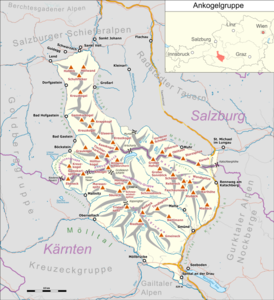
Overview map of the Ankogel group |
|
|
Hochalmspitze from the west |
|
| Highest peak | Hochalmspitze ( 3360 m above sea level ) |
| location | Carinthia and Salzburg , Austria |
| part of | Central Eastern Alps |
| Classification according to | AVE 44, Trimmel 2590, Ankogel – Hochalmgruppe SOIUSA II / A-17.II-F |
| Coordinates | 47 ° 1 ' N , 13 ° 19' E |
| rock | Tauern window |
| surface | 1,191.3 km² |
The Ankogel Group is a mountain group in the central Eastern Alps . The Ankogel Group is located in Austria on the border between the federal states of Salzburg and Carinthia . The highest peak is the Hochalmspitze , 3360 m above sea level. A. , namesake is the Ankogel mountain , 3252 m above sea level. A. Hence the name of the Ankogel – Hochalmspitz Group .
Concept history
Concept and name of Ankogelgroup was in 1845 by Adolf Schaubachhütte in his standard work The German Alpine as a group of Ankogls introduced the Ankogelgroup however, was still narrower. The Arlscharte ( 2252 m ) served as the eastern border and the Korntauern ( 2459 m ) as the western border . Schaubach chose the name after the Ankogel , which in his opinion is the highest mountain in the group. In its current boundaries up to Murtörl ( 2260 m ), the Ankogel group was first found in 1887 in the important division of the Eastern Alps by August Böhm von Böhmersheim . It can also be found in the Alpine Club classification of the Eastern Alps (AVE) according to Moriggl (1924) and Grassl (1978).
Boundary and neighboring mountain groups
Together with the Goldberg Group , the Glockner Group , the Schober Group , the Kreuzeck Group , the Granatspitz Group , the Venediger Group , the Villgraten Mountains and the Rieserferner Group , the Ankogel Group forms the large group of the Hohe Tauern . The Ankogel group is the easternmost part of it. The Niedere Tauern begins further east .
The group extends after the AVE from the Niedere Tauern Pass (Mallnitzer / Naßfelder Tauern) between Gasteinertal and Mölltal in the west to the Murtörl between Grossarltal and the uppermost Ennstal (Muhrtal) in the east. Other classifications see the western border in the Hohen (Korn-) Tauern , east of the Niederen relatively close to the Ankogel.
The Ankogel Group borders the following other mountain groups in the Alps:
- Dientner Mountains of the Salzburg Slate Alps (in the north)
- Radstädter Tauern (in the northeast)
- Nockberge of the Gurktal Alps (in the southeast)
- Gailtal Alps (in the south)
- Kreuzeck group (in the southwest)
- Goldberg Group (in the west)
structure
According to Trimmel , the Ankogel group is divided into the subgroups of the central Ankogelstock and the Gamskarlspitz , the Hochalmspitz , the Hafner and the Reisseck groups . The Gamskarlspitzengruppe lies to the west from the Korntauern , the Hochalmspitz group in the southern ridge between Möll and Maltatal from the Großelendscharte , then on the Kaponigtörl the Reißeckgruppe, and in the northwest of the Hafnergruppe from the Arlscharte , with the main ridge between Malta and Mur. The northern ridge between the outer Gastein and Grossarl also belongs to the central group.
With the border on the Korntauern the Gamskarlspitzengruppe falls to the Goldberggruppe. Otherwise, the Ankogel group can also be found in the narrower sense as the western group with the Ankogel and Hochalmspitze groups (and partly also Gamskarlspitze): Ankogel and Hochalmspitze are only slightly separated. This also includes the group around the Hölltorkogel above Badgastein. Hafner and Reisseck groups are then considered to be the other two independent groups (as in the international standardized division of the Alps, SOIUSA / IVOEA , groups 13–15 of the Tauern). The name Ankogel – Hochalmspitz Group (Ankogel – Hochalm Group) is used for the entire group as well as in the narrower sense .
summit
All named three thousand meter peaks in the Ankogel group:
|
|
literature
- Liselotte Buchenauer , Peter Holl : Alpine Club Leader Ankogel and Goldberg Group . Bergverlag Rudolf Rother, Munich 1986.
Web links
Individual evidence
- ↑ Adolf Schaubach: The German Alps , Volume I, Jena 1845, pp. 85–89
- ↑ August von Böhm : Classification of the Eastern Alps . In: Albrecht Penck (Hrsg.): Geographische Abhandlungen . tape 1 . Eduard Hölzel, Vienna 1887, p. 383 .
- ↑ Three groups e.g. B. also after Klaus Peter Arnold: Tourism region Carinthia 2: The major tourism regions of the country. Verlag epubli, 2014, ISBN 978-3-7375-2035-5 , 10.3-10.4, p. 393 ff ( limited preview in the Google book search).
- ↑ ÖK50 www.austrianmap.at


