
Hochalmspitze
| Hochalmspitze | ||
|---|---|---|
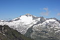
 The west side of the Hochalmspitze seen from the Hannoverhaus , to the left of the summit the Großelendkopf above the Großelendkees |
||
| height | 3360 m above sea level A. | |
| location | Carinthia , Austria | |
| Mountains | Ankogel Group | |
| Dominance | 45.6 km → Great Wiesbachhorn | |
| Notch height | 946 m ↓ Niederer Tauern | |
| Coordinates | 47 ° 0 '57 " N , 13 ° 19' 17" E | |
|
||
| rock | Granite , orthogneiss | |
| First ascent | August 15, 1859 by Paul Grohmann , Andreas Pucher vlg. Lenzbauer, Franz Moidele | |
| Normal way | Rudolstädter Weg ( I ) | |
| particularities | Highest mountain in the Ankogel group | |

The Hochalmspitze (formerly also Hochalpenspitze ) is at an altitude of 3360 m above sea level. A. the highest point in the Ankogel group in the Hohe Tauern . As a counterpart to the Glockner , it is also called "Tauern Queen" or "Tauern Princess". It is popularly called Der Hochalmer . It is located east of Mallnitz in Carinthia .
location
The Hochalmspitze has two peaks, the lower Schneeige Hochalmspitze is already gapped out and the higher Apere Hochalmspitze carries the summit cross. In the past, the Großelendkopf, now regarded as an independent summit, was also regarded as the summit of the Hochalmspitze. Between the four distinctive ridges lie the Großelendkees glaciers in the north, Hochalmkees in the east and the smaller Trippkees in the south and Winkelkees in the west.
In the south the Mallnitzer Scharte ( 2673 m ) separates the Hochalmspitze from the Reisseckgruppe and in the north lies the Kölnbreinspeicher . The main ridge to the Ankogel continues to the northwest .
Routes
The normal route leads from the Gießener Hütte over the southeast ridge ("Rudolstädter Weg") ( UIAA I , partially insured). This path was first walked in 1892 by Fritz Kordon and his companions.
The well-known long and more difficult (UIAA II despite insurance) "Detmolder Ridge" leads over the southwest ridge, the first ascent of which O. Chiari and K. Dürr succeeded in 1877.
history
In the 1970s, a glacier ski area was planned on the Hochalmspitze. In 1988 the Austrian Alpine Association succeeded in acquiring the Hochalmspitze and 7.5 km² of adjoining glacier area at an auction, thereby averting technical development. The purchase price at that time was 1.12 million schillings and was raised by a single major donor.
photos
Hochalmspitze seen from the Reißeck
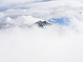
View of the Hochalmspitze from the Schwarzhornsee

View of the Hochalmspitze on the ascent to the Schwarzhorn
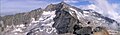
Hochalmspitze from the Schneewinkel peak seen from

Hochalmspitze from Säuleck seen from


literature
- Liselotte Buchenauer , Peter Holl: Ankogel and Goldberg group. A guide to valleys, huts and mountains; written according to the guidelines of the UIAA (= Alpine Club Guide . Central Alps series ). 3rd, completely revised Edition Bergverlag Rudolf Rother, Munich 1986, ISBN 3-7633-1247-1 .
Individual evidence
- ↑ Eberhard Jurgalski : Complete table of summits in the Alps separated by 590 meters of re-ascent , December 12, 2008.
- ^ Malta first ascent of the Tauern Queen. In: bergsteigerdoerfer.org. Retrieved June 28, 2019 .
- ↑ Eduard Richter : The development of the Eastern Alps. III. Volume: The Central Alps east of the Brenner and the southern Limestone Alps. Publishing house of the German and Austrian Alpine Club, Berlin 1894, p. 254 ff.
- ^ Federal Office for Metrology and Surveying Austria: Hochalmspitze on the Austrian Map online (Austrian map 1: 50,000) .
- ↑ Heinz Jung Meier: Heinz Roth (1916-2007). The Hochalmspitze - his legacy for the Alpine Club . In: Uphill. The magazine of the Austrian Alpine Club since 1875 . 3, June – August, 2008 ( alpenverein.at [PDF; accessed on December 5, 2015]).
Web links
- Hochalmspitze on summitpost.org (English)
- Hochalmspitze on Peakbagger.com (English)