
Ankogel
| Ankogel | ||
|---|---|---|
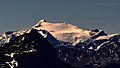
 Ankogel seen from the Auernig |
||
| height | 3252 m above sea level A. | |
| location | Carinthia and Salzburg , Austria | |
| Mountains | Ankogel Group | |
| Dominance | 6.34 km → Großelendkopf | |
| Notch height | 578 m ↓ Großelendscharte | |
| Coordinates | 47 ° 3 '4 " N , 13 ° 14' 55" E | |
|
||
| rock | Amphibolite , eclogite | |
| First ascent | 1762 by a farmer Patschg from Böckstein | |
| Normal way | Alpine tour with climbing (I +) | |

The Ankogel is with a height of 3252 m above sea level. A. the eponymous mountain of the Ankogel group - but not its highest point ( Hochalmspitze , 3360 m ). It is located near Bad Gastein in the border area between Carinthia and Salzburg . Its summit was originally 3263 m above sea level. A. high, but broke off in a landslide on the night of January 6th to 7th, 1932.
The Ankogel was the first glacier peak ever, and one of the first three-thousand-meter peaks , to be climbed from the Anlauftal valley by the farmer Patschg for the first time in 1762. Karl Thurwieser achieved his first tourist ascent with the hunter Chr. Ries on October 17, 1822, repeated by Archduke Johann , Baron Herberts and several guides on August 4, 1826, both times roughly along today's normal route.
The Ankogelbahn lifts from Mallnitz in Carinthia to an altitude of 2636 m .
Routes
- Mountain station Ankogelbahn - Lassacher Kees - Kleiner Ankogel - Ankogel (800 meters in altitude, 3 hours). Shortest ascent, path marked throughout. Between Kleines Ankogel and Ankogel, difficulty I + according to the UIAA scale .
- Böckstein - Anlauftal - Radeckalm - Bleksen - Radeckscharte - Kleiner Ankogel - Ankogel (2100 meters in altitude, 6 to 7 hours, also in winter as a ski route). There is no path between Radeckalm and Radeckscharte , therefore not recommended in summer. Between Kleines Ankogel and Ankogel, difficulty I + according to the UIAA scale .
- Böckstein - Anlauftal - Korntauern - Hannoverhaus - Lassacher Kees - Kleiner Ankogel - Ankogel (2100 meters in altitude, 8 to 9 hours). Trail marked throughout. Between Kleines Ankogel and Ankogel, difficulty I + according to the UIAA scale .
- Kölnbreinspeicher - Osnabrücker Hütte - Ankogel (9.5 hours)
Ankogel from the northeast

Individual evidence
- ↑ Clem Clements, Jonathan de Ferranti, Eberhard Jurgalski , Mark Trengove: The 3000 m SUMMITS of AUSTRIA - 242 peaks with at least 150 m of prominence , October 2011, p. 18.
- ↑ Federal Office for Metrology and Surveying Austria: Ankogel on the Austrian Map online (Austrian map 1: 50,000) .
- ↑ The cradle of alpinism. From the Ankogel to the mountains of the world (Documentary 2012)
- ↑ Liselotte Buchenauer , Peter Holl: Alpine Club Guide Ankogel and Goldberg Group , Bergverlag Rudolf Rother , Munich 1986. ISBN 3-7633-1247-1
Web links
- Ankogel - Hribi.net (Slovenian / English)