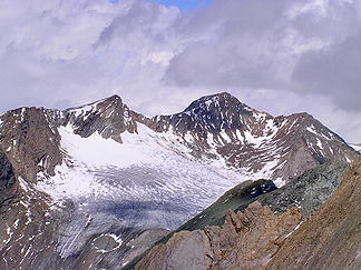
Garnet group
| Garnet group | |
|---|---|
|
Great Muntanitz from the south |
|
| Highest peak | Großer Muntanitz ( 3232 m above sea level ) |
| location | Salzburg and Tyrol , Austria |
| part of | Central Eastern Alps |
| Classification according to | AVE 39 |
| Coordinates | 47 ° 4 ′ N , 12 ° 35 ′ E |
| rock | Tauern window |
| surface | 308.0 km² |
The Granatspitzgruppe is a mountain group in the central Eastern Alps . Together with the Ankogel Group , the Goldberg Group , the Glockner Group , the Schober Group , the Kreuzeck Group , the Venediger Group , the Villgratner Mountains and the Rieserferner Group , the Granatspitz Group forms the large group of the Hohe Tauern . The Granatspitzgruppe is located in Austria in the federal states of Salzburg and Tyrol . The highest peak is the Great Muntanitz , 3232 m above sea level. A.
The Granatspitzgruppe is located in the central part of the Hohe Tauern. The Felbertauernstrasse limits the group largely to the west. The group is somewhat overshadowed by its famous neighboring groups with the Großglockner and Großvenediger . The group is named after the Granatspitze , 3086 m above sea level. A.
Concept history
The concept of an independent garnet group was introduced by Karl Hofmann in 1871 . He rejected the previous membership of the mountains of the Granatspitzgruppe to the Glocknergruppe , which was founded by Adolf Schaubach in 1845, for orographic reasons. The naming by Hofmann as the Landeck group , after the branching point of the group, the Großer Landeggkopf ( 2900 m ), could not, however, prevail within the group due to its not very significant height. As early as 1873 Gustav Demelius therefore introduced the name, which is now widely used, as the Granatkogl group, considering the Granatspitze (then Grantkogl) as the highest peak of the Tauern main ridge within the group.
Neighboring mountain groups
The Granatspitzgruppe borders on the following other mountain groups in the Alps:
- Kitzbühel Alps (in the north)
- Glockner group (in the east)
- Schobergruppe (in the southeast)
- Villgraten Mountains (in the southwest)
- Venediger Group (in the west)
Boundary
In the north, the Oberpinzgau forms the border from Mittersill down the Salzach to Uttendorf . In the east, the border from Uttendorf runs southwards through the Stubach Valley via Enzingerboden, Grünsee, along the Weißenbach and Weißsee to the Kalser Tauern (also Kalser Törl ); from there over the Dorfer lake along the Kalser Bach to the south to the confluence with the Isel near Unterpeischlach. The western border runs up the Isel to Matrei in Osttirol , further along the Tauernbach to the Felber Tauern , further over Langsee, Plattachsee, and Hintersee along the Felberache and the Felbertal to the confluence with the Salzach.
summit
All named three-thousanders (main summit in the Granatspitzgruppe):
- Großer Muntanitz 3232 m above sea level A.
- Kleiner Muntanitz 3192 m above sea level A.
- Upper Muntanitzpalfen 3170 m above sea level A.
- Luckenkogel 3100 m above sea level A.
- Stubacher Sonnblick 3,088 m above sea level A.
- Granatspitze 3086 m above sea level A.
- Vordere Kendlspitze 3085 m above sea level A.
- Rear Kendlspitze 3085 m above sea level. A.
- Kalser Bärenkopf 3,079 m above sea level A.
- Gradötz 3063 u m. A.
- Stellach wall 3060 m above sea level A.
- Gray shimmers 3053 m above sea level. A.
- Corrugated heads 3037 m above sea level A.
- Outer Knappentröger 3031 m above sea level A.
Other important peaks in the course of the main Alpine ridge (from west to east):
- Hochgasser 2922 m above sea level A.
- Bear heads 2863 m above sea level A.
- Teufelspitze 2848 m above sea level A.
- Riegelkopf 2920 m above sea level A.
glacier
The following glaciers are located in the Granatspitz Group:
- Bachtrögerkees
- Daberkees
- Gradötzkees
- Granatspitzkees
- Landeggkees (Knaudl)
- Landeggkees (Stubacher Sonnblick)
- Luckenkees
- Muntanitzkees
- Prägratkees
- Ravenkees
- Sonnblickkees
Individual evidence
- ^ Journal of the German Alpine Club, II, 1870-71, pp. 187-189
- ^ Journal of the German Alpine Club, IV, 1873, pp. 41–46
- ^ Zlöbl: Three thousand meter peaks in East Tyrol p. 170
- ^ Austrian Map
literature
- Clemens M. Hutter: The Granatspitzgruppe - From the blessing of the late development. in: Berg 2003. Alpine Club Yearbook Volume 127, Munich / Innsbruck / Bozen 2003, pp. 10–26.
- Georg Zlöbl: The three thousand meter peaks of East Tyrol in the Hohe Tauern National Park . Verlag Grafik Zloebl, Lienz-Tristach 2007, ISBN 3-200-00428-2 .


