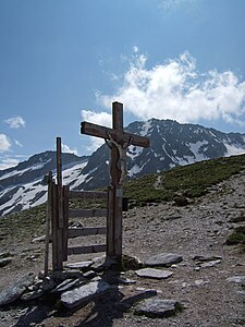
Kalser Tauern
| Kalser Tauern | |||
|---|---|---|---|
|
The Kalser Törl , in the background the Kalser Bärenkogel |
|||
| Compass direction | north | south | |
| Pass height | 2515 m above sea level A. | ||
| state | Salzburg | Tyrol | |
| Watershed | Schrabach | Seebach | |
| Valley locations | Schneiderau | Mocking Taurer | |
| expansion | Mule track | ||
| Mountains | Granatspitzgruppe - Glocknergruppe | ||
| map | |||
|
|
|||
| Coordinates | 47 ° 7 '9 " N , 12 ° 37' 20" E | ||
The Kalser Tauern (also Kalser Törl or Stubacher Tauern ) is 2515 m above sea level. A. high mountain pass over the main Alpine ridge in the Hohe Tauern . The border between East Tyrol and the State of Salzburg runs at the top of the pass .
The Kalser Tauern lies between the Tauernkogel ( 2683 m ) and the Medelzkopf ( 2761 m ) and separates the Granatspitz group from the Glockner group . As a connection between the Kalser Dorfertal and the Stubach Valley , the Kalser Tauern has been an important link between East Tyrol and the Pinzgau for centuries .
The Kalser Tauern can be reached from East Tyrol via the Kalser Tauernhaus , from Pinzgau via the Rudolfshütte on the Weißsee .
history
Today the Kalser Tauern no longer has any special traffic-related significance. It can be reached from the Stubachtal as well as from the Kapruner Tal via the Kapruner Törl ( 2639 m ). The Kalser Tauern opens up both valleys to the Kalser Valley, beyond that to East Tyrol.
It is unclear to what extent the Kalser Tauern was used in Roman and pre-Roman times, but a certain inspection, with the appropriate path conditions, must have existed. There is hardly any other explanation for a legend from the early Middle Ages , which speaks of St. Rupertus , who himself moved across the Kalser Tauern in Carolingian times to found parishes in Kals and Matrei . Since large parts of the Alps and the Tauern were quite depopulated and orphaned at that time, this legend speaks for a sufficient existence of civilization along the Kalsertauernweg. After all, there had to be knowledgeable guides, and at least a passable route.
The Kalser Tauern did not become more important in the Middle Ages either , it was always in the shadow of other Tauern passes. While the Kapruner Weg was only used locally, the Stubacher Weg has a noteworthy regional use. Kals salt carriers, who bought salt from Stubacher farmers or exchanged it for cattle or grain, were the main carriers of traffic. The mule track, which was used by the salt carriers, probably came from the late Middle Ages and was hardly more than a nature trail, the most dangerous parts of which were defused by minor but unplanned expansion. A practice that was the norm on most passes at the time. In a document from 1669 it is soberingly reported that the path was so rough and dangerous that the salt could not be brought across with any horse . Another document from the following year stated that the goods had to be carried on the backs of porters, since it was impossible to get on with horses.
The road conditions neither corresponded to the traffic nor to the already low traffic needs. Improvements to the road that are said to have taken place in the 16th century were, if at all, only of a superficial nature. On the Tyrolean side there were several projects for the construction of a new mule track, around 1576 and 1630. Shortly after the construction of the modern Tauernstrasse, in 1770 they wanted to build a driveway over the Kalser Tauern. In the meantime the Kalser Tauern had long since fallen into insignificance and it was hoped with this project to revalue the once important pass route. All of these attempts were unsuccessful, not one was carried out and the passport remained meaningless. It was not much different when a road construction project was briefly discussed after the First World War .
swell
- ↑ Federal Office for Metrology and Surveying Austria: Kalser Tauern on the Austrian Map online (Austrian map 1: 50,000) .
- ^ Steffan Bruns: Alpine passes - from the mule track to the base tunnel, vol. 4

