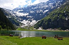
Felbertal
The Felbertal is an alpine side valley of the Salzach Valley in Oberpinzgau ( Salzburg ).
The Felbertal was formed by the Felber Bach and extends from Mittersill to the Felber Tauern , an old pass crossing. The name comes from the noble family of the Lords of Felben . The Altweg will have led along the Tauernbach , today the Felbertauernstraße crosses under the pass in the side valley of the Amerbach .
From an economic point of view, the Felbertal is also significant due to the mining of the mineral scheelite for the extraction of tungsten . The 380 kV line from Kaprun to Lienz has been running through the valley since 1975 .
In the Hintertal of the Felbertal lies the Hintersee at an altitude of 1313 m . This natural monument was formed in 1495 by a landslide . A nature trail from the Hohe Tauern National Park leads to the lake , as does a narrow road. Other special features are the Schößwendklamm , the Pembach waterfall , the Schleierfall of the Tauernbach from the Geißstein am Hintersee, and the Karseen Plattachsee at 2199 m in the Felberbach valley head, Langsee and Tauernsee (Obersee) in the Tauernbach valley head
The Hintersee is also the starting point for hikes to the three cirque lakes and on to the St. Pöltner Hütte of the ÖAV on the Felber Tauern, from where a path leads to the Tauernkogel ( 2988 m ). The refuge is the junction for the high alpine trails St. Pöltner Ostweg and St. Pöltner Westweg , which continue along the Alpine ridge to today's Berghotel Rudolfshütte and the Neue Prager Hütte .
Web links
- Entry on Felbertal in the Austria Forum (in the AEIOU Austria Lexicon )
Individual evidence
- ↑ a b Mittersill - Hintersee and Plattachsee. Hike, on bergfex.at (September 22, 2009).
Coordinates: 47 ° 11 ′ 31 ″ N , 12 ° 28 ′ 30 ″ E

