
Kreuzeckgruppe
| Kreuzeckgruppe | |
|---|---|
 Overview map of the Kreuzeck group |
|
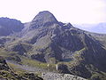
 Polinik from the north |
|
| Highest peak | Polinik ( 2784 m above sea level ) |
| location | Carinthia and Tyrol , Austria |
| part of | Central Eastern Alps |
| Classification according to | AVE 43 |
| Coordinates | 46 ° 50 ' N , 13 ° 8' E |
| rock | Old crystalline |
| surface | 605.4 km² |
The Kreuzeck Group is a mountain group in the central Eastern Alps . Along with the Ankogelgroup , the Goldberg Group , the Glockner group , the Schober Group , the Granatspitzgruppe , the Venice Group , the Villgraten mountains and Rieserfernergruppe the Kreuzeckgruppe forms the largest group of Hohen Tauern . The Kreuzeck Group is located in Austria in the federal states of Tyrol and Carinthia . The proportion of Tyrol is limited to a small tip in the west of the group.
The highest peaks are Polinik ( 2784 m above sea level ), Striedenkopf ( 2749 m above sea level ), Hochkreuz ( 2709 m above sea level ) and Kreuzeck ( 2701 m above sea level ). The Kreuzeck group is mainly made up of gneiss and mica schist ; geographically it is bounded by the Mölltal in the north and the Oberdrautal in the south . To the west, the Iselsberg limits it to the Schober group .
The Kreuzeck group covers an area of 605.4 km², which is hardly populated and is used for alpine pasture and forestry.
In the Mölltal and Kolbnitz there are reservoirs of the power plants Fragant and Reisseck-Kreuzeck . The Raggaschlucht is worth seeing . Towards the Drau Valley there is the small Emberger Alm ski area .
Neighboring mountain groups
The Kreuzeck group borders the following other mountain groups in the Alps:
- Goldberg Group (in the north)
- Ankogel Group ( Reisseck Group ) (in the northeast)
- Gailtal Alps (in the south)
- Schobergruppe (in the northwest)

Kreuzeck with Glanzsee and Feldnerhütte
Hochtristen with Einsee

View from Kolbnitz towards the Kreuzeck group
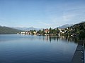
View from Millstatt towards the Kreuzeck group

View from Mirnock towards the Kreuzeck group


literature
- Manfred Posch : Reißeck, Kreuzeck. The most beautiful tours, Klagenfurt 2000, Kärntner Druck- und Verlagsgesellschaft mbH, ISBN 3-85391-176-5
- Rudolf Gritsch: Little Leader Kreuzeck, Reisseck and Sadnig Group. Rother-Verlag, Munich 1977, ISBN 978-3-7633-3243-4
Web links

(from west to east)
Venediger Group |
Rieserferner Group |
Villgraten Mountains |
Garnet group |
Glockner Group |
Schobergruppe |
Goldberg Group |
Kreuzeckgruppe |
Ankogel Group
Ankogel Group | Glockner Group | Goldberg Group | Garnet group | Gurktal Alps | Kitzbühel Alps | Kreuzeckgruppe | Lavantal Alps | Oetztal Alps | Radstädter Tauern | Prealps East of the Mur | Rätikon | Rieserferner Group | Rottenmanner and Wölzer Tauern | Samnaun group | Sarntal Alps | Schladminger Tauern | Schobergruppe | Seckauer Tauern | Sesvenna group | Silvretta | Stubai Alps | Tux Alps | Venediger Group | Verwall | Villgraten Mountains | Zillertal Alps