
Tux Alps
| Tux Alps | |
|---|---|
 Overview of the mountain group and their location within the Eastern Alps |
|
| Highest peak | Lizumer Reckner ( 2886 m above sea level ) |
| location | Tyrol |
| part of | Central Alps |
| Classification according to | AVE 33 |
| Coordinates | 47 ° 11 ' N , 11 ° 39' E |
The Tux Alps (also known as the Tux Pre-Alps ) are a mountain group in the central Eastern Alps . You are entirely in Austria in the state of Tyrol . They are one of three mountain groups that make up the mountain ranges of the city of Innsbruck . The highest peak is the Lizumer Reckner , 2886 m above sea level. A. , between the Wattentaler Lizum and the Navistal .
About the name
It is named after the Tuxbach (medieval Tukkes ), which borders the mountain group to the south and also gave its name to the Tuxertal , a side valley of the Zillertal , as well as the municipality of Tux .
In the Alpine Club division of the Eastern Alps (AVE) , the mountain group described here is referred to as the Tux Alps .
The name Tuxer Voralpen comes from the Alpine divisions of the 19th century: Originally, the Tuxer Alps comprised the mountains up to the Zemm- / Zamser Grund , the southern source valley of the Zillertal branching off near Mayrhofen , and over to the Pfitscher valley , as a subgroup of the Zillertal Alps . And this group, like most of the mountain groups in the area, was named after the most important valley that penetrated the core of the group. The ridge between the Zamser- and Tuxertal is the Tuxer Kamm , at that time the Tuxer Hauptkamm , and the highest peak in the Tuxer Alps was the Olperer at 3480 m. This train was added by Böhm in 1887
due to its geology and altitude to the - by him reduced - Zillertal Alps. The mountain group lost its main chain, the remainder was called Tuxer Tonschiefergebirge by Böhm , as a geologically correct part of the Salzburg Slate Alps , which refers to the slate of the Grauwackenzone of the Alps between central gneiss and limestone (mountains means in the technical language of mining Rock , Böhm was concerned with a geologically precise classification). From Moriggl it was in 1923 because of its bulky name (his concern was mountaineering) landesüblich in Tux Alps renamed, in the sense, lower mountains to Tux '- the expression foothills means the Tirolean the height level between the Central Mountains and the high mountains (the actual Alps ) . Since then, however, the pre-Alps have been given a different meaning and are identified with the edge-alpine upstream chains - located in front of the Alps . For this reason, the term “ Voralpen” , which has meanwhile been misunderstood, was left out
when Graßler revised it
, so that the mountains have their original name again, but no longer the original extension that gave them this name.
location
Neighboring mountain groups
The Tux Alps border the following other mountain groups in the Alps:
- Karwendel (in the north)
- Rofan Mountains (in the northeast)
- Kitzbühel Alps (in the east)
- Zillertal Alps (in the south)
- Stubai Alps (in the west)

Boundary
In the north, the Lower Inn Valley forms the border from Innsbruck downstream to the confluence of the Ziller . The Zillertal limits the mountain group in the east from the confluence of the Ziller into the Inn upstream to Mayrhofen . In the south, the Tuxertal forms the border from Mayrhofen to Hintertux. From there the border continues to the Tuxer Joch and through the Schmirntal to Sankt Jodok . In the west, the Tux Alps are bounded by the Wipptal from Sankt Jodok downstream to Innsbruck.
The Tuxer Joch connects the Tux Alps with the Zillertal Alps.
Important mountain peaks
- Lizumer Reckner , 2886 m
- Vulture , 2857 m
- Kalkwand , 2826 m
- Rosenjoch , 2796 m
- Rastkogel , 2762 m
- Malgrübler , 2749 m
- Hirzer , 2725 m
- Glungezer , 2677 m
- Gilfert , 2506 m
- Grüblspitze , 2395 m
- Kellerjoch , 2344 m
- Patscherkofel , 2246 m
geology

The largest part of the Tux Alps consists of low-grade metamorphic rocks that belong to the Innsbruck quartz phyllite complex (quartz phyllite slate). A zone of different Mesozoic rocks, the Tarntal Mesozoic, adjoins this zone of paleozoic rocks to the south . Like the quartz phyllite zone, this complexly structured zone belongs to the tectonic unit of the Lower Eastern Alps . In the Tarntal Mesozoic, there are dolomites and limes , for example, which build up the limestone wall or the goal wall in the area of the Wattentaler Lizum. On the other hand, there are also components of former ocean floors which, as serpentinite, build up the Lizumer Reckner. The southern edge of the Tux Alps belongs to the tectonically lower-lying Penninic Tauern window . As far as the Tux Alps are concerned, there are mainly rocks from the Penninic Glockner ceiling (limestone mica slate shell of the Tauern). The north-eastern corner of the Tux Alps in the Schwaz to Fügen area in the Zillertal belongs to the Upper Eastern Alpine Grauwackenzone , which consists of paleozoic rocks. In the Schwaz area, large amounts of silver and copper were mined in this zone in the past . The terraces on the edge of the Inn valley, the Tyrolean low mountain range , are a periglacial rubble landscape that is also rich in glacial morphological phenomena, such as remains of dead ice .
Development
The Tux Alps are a ski touring and hiking area .
Ski areas
Ski areas are Glungezer , Lizum im Wattental , Hochfügen-Hochzillertal , Penken and Kellerjoch , Patscherkofel .
Huts

The following huts of alpine clubs are located in the Tux Alps:
- Glungezerhütte
- Kellerjochhütte
- Lizumer hut
- Meissner house
- Naviser Hut
- Patscherkofelhaus
- Rastkogelhütte
- Tuxerjochhaus
- Vinzenz Tollinger Hut
- Voldertalhütte
- Weertal Hut
- Weidener Hut
Long-distance and long-distance hiking trails
The dream path Munich-Venice also leads through the Tux Alps. This is not an official long-distance hiking trail . The route, which was proposed for the first time in 1977, has become more well known than some of the long-distance hiking trails created by hiking associations or states.
The 9th day of the dream path leads from Hall in Tirol to the Glungezerhütte , the next stage over the seven tuxer summits and the Naviser Jöchl to the Lizumerhütte of the OeAV Hall.
The 10th or 11th day leads from the Lizumerhütte to the Tuxerjochhaus , over the Pluderling saddle and the Gschützspitze saddle.
The Adlerweg , Via Alpina (red), Olympiaweg , Glungezer & Geier-Weg 335 , and Zentralalpenweg 02A also lead through the Tux Alps .
Web links
Individual evidence
-
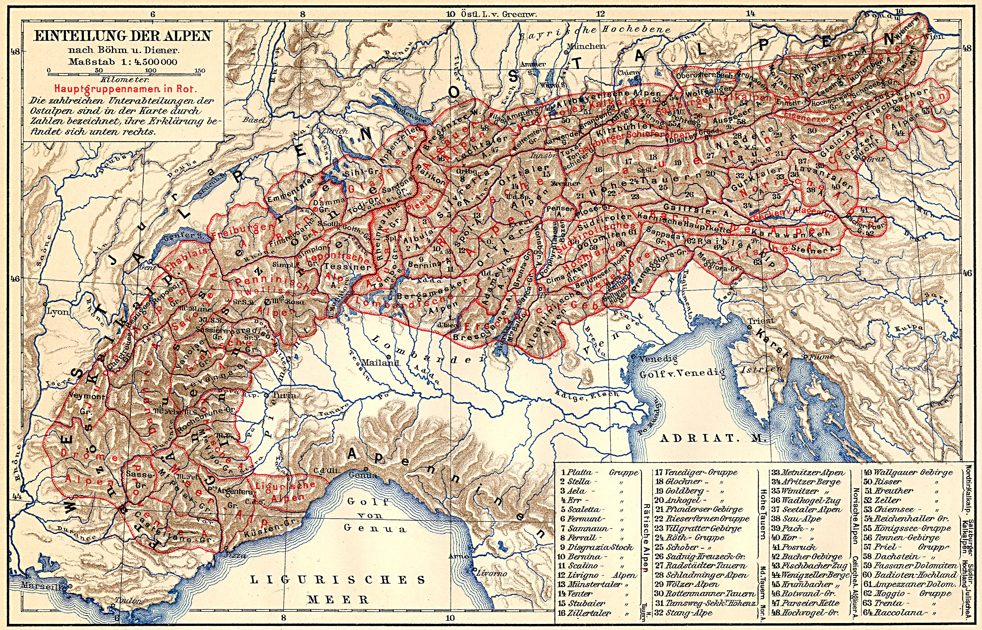
↑ a b August von Böhm : Classification of the Eastern Alps . In: A. Penck (Ed.): Geographische Abhandlungen . tape 1 . Eduard Hölzel, Vienna 1887 (1 multicolored map 1: 1,000,000). Revised Carl Diener : The Mountain Construction of the Western Alps . Tempsky / Freytag, Prague 1891.
Used for example: Alps . In: Meyers Großes Konversations-Lexikon . 6th edition. tape
1 . Leipzig 1905, 2nd geographic division of the Alps. Eastern Alps. 3) The Tauern starting east of the Brenner ... , p. 361–369 (364) ( zeno.org - classification according to Böhm and Diener, map 1: 4,500,000 ). - ↑ See Verwall group after the Verwall (valley) , Stubai Alps after the Stubai (valley) , or historically Vermunt group after the Vermunt
- ^ Ernst Höhne : The Alps between Chiemsee and the Dolomites . In: Knaurs Lexikon für Bergfreunde . tape 4 . Droemer Knaur, Munich 1986, ISBN 3-426-26222-3 , pp. 285 .
-
↑ a b The Zillertal Alps themselves also share their careers: These originally also comprised all mountains to the left and right of the Zillertal. Since the former are now the Tux Alps and the latter are part of the Kitzbühel Alps, the Zillertal (in the true sense, to Mayerhofen) is no longer in the Zillertal Alps, but separates Tux from Kitzbühel.
For several other groups, the original eponymous valley is no longer the core valley, such as the Ötztal Alps and Lechtal Alps . - ↑ The Zillertal, as well as the valleys of the Tiroler Ache around Kitzbühel, had not belonged to Austria, but to the Archdiocese of Salzburg (the latter still belong to the Salzburg Diocese ). Therefore, even in the late 19th century, it was still quite natural to view the Tux Alps as a continuation of a largely Salzburg mountains protruding into the Tyrol.
- ^ Josef Moriggl: From hut to hut: Guide to the refuges in the Eastern Alps . Ed .: D. u. Ö. Alpine Club. 1st edition. 1923.
- ↑ the name Alps (sic) for the altitude level above about 2000 m (subalpine and above, i.e. today's concept of high mountains), in contrast to a lowermost wooded part , was coined by the Swiss Johann Georg Sulzer in 1745.
- ↑ In the 1970s and 80s, the usage was quite inconsistent, for example the International Hüttenatlas '79 / 80 of the DSV (publ. Deutscher Skiverband, Freunde des Skilaufs, 3rd edition. Geobuch-Verlag, Munich 1979, ISBN 3- 920397-00-2 ) in the chapter on the huts (No. 33, p. 210–211) Tuxer Voralpen , but the map (groups 33–39, p. 60/61) is labeled with Tuxer Alpen (and with Tuxer Prealps headed ). This runs through the entire alpine literature of the time and can still be found today.
- ↑ Franz Graßler : Alpine Association Division of the Eastern Alps (AVE) . Alpine Club Yearbook. In: DAV , OeAV , AVS (ed.): Berg '84 . tape 108 , 1984, pp. 215-224 .
- ↑ Rainer Brandner u. a .: Overview of the results of the geological preliminary exploration for the Brenner Base Tunnel in Geo.Alp, Vol. 5, pp. 165–174, Innsbruck 2008.
- ^ Tirol Atlas, Geological overview map of Tirol 1: 300,000, draft: Rainer Brandner.
- ↑ Adlerweg ( Memento of the original from October 9, 2007 in the Internet Archive ) Info: The archive link was automatically inserted and not yet checked. Please check the original and archive link according to the instructions and then remove this notice.
Ankogel Group | Glockner Group | Goldberg Group | Garnet group | Gurktal Alps | Kitzbühel Alps | Kreuzeckgruppe | Lavantal Alps | Oetztal Alps | Radstädter Tauern | Prealps East of the Mur | Rätikon | Rieserferner Group | Rottenmanner and Wölzer Tauern | Samnaun group | Sarntal Alps | Schladminger Tauern | Schobergruppe | Seckauer Tauern | Sesvenna group | Silvretta | Stubai Alps | Tux Alps | Venediger Group | Verwall | Villgraten Mountains | Zillertal Alps