
Mayrhofen
|
market community Mayrhofen
|
||
|---|---|---|
| coat of arms | Austria map | |
 |
|
|
| Basic data | ||
| Country: | Austria | |
| State : | Tyrol | |
| Political District : | black | |
| License plate : | SZ | |
| Surface: | 178.64 km² | |
| Coordinates : | 47 ° 10 ' N , 11 ° 52' E | |
| Height : | 633 m above sea level A. | |
| Residents : | 3,937 (January 1, 2020) | |
| Population density : | 22 inhabitants per km² | |
| Postal code : | 6290 | |
| Area code : | 05285 | |
| Community code : | 7 09 20 | |
| NUTS region | AT335 | |
| UN / LOCODE | AT MRH | |
| Address of the municipal administration: |
Hauptstrasse 409 6290 Mayrhofen |
|
| Website: | ||
| politics | ||
| Mayoress : | Monika Wechselberger ( For Mayrhofen ) | |
|
Municipal Council : (2016) (15 members) |
||
| Location of Mayrhofen in the Schwaz district | ||
  |
||
 The village square of Mayrhofen |
||
| Source: Municipal data from Statistics Austria | ||

Mayrhofen is a market town with 3937 inhabitants (as of January 1, 2020) in the Zillertal and belongs to the Schwaz district in Tyrol ( Austria ). The community is located in the judicial district of Zell am Ziller . Mayrhofen is known today as a winter sports destination for alpine skiing .
geography
Mayrhofen is located in the rear of the Zillertal, east of the Ziller or the Zemmbach , at the end of the valley, where several side valleys or "grounds" come together: Zemmtal , Stilluptal , Zillergrund and the Tuxertal . The municipal area includes the Ochsner ( 3107 m ), Zsigmondyspitze ( 3089 m ), Floitenturm ( 2805 m ) and on the border with Italy the Großer Löffler ( 3379 m ), all in the Zillertal Alps . The Berliner Hütte is on the municipal boundary .
Mayrhofen is the fourth largest municipality in Tyrol in terms of area. It consists of the districts of Straß, Hollenzbrücke, Dorf-Haus, Edenlehen, Hochstegen, Rauchwald, Kumbichl, Dornau, Laubichl, Durst, Hollenzen, Eckartau and Ginzling . Some of these are far apart.
Ginzling has a special statute for Tyrol: the part to the right of the Zemmbach belongs to Mayrhofen, the part to the left of it (Dornauberg) to Finkenberg . Ginzling has its own local committee with a local mayor.
Neighboring communities
Neighboring communities are Ahrntal ( South Tyrol ), Brandberg , Finkenberg , Ramsau im Zillertal and Schwendau .
climate
|
Average monthly temperatures and rainfall for Mayrhofen
|
|||||||||||||||||||||||||||||||||||||||||||||||||||||||||||||||||||||||||||||||||||||||||||||||||||||||||||||||||||||||||||||||||||||||||||||||||||||||||||||||||||||||||
history
The first settlers in the Mayrhofen area probably came from the south over the yokes. They coined the pre-Germanic names like Ziller, Stillupp, Tux, Zemm and Floite. The name Mayrhofen goes back to an episcopal farm . The place was first mentioned in a document around 1200 in a land register of the Archbishopric of Salzburg. Until 1801 Mayrhofen belonged to the main team Pramberg, today's Brandberg , from then on it appears as an independent main team, from which the municipality of Mayrhofen developed over time. In 1816, after the Congress of Vienna , Mayrhofen, like the rest of the Zillertal valley in Salzburg, became part of Tyrol. In 1837 427 Zillertal Protestants ( Zillertal Inclinants ) had to leave their homeland, including many Mayrhofen families.
Tourism developed with the Berliner Hütte , opened in 1879 , which was soon to be followed by other refuges in the Zillertal Alps. The Zillertalbahn , which opened in 1902, provided another impetus . The thousand-mark block caused a sharp drop in the number of overnight stays. Erich Kästner spent three months in the village in 1945 and saw the end of the war there. He recorded his experiences in Mayrhofen in his book Notabene 45 .
The construction of lifts (Penkenbahn in 1954, Ahornbahn in 1969) allowed Mayrhofen to grow into an internationally known holiday resort.
In 1969 Mayrhofen was raised to a market town. In 1973 the municipality was awarded the “Flag of Honor of the Council of Europe” in Strasbourg. In 1989 she was awarded the “Badge of Honor” by the Council of Europe. Mayrhofen received a valuable award from the Austrian Association of Municipalities in 1980 for exemplary care for the environment and the townscape. As a founding member of the 1st European Partnership Ring, Mayrhofen is on friendly terms with the cities of Cabourg (France), Bad Mondorf (Luxembourg), Chur (Switzerland), Terracina (Italy) and Bad Homburg (Germany) and since 1947 it has been used for learning the German language held international university language courses in cooperation with the University of Innsbruck.
Various advanced training courses for anesthetists take place regularly in Mayrhofen, for example the Repetitorium Anaesthesiologicum, which is why the location is used as a synonym for this advanced training event in these specialist groups.
Population development

Culture and sights
The new Ahornbahn , which went into operation in December 2006, is the largest aerial tramway in Austria with its 160-passenger cabins. The Schneekarhütte, a pyramid-shaped building on the Horberg at an altitude of 2250 m above sea level, should also be mentioned. A. The Hausererschanze is the home hill of the former top jumper Martin Höllwarth .
Between 1990 and 1993, all four episodes of the series Die Piefke-Saga by Felix Mitterer were filmed in Mayrhofen and the surrounding area. In the series, however, the place is called "Lahnenberg".

Mayrhofen from a bird's eye view (2017)
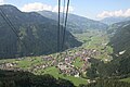
Mayrhofen from the Ahornbahn (2009)

The municipal office of Mayrhofen

Roman Catholic Parish Church of the Assumption
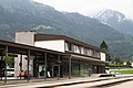
Zillertal Railway station

Europahaus

.jpg)


Economy and tourism
Winter, summer and congress tourism (Europahaus) provides around 1.3 million overnight stays annually and makes Mayrhofen the second most popular tourist destination in Tyrol. In Mayrhofen, the Penkenbahn is the entrance to the Ski Zillertal 3000 winter sports area . Corresponding infrastructure in the retail, commercial and service sectors is connected to it. Mayrhofen has developed into a lively winter sports region since the 1960s, with pubs, bars and après-ski aimed primarily at young adults. Mayrhofen now has 35 hotels and numerous guest houses, holiday apartments and apartment houses as well as several restaurants and pubs.
The Stillup weekly storage facility and the power house in Mayrhofen demonstrate the importance of the location for the energy industry.
traffic
Mayrhofen can be reached via the Zillertalstrasse B169, which branches off the Inntalautobahn A12 at Wiesing . The place is also the terminus of the Zillertal Railway from Jenbach . Mayrhofen is the starting point for the Penkenbahn and Ahornbahn .
Several bus routes run from Mayrhofen train station to the side valleys of the Zillertal as well as to Jenbach and on to Innsbruck
Partnerships
-
 Bad Homburg vor der Höhe ( Germany )
 -
 Bad Mondorf ( Luxembourg )
 -
Bad Tölz ( Germany )
-
 Cabourg ( France ), Normandy region , since 1956
 -
 Chur ( Switzerland )
 -
 Terracina ( Italy )
Sons and daughters
- Hannes Apfolterer (* 1965), clarinetist, composer and military bandmaster
- Alfred Eberharter (* 1951), musician (Schürzenjäger) and painter
- Johannes Geisler (1882–1952), Bishop of the Diocese of Brixen 1930–1952
- Peter Habeler (* 1942), extreme mountaineer
- Albin Moroder (1922–2007), sculptor
- Uli Spieß (* 1955), former ski racer
- Peter Steinlechner (* 1953), band leader of the Schürzenjäger
- Franz Hausberger (* 1919), Mayor 1968–1986
Web links
- History-Tyrol: Mayrhofen
- 70920 - Mayrhofen. Community data, Statistics Austria .
Individual evidence
- ↑ Erich Kästner: Notabene 45. In: Der Spiegel . No. 35 , 1961 ( online ).
- ↑ http://www.mayrhofner-bergbahnen.com
- ↑ Harakiri on the slope. In: Spiegel Online. January 5, 2012, accessed November 29, 2014 .
Achenkirch | Aschau im Zillertal | Brandberg | Bruck am Ziller | Book in Tyrol | At the Achensee | Finkenberg | Joining | Fügenberg | Gallzein | Gerlos | Gerlosberg | Hainzenberg | Hart in the Zillertal | Hippach | Jenbach | Kaltenbach | Mayrhofen | Pill | Ramsau im Zillertal | Ried im Zillertal | Rohrberg | Schlitters | Schwaz | Schwendau | Stans | Steinberg am Rofan | Strass im Zillertal | Mute | Stummerberg | Terfens | Tux | Uderns | Vomp | Weer | Weerberg | Wiesing | Zell am Ziller | Zellberg