Zillergrund
| Zillergrund | ||
|---|---|---|
|
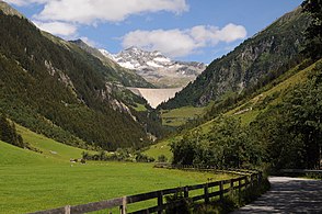
The Zillergrund with the dam of the Zillergründl reservoir |
||
| location | Tyrol , Austria | |
| Waters | Ziller | |
| Mountains | Zillertal Alps | |
| Geographical location | 47 ° 9 ' N , 11 ° 58' E | |
|
|
||
| Type | V valley | |
| height | 600 to 2200 m above sea level A. | |
| length | 20 km | |
The Zillergrund is a 20 km long side valley of the Zillertal in the Zillertal Alps in Tyrol . The valley through which the upper reaches of the Zillers flow is the easternmost of the “inner grounds” into which the Zillertal at Mayrhofen branches out like a fan. The valley largely forms the municipality of Brandberg . The top section is called the Zillergründl .
geography
The valley stretches from Mayrhofen ( 633 m above sea level ) in an easterly to south-easterly direction to the Reichenspitz group and the Zillertal main ridge , where there is a high-alpine transition into the Ahrntal via the Heilige Geistjöchl ( 2658 m above sea level ) . To the south branch off three smaller side valleys with the ground , the Sundergrund and the Hundskehle . The Gerlos group with the Brandberger Kolm ( 2700 m above sea level ) separates the Zillergrund from the Gerlostal in the north, the Ahornkamm with the Ahornspitze ( 2973 m above sea level ) from the southwestern Stillupgrund .
nature
The Zillergrund is a deep indented valley that only has a flat valley floor in a few places . On the southern side of the valley , the coniferous forest, consisting mainly of spruce , extends to the valley floor. The north slopes are also wooded below the accompanying terrace , on the terraces and above there are fields and pastures. It includes coniferous forest with spruce and Scots pine , followed by bushes of juniper , Sebenstrauch and green alder . The southern side of the valley is part of the Zillertal and Tux main ridge quiet area .
Together with the Ahrntal, the Zillergrund is an important migration route across the main Alpine ridge for numerous species of birds, including wood pigeons , cuckoos , swifts , hoopoes , barn swallows and jackdaws .
Settlement and development
In the 12th century ( late Middle Ages ) the valley was cultivated and the first Schwaighöfe were built, from which the village of Brandberg developed, which is located on a terrace around 250 m above the Ziller near the valley exit . Further into the valley there are only a few scattered houses , individual farms and alpine pastures , which also belong to the community of Brandberg. In the uppermost valley section extends to 1850 m above sea level. A. the approximately 3 km long Zillergründl reservoir . A state road leads to Brandberg, the L330 Brandbergstraße , the inner valley is accessed by a toll road.
Web links
- Zillergrund in the Tirol Atlas of the University of Innsbruck
Individual evidence
- ^ A b Günther Bodenstein: Spring observations in the Zillergrund. In: Monticola - Organ of the International Working Group on Alpine Ornithology 2 (1970), pp. 65–71 ( PDF; 512 kB )
- ↑ Tyrolean protected areas: Zillertaler- and Tuxer Hauptkamm quiet area


