Maple tip
| Maple tip | ||
|---|---|---|
|
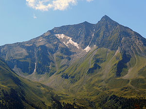
Northern flank of the Ahornspitze |
||
| height | 2973 m above sea level A. | |
| location | Tyrol , Austria | |
| Mountains | Zillertal Alps | |
| Dominance | 4.1 km → Grundschartner | |
| Notch height | 283 m ↓ Scharte to Wilhelmer | |
| Coordinates | 47 ° 7 '45 " N , 11 ° 55' 4" E | |
|
|
||
| First ascent | documented ascent: Peter Karl Thurwieser , Martin Seisl, Joseph Weinold, Joseph Thaler, Joseph Eberharter (guide) and Vitus Kreidl (porter) | |
| Normal way | Marked trail over the west ridge | |
The Ahornspitze is a 2973 m high mountain in the Zillertal Alps , southeast above Mayrhofen ( Tyrol , Austria ). The Ahornspitze has two peaks, the north summit with 2960 m and the south summit with 2973 m , with the summit cross on the lower north summit. The mountain is not glaciated , only on the eastern flank there is currently a steeply sloping firn field called Schneekarl. The neighboring summit in the course of the south ridge is the Popbergspitze ( 2891 m ). To the east, the terrain drops over the Lahnkar to the Bodengrund , a side valley of the Zillergrund . To the north, the Ahornspitze connects directly to the Zillergrund via several cirques , to the west the terrain falls over the Popbergkar down into the Stilluptal . The Ahornspitze is therefore in an exposed position at the northern end of the Ahornkamm and is therefore a popular panoramic mountain.
First ascent
The first documented ascent of the Ahornspitze took place on September 1, 1840 by Peter Karl Thurwieser , Mayrhofen assistant priest Martin Seisl, Brandberg vicar Joseph Weinold, teacher Joseph Thaler with the local dairy farmer Joseph Eberharter as mountain guide and Vitus Kreidl as porter. In Thurwieser's report it becomes clear that his mountain guide Eberharter had already climbed the mountain earlier (" Straight up, said the milker, he had come to the summit once, but didn't want to dare "). It is also remarkable that Eberharter went barefoot as a mountain guide.
The ascent of the Ahornspitze in 1840 is considered the first high-altitude tour in the Zillertal Alps, of which news reached the public.
tourism
summer
The Ahornspitze is usually climbed from the Karl-von-Edel-Hütte ( 2238 m ) in 2 to 3 hours. The path leads from the hut to the east up the Föllenbergkar . At about 2750 meters above sea level, it then swings to the southwest ridge and leads over the south to the north summit. According to the literature, the path is easy, only one point between the south and north peaks is secured with a rope and is rated I according to the UIAA scale . On the southwest ridge there is a risk of falling rocks due to loose rock.
Alternatively, it is possible to get to the southwest ridge via the Popbergschneide . This can be reached from the Karl-von-Edel-Hütte by following the Berliner Höhenweg to Popbergschneide or by bypassing the Karl-von-Edel-Hütte from the Filzenkogl above the Filzenalm the Filzenschneid to the Popbergschneide. Longer sections of these routes are rated UIAA I.
The Karl-von-Edel-Hütte can be reached from Mayrhofen in about 4 hours, so that the ascent of Mayrhofen was mostly done as a two-day tour. However, since 1968 a cable car , the Ahornbahn , has been leading from Mayrhofen to Filzenboden at an altitude of 1965 meters. From the mountain station of the railway, the Karl-von-Edel-Hütte can now be reached in 1 to 1½ hours, so that the Ahornspitze can easily be climbed in a day.
The cable car was completely rebuilt in 2006 and now has a maximum capacity of 1200 people per hour. This leads to the great popularity of the Ahornspitze, which in late summer is sometimes done by several hundred hikers a day when the weather is good.
winter
Directly at the mountain station of the Ahornbahn there is a small ski area on the Filzenboden with a few lifts and easy runs. There is also a descent from the Filzenboden down to Mayrhofen, which is covered with snow with snow cannons in the lower areas if necessary .
Literature and map
- Heinrich Klier / Walter Klier : Alpine Club Guide Zillertal Alps , Munich 1996, ISBN 3-7633-1269-2
- Alpine club map 1: 25,000, Zillertal Alps , medium sheet, No. 35/2
swell
- ↑ Federal Office for Metrology and Surveying : Austrian Map 1: 50,000
- ↑ Alpine Club Card No. 35/2 Zillertal Alps, center. 2003
- ↑ Professor Peter Karl Thurwieser: The Ahornspitze in the Zillerthale. Ascent and measured in the year 1840 (PDF; 8.9 MB) in: Neue Zeitschrift des Ferdinandeums für Tirol and Vorarlberg, 7th year (1841), pp. 68–92
- ↑ The development of the Eastern Alps. III. Band, The Central Alps east of the Brenner and the southern Limestone Alps. Publisher of the German and Austrian Alpine Club, Berlin 1894, p. 77
- ↑ Ahornbahn: Largest gondola in Austria ( Memento from September 25, 2011 in the Internet Archive )
Web links
- Ski tour description
- Directions - Ascent from the Ahornbahn via the Edelhütte


