
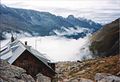
Berliner Höhenweg

The Berliner Höhenweg is a high alpine circular hiking trail in the Zillertal Alps , in the Austrian state of Tyrol , starting from Mayrhofen , which connects numerous huts over a length of about 70 km (projected onto the plain). Today the route is advertised together with the Aschaffenburger Höhenweg as a Zillertaler Runde by the alpine clubs and tourism organizations.
history
When in the second half of the 19th century the interest in the scientific development of the Alps grew and the newly founded, predominantly academic Alpine associations began to build refuge huts with the necessary access routes, the desire arose to have these huts, some of which were very high to connect with each other. Existing hunters and smugglers' paths were often used for this purpose.
In the Zillertal Alps , the Berlin section of the German and Austrian Alpine Club (DuOeAV) was particularly active and built the Berliner Hütte from 1879 onwards . As early as 1889, a high-alpine path over the Schönbichler Horn ( 3,133 m above sea level ) to the then new Furtschaglhaus was completed, which consists of countless, partially processed slabs from the local stones granite and gneiss . The Berlin section commissioned local workers to build this path. This section with a height difference of 1060 meters was the nucleus of the later Berliner Höhenweg.
After the Berlin section had taken over the Olpererhütte and the Rifflerhütte, which had been destroyed since 1945, from the Prague section in 1901 , further high-altitude connecting routes were created. The Friesenberghaus , completed in 1931, was the end point of the route to the northwest for decades from 1945. On the stage from the Olpererhütte to the Furtschaglhaus, the path through the Schlegeisgrund was flooded by the Schlegeis reservoir built in 1965–73 . Plans to build a new path over the Greiner Kamm could not be realized; instead, the path now leads along a driveway along the reservoir. It wasn't until 1968 that the Friesenberghaus- Gamshütte section began . The construction of the 14 km long path through partly difficult terrain, especially in the rockfall endangered gullies southeast of the Hohen Riffler, took eight years. The inauguration ceremony took place in July 1976, according to contemporary witnesses in the cold and snow.
Stages
Stage description and elevation profiles of the route:


- Finkenberg (785 m) - Gamshütte (1916 m)
- The Gamshütte can be reached via the Hermann-Hecht-Weg . Ascent 1000 m, walking time approx. 3 hours
- Gamshütte - Friesenberghaus (2498 m)
- At 14 km, this stage is the longest and most demanding. The path, which runs at an altitude of about 2000 m, is exposed to the southwest, which means maximum solar radiation in midsummer. Hardly used, ascent 1100 m, descent 700 m, walking time approx. 9 hours
- Friesenberghaus - Olpererhütte (2389 m)
- Shortest stage, ascent 150 m, descent 250 m, walking time approx. 2 hours
- Olpererhütte - Furtschaglhaus (2295 m)
- This stage of the trail leads along the Schlegeis reservoir on a road south-east towards Furtschaglboden . Descent 600 m, ascent 500 m, walking time approx. 4 hours
- Furtschaglhaus - Berliner Hut (2040 m)
- At 3133 m, the highest point on the Berlin Höhenweg is reached at Schönbichler Horn . Wire rope insurances are available as climbing aids in the summit area. This stage is partly exposed and demanding. Ascent 900 m, descent 1060 m, walking time approx. 6 hours
- Berliner Hut - Greizer Hut (2226 m)
- Over the Mörchenscharte (2872 m, safety ropes , short ladder) down to the Floitengrund then up to the Greizer Hut. Ascent 1200 m, descent 1100 m, walking time 7 hours
- Greizer Hut - Kasseler Hut (2177 m)
- Over the Lapenscharte , down into the Lapenkar , to the Elsenklamm (rope insurance), fairly flat to the Kasseler Hütte (the path over the Schuhscharte, still marked on some hiking maps, is no longer passable due to a landslide, risk of falling). Ascent 650 m, descent 700 m, walking time 5 hours.
- Kasseler Hut - Edelhütte (2237 m)
- Via the Siebenschneidweg , so called because of the seven ridges to be crossed, 14 km to the Edelhütte, in between a short rope insurance and iron pins as steps at an exposed point. Ascent 800 m, descent 750 m, walking time 9 hours
- Descent to Mayrhofen
- Either with the cable car (Ahornbahn), descent from the Edelhütte 300 m, or on foot over the Föllenbergalpe and the Gasthaus Alpenrose to Mayrhofen, descent 1600 m
conditions
A walk on the path requires surefootedness and a head for heights in high alpine terrain, the ability to orientate yourself, especially in foggy conditions , above-average fitness and appropriate mountain hiking equipment. The indicated walking times are guidelines for dry weather. If it is slippery or wet, a considerably higher expenditure of time must be expected. In the late afternoon, creek crossings can be problematic because more glacier melt water drains off due to the stronger sunlight .
The best time for the Berliner Höhenweg is from mid-July to mid-September. If the weather is good, the huts are open from mid-June to the end of September. However, steeply sloping snowfields can pose dangerous obstacles well into July.

signpost

Friesenberghaus

Olpererhütte

Berlin hut
Kasseler Hut


Hiking maps and literature
- Alpine Club cards 1: 25,000, sheets 35/1 and 35/2
- Heinrich Klier / Walter Klier , Alpine Club Guide Zillertal Alps , Munich, 1996, ISBN 3-7633-1269-2
Web links
- Photo report of the Berliner Höhenweg
- DAV Berlin: leaflet, height profiles, history
- Tour description
- Tour description in the opposite direction - From the Edelhütte to the Gamshütte
Individual evidence
- ^ Website of the DAV
- ↑ year report of the section of the Berlin DuÖ. Alpine Club, 1889
- ↑ Bernd Schröder: 25 years of the Berliner Höhenweg. Website of the DAV section Berlin (PDF, 411 kB)
- ↑ Stages of the way (PDF, 4.5 MB)
- ↑ Elevation profiles of the stages (PDF, 657 kB)