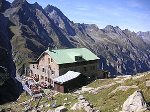
Greizer Hut
| Greizer hut DAV hut category I |
||
|---|---|---|
| location | upper Floitengrund , southeast of Ginzling; State of Tyrol , Austria ; Valley location: Mayrhofen , district of Ginzling | |
| Mountain range | Zillertal Alps | |
| Geographical location: | 47 ° 2 '36 " N , 11 ° 53' 8.5" E | |
| Altitude | 2227 m above sea level A. | |
|
|
||
| owner | DAV - Greiz Section (based in Marktredwitz ) | |
| Built | 1893 | |
| Construction type | hut | |
| Usual opening times | June to September | |
| accommodation | 16 beds, 72 camps | |
| Winter room | 14 bearings | |
| Web link | Website of the section | |
| Hut directory | ÖAV DAV | |
The Greizer Hut is a refuge of the Greiz section (based in Marktredwitz ) of the German Alpine Club and is located at an altitude of 2227 m above sea level. A. in the upper Floitengrund (also called Die Floite ) in the Zillertal Alps , in the Austrian state of Tyrol , southeast above Ginzling , a district of Mayrhofen .
history
The hut was built in 1893 by the Greiz section of the German and Austrian Alpine Club . With the construction of a mule track in 1912, it was possible to improve the previously laborious supply by porters. For many years, the starting point of the Säumerei was in Ginzling and led through the Floite until a driveway created to the Bocknachalm shortened the route to be lined . In 2002 a material ropeway to the hut was built and the supply by the pack animals was discontinued. The hut was expanded in 1905, 1927/28 and in the early 1970s. In 2005 she received the environmental seal of approval for Alpine Club huts .
Approach
- From the Tristenbachalm (here through the Zillertal and via Ginzling) over a goods path and later over a section of the Berliner Höhenweg to the hut. Walking time 4–4½ hours.
- The Greizer Hütte is located on Zentralalpenweg 02 of the OeAV ( Austrian Alpine Association ) and on the Berliner Höhenweg.
Transitions
- Over the Lapenscharte ( 2701 m ) to the Kasseler Hütte with a walking time of 5 hours.
- To the Green Wall House with a walking time of 3 hours
- Via the northern Mörchnerscharte ( 2872 m ) to the Berliner Hütte with a walking time of 6 hours.
- Via the Tribbachsattel ( 3,028 m ) to the Schwarzensteinhütte with a walking time of 3–4 hours
- Descent to the Maxhütte via Mörchen- and Melkerscharte into the Gunggltal .
summit
- Western Floitenspitze ( 3194 m ) with a walking time of 3 hours.
- Großer Löffler ( 3376 m ) with a walking time of 4 hours.
- Schwarzenstein ( 3368 m ) with a walking time of 5 hours
- Gigalitz ( 3002 m ) with a walking time of 2 hours
There is a small climbing garden near the hut .


