Big spoonbill
| Big spoonbill | ||
|---|---|---|
|
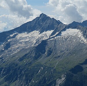
Großer Löffler and to the right of it Kleiner Löffler from the northeast, in front of it the Löfflerkees |
||
| height | 3379 m above sea level A. | |
| location | Tyrol , Austria and South Tyrol , Italy | |
| Mountains | Zillertal Alps | |
| Dominance | 9.3 km → Turnerkamp | |
| Notch height | 368 m ↓ Trattenjoch | |
| Coordinates | 47 ° 1 '57 " N , 11 ° 54' 56" E | |
|
|
||
| rock | granite | |
| First ascent | September 12, 1843 by Markus Vincent Lipold , led by Georg Schneider | |
| Normal way | from the west over the south ridge, glaciated high tour | |
|
Big spoonbill from Gigalitz |
||
The Great Löffler (Italian Monte Lovello ) is a 3379 m above sea level. A. high mountain in the main ridge of the Zillertal Alps on the border between the Austrian state of Tyrol and the Italian province of South Tyrol . Immediately to the north is the Kleine Löffler ( 3225 m ), immediately to the south is the Tribbachspitze (also Trippachspitze , 3271 m ), another secondary peak. The dominant , pyramidal mountain sends pronounced ridges to the west, north, northeast and south, with the southern ridge forming the state border between Austria and Italy. The mountain has got its name since 1840 from the spoonful at its foot . The Italian name Lovello is a phonetic adaptation of the German term and was introduced by the Italian nationalist Ettore Tolomei .
Location and surroundings
The mountain is a good three kilometers as the crow flies southeast of the Floitengrund valley head, 3 to 4 hours' walk above the Greizer Hut . The rock mountain, exposed by its geographical dominance, is surrounded by glaciers . In the north lies the Löfflerkees , in the east the Frankbachkees , in the south the Tribbachkees and in the west finally the Floitenkees . The neighboring peaks are significantly lower, in the north-northeast the Greizerspitze at 3,007 meters, in the east the Keilbachspitze (3,093 m), in the southwest the Ostliche Floitenspitze (Italian: Cima di Floita Est ) with 3,154 meters. Towards the northeastern end of the Stilluppe (also called Stillupptal ), the northeast side of the Großer Löffler slopes down into 600-meter-high rock slabs. To the south the area slopes down to the Ahrntal valley , the closest place is the stone house about six and a half kilometers away .
First ascents
In the literature of the early 19th century, the view was widespread that the Löffler is the highest mountain in Tyrol. The Großer Löffler was first climbed on September 12, 1843 by the mining scientist and geologist Markus Vincent Lipold with the Mayrhofen chamois hunter Georg Schneider as a mountain guide from Ginzling through the Floitengrund over the south ridge , which is still regarded as a normal route (easiest climb). On June 27, 1893, Oscar Schuster from Dresden and the guide Heinrich Moser from Mayrhofen climbed the Kleiner Löffler to the northwest from the Greizer Hütte.
Base and easiest ascent
The Greizer Hut at the end of the Floitengrund at an altitude of 2,226 meters serves as a base for ascent via the normal route from the north, the route of the first climber . It can be reached from Ginzling . From the hut, the path leads south-east to the steep, crevice- rich Floitenkees. The path then runs in an easterly direction south below the west ridge . At the highest point of the glacier between Tribbachspitze and Löffler, it then goes left north over the south ridge to the summit in, according to literature, easy climbing at UIAA level I in a total of 3 to 4 hours of walking to the summit. The normal route from the south leads over a yoke-like depression in the west ridge of the Tribbachspitze, which can be reached from the Schwarzensteinhütte or the Kegelgassenalm via the Tribbachkees. From here either over the ridge crossing the Tribbachspitze or northwest past this to the south ridge of the Großer Löffler.
Literature and map
- Heinrich Klier, Walter Klier : Alpine Association Guide Zillertal Alps , Rother Verlag Munich (1996), ISBN 3-7633-1269-2
- Alpine Club Map 1: 25,000, sheet 35/2, Zillertal Alps, center
Web links
swell
- ↑ Clem Clements, Jonathan de Ferranti, Eberhard Jurgalski , Mark Trengove: The 3000 m SUMMITS of AUSTRIA - 242 peaks with at least 150 m of prominence , October 2011, p. 13.
- ↑ Federal Office for Metrology and Surveying Austria: Großer Löffler on the Austrian Map online (Austrian map 1: 50,000) .
- ^ Egon Kühebacher : The place names of South Tyrol and their history , Volume 3, Athesia, Bozen 2000, p. 93. ISBN 88-8266-018-4
- ^ Carl Diener in Eduard Richter : The development of the Eastern Alps , III. Volume, Berlin 1894, p. 64 ff.
- ^ Markus Vincent Lipold in Kais. Kings priv. Bothen from and for Tyrol and Vorarlberg , Innsbruck 1844, pp. 352, 356, 360, 364 and 368
- ^ Carl Diener in Eduard Richter: The development of the Eastern Alps , III. Volume, Berlin 1894, p. 636
- ^ A b Heinrich Klier, Walter Klier: Alpenvereinsführer Zillertaler Alpen , Munich 1996, p. 285 ff., Margin no. 1420 ff.


