Turnerkamp
| Turnerkamp | ||
|---|---|---|
|
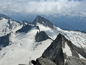
Turnerkamp from the west, from the Großer Möseler |
||
| height | 3420 m above sea level A. | |
| location | Tyrol , Austria and South Tyrol , Italy | |
| Mountains | Zillertal Alps | |
| Dominance | 2.1 km → Großer Möseler | |
| Notch height | 191 m ↓ Rossruggscharte | |
| Coordinates | 46 ° 59 '25 " N , 11 ° 48' 35" E | |
|
|
||
| rock | Central gneiss | |
| First ascent | 1865 by Johann Kirchler | |
| Normal way | through the southwest flank of the Chemnitzer Hütte or the Berliner Hütte as a high tour | |
The Turnerkamp ( Italian Cima di Campo ) is a 3420 m above sea level. A. high mountain in the main ridge of the Zillertal Alps . It lies exactly on the state border between Austria and Italy, or between the federal state of Tyrol and the autonomous province of South Tyrol . It was first climbed in 1865, single-handedly by the local farmer Johann Kirchler from Luttach in the Ahrntal Valley . The first touristic inspection took place on June 25, 1872 by the English climbers from St John's College William Henry Hoare Hudson, Charles Taylor as well as William Martin and Richard Pendlebury, led by Gabriel Spechtenhauser and Georg Samer .
Location and surroundings
The mountain is about eight kilometers as the crow flies north of Lappach in the Lappacher Tal and 12 kilometers south of the Mayrhofen district of Ginzling . Due to its height and size, it has a great geographical dominance . Neighboring peaks are the 3148 m high V. Hornspitze in the east and the Rossruggspitze with 3304 m in the west, separated by the Rossruggscharte ( 3229 m ) . To the north, the Turnerkamp drops over the Hornkees glacier to the Schwarzensteinalpe ( 2050 m ) in the area of the Berliner Hütte , to the south a long south ridge with the Inner Sattelnock (Schneenock) ( 3073 m ) runs down to the Pfaffenscharte at an altitude of 2853 m . This south ridge, known as Sattelschneid , separates the two glaciers, Ostlicher Nöfesferner (located to the west) and the Trattenbachkees located to the east of the ridge . Hornkees is north of the Turnerkamp .
Bases and routes
The route of the English alpinists on June 25, 1872 began at 4 a.m. on the Waxeckalpe and led south over the Waxeggkees , over a notch of the Rossrugg to the upper Hornkees and over the Rossruggscharte south below the west ridge to the summit, which at nine Clock has been reached.
Today's normal route to the Turnerkamp leads through the southwest flank . The starting point here is the Chemnitzer Hütte at an altitude of 2,419 m , above Weißenbach . From the hut, a path marked with cairns leads north over the western lateral moraine of the eastern Nevesferner . Then it goes as an alpine tour , with appropriate equipment and experience, over the eastern area of the glacier past the Turnerkamp south ridge towards Rossruggscharte . Then the tour runs to the right through gutters ( danger of falling rocks ) over the southwest flank in moderately difficult climbing in UIAA grade II steeply to the summit. According to the literature, the walking time is five hours. The Turnerkamp can also be climbed from the Berliner Hut ( 2042 m ). From here a red marked path leads south along the Rossruggen (Rossrücke) up over the upper part of the Hornkees (high tour) to the Rossruggscharte , then as above over the southwest flank to the summit in seven hours according to literature.
Literature and map
- Heinrich Klier, Walter Klier : Alpine Club Guide Zillertal Alps. Rother Verlag, Munich 1996, ISBN 3-7633-1269-2
- Alpine Club Map 1: 25,000, sheet 35/2, Zillertal Alps, middle sheet
- Tabacco-Verlag, Udine, carta topografica 1: 25.000, sheet 036, Campo Tures / Sand in Taufers
Web links
Individual evidence
- ↑ Clem Clements, Jonathan de Ferranti, Eberhard Jurgalski , Mark Trengove: The 3000 m SUMMITS of AUSTRIA - 242 peaks with at least 150 m of prominence , October 2011, p. 11. Height of the reference chart according to: Walter Klier: Alpenvereinsführer Zillertaler Alpen, Munich 2013, RZ 684.
- ↑ Federal Office for Metrology and Surveying Austria: Turnerkamp on the Austrian Map online (Austrian map 1: 50,000) .
- ^ Carl Diener in Eduard Richter : The development of the Eastern Alps , III. Volume, Berlin 1894, p. 38 ff.
- ^ The Alpine Journal , Volume VII, London 1875, p. 49
- ^ Heinrich Klier, Walter Klier: Alpenvereinsführer Zillertaler Alpen , Munich 1996, pp. 271 ff., Rz 1335 ff.


