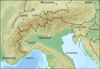
Horn tips
| Horn tips | ||
|---|---|---|
| Highest peak | III. Hornspitz [e] ( 3253 m above sea level ) | |
| location | Tyrol , Austria / South Tyrol , Italy | |
| part of | Zillertal main ridge , Zillertal Alps | |
|
|
||
| Coordinates | 47 ° 0 ′ N , 11 ° 51 ′ E | |
| rock | Central gneiss | |
The Hornspitzen are a multi-peak, up to 3253 m above sea level. A. high floor of the Zillertal Alps , between Zillertal and Ahrntal on the Austrian-Italian border between North and South Tyrol . The highest peak is the III. Hornspitze (3rd Hornspitz, Berlin Lace) .
Location, neighboring mountains, structure and summit

The Hornspitzen rise between the rear Zemmgrund north and the Weißenbachtal south.
They form a section of the Zillertal main ridge . The Trattenjoch (or Innerjoch, approx. 3000) is bordered to the west by the Turnerkamp ( 3418 m above sea level ), a wide mountain range, at the Schwarzenbachscharte ( 3020 m ) to the east by the Schwarzenstein ( 3368 m ) with its secondary peaks.
In the main ridge of the Zillertal Alps lie west to east, with the side ridges:
- Vordere Hornspitze , 3148 m slm , south of Fünfter Hornspitz (Monte Corno) 3145 m slm , ( V. Hornspitze stands for both peaks), with the southward ridge over the joint notch to the jointnock ( 2882 m ) between the upper Weißenbach with Gögenalmbach and Weißenbacher Mitterbach
- VI. Hornspitze , 3198 m above sea level A. respectively the fourth Hornspitz , 3195 m slm ,
- Second Hornspitz , 3221 m slm (or 3222 m slm , II. Hornspitze ). Here the III. Hornspitze (Third Hornspitz, Berlin Peak) , 3253 m above sea level. A. ( 3265 m slm ) as the highest peak of the group of Hornbacks , which runs northwards between Hornkeesbach and the stream of Schwarzensteinkees into the Zemmgrund ( Am Horn 2647 m above sea level )
- I. Hornspitze , 3172 m above sea level. A. ( 3137 m slm ), with the southward Hantigen ridge over Breiten Kopf ( 2855 m slm ), Schwarzenbachtörl to Scharhaggen ( 2645 m slm ), Hantige-Klamm-Spitz ( 2645 m slm , Hantigenklammspitze) and Schafbretterspitz ( 2515 m slm ) to Schönberg ( 2275 m slm ) between Mitterbach and Luttacher Schwarzenbach ; the Mitterbachjoch lies between the II and I Hornspitze
In Italian, all peaks can also be found as I ° to V ° Corno di Ghega
Glaciation
The massif is glaciated on all sides, but not the peaks. The Hornkees , which has now split into two partial glaciers, extends northwest to the Turnerkamp , to the northeast the Schwarzensteinkees , on the south side the Gögenferner , the Mitterbachkees and the Schwarzenbachkees are already in the respective valleys as glacier remains .
natural reserve
On the Austrian side, the group belongs to the Zillertal Alps Nature Park .
Paths and huts
The peaks can be climbed from the north from the Zemmgrund (support point Berliner Hütte ), from the south from Lappach and the Chemnitzer Hütte (Neveser-Joch-Hütte) and Gögenalm , from Weißenbach as well as from Luttach . The climbs follow the valleys or ridges and are at least high alpine .
literature
- Heinrich Klier, Walter Klier: Alpine Club Guide Zillertal Alps. Rother Verlag, Munich 1996, ISBN 3-7633-1269-2 , pp. 247-251.
Individual evidence
- ↑ The name and the Austrian, Italian or unspecified altitude information follows the location according to AMAP / Geonam and TIRS or GeoBrowser Südtirol; The Austrian map writes Roman numerals, the Geonam database Arabic.
- ↑ The national border passes the peaks just 50 meters north below.
- ↑ The respective designated summit lies on both sides of the border.
- ↑ First information GeoBrowser, second Alpine Club map 1: 25,000; the ÖK gives no height.
- ↑ Height information in the GeoBrowser.
- ↑ height information in the GeoBrowser; the national border passes the peaks just under 20 meters south below.
