Zillertal main ridge
| Zillertal main ridge | |
|---|---|
|
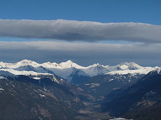
View from Plan de Corones north to the main ridge of the Zillertal |
|
| Highest peak | Hochfeiler ( 3509 m above sea level ) |
| location | Tyrol and Salzburg ( Austria ), South Tyrol ( Italy ) |
| part of | Zillertal Alps |
| Coordinates | 47 ° 1 ' N , 11 ° 52' E |

The Zillertal main ridge is the central ridge of the Zillertal Alps in Tyrol and Salzburg , which runs roughly in an east-west direction. It is part of the main Alpine ridge and forms the watershed between the Danube (to the Black Sea ) and the Adige (to the Adriatic Sea ). Since 1919 the state border between Austria (federal states Salzburg and Tyrol ) and Italy (province South Tyrol ) has run through it .
geography
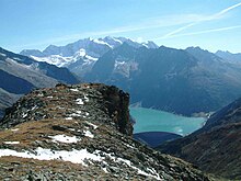
The Zillertal main ridge extends over some 50 km from the Birnlücke in the east to the high wall in the West, where he from the northeast between the Zemmtal and Tux Valley forth pulling Tux ridge meets. Occasionally, the continuation of the main Alpine ridge to the Brenner or south of the Pfitscher Valley to the Trenser Joch is also counted as part of the Zillertal main ridge. Several side ridges branch off to the north , separating the “inner grounds”, the source valleys of the Zillertal . From west to east these are the Hochstellerkamm, Greinerkamm, Mörchen- and Igentkamm, Floitenkamm, Ahornkamm, Riblerkamm and Magnerkamm. On the south side, the main ridge of the Zillertal falls relatively steeply into the approximately parallel upper Ahrntal valley .
The highest peaks in the Zillertal main ridge are:
- Hochfeiler ( 3509 m above sea level ), also the highest peak in the Zillertal Alps
- Großer Möseler ( 3480 m above sea level )
- Hochfernerspitze ( 3463 m slm )
- Turnerkamp ( 3420 m above sea level )
- Großer Löffler ( 3379 m above sea level )
The lowest and most important crossing is the Pfitscher Joch ( 2246 m above sea level ), which leads from the Zamser Grund into the Pfitscher Valley . Other unglaciated crossings are the Hörndljoch ( 2553 m above sea level ), the Hundskehljoch ( 2557 m above sea level ), the Heilige Geistjöchl ( 2658 m above sea level ), the Krimmler Tauern ( 2633 m above sea level ) and the Birnlücke ( 2665 m above sea level ). The north side of the ridge in particular is heavily glaciated, the Schlegeiskees, Schwarzensteinkees , Waxeggkees and Floitenkees are among the largest glaciers . The glaciers on the south side are much smaller and higher.
geology
The main ridge of the Zillertal valley lies mainly in the Tauern window of the central gneiss zone with hard rock. Between the Pfitscher Joch and the Großem Möseler, the surrounding slate shell extends eastwards to the Floitengrund . As in the entire area of the Tauern Window, there are numerous, otherwise sometimes rare minerals such as hematite , rock crystal , smoky quartz , tourmaline , scepter amethyst and garnet in the Zillertal main ridge .
Development
The development of the main ridge of the Zillertal began primarily from the south, where access from the Ahrntal was easier than from the Zillertal. Many of the first ascent were made from the south. In 1873 the Sand in Taufers section of the German and Austrian Alpine Club was founded, which in 1876 built the first refuge on the Zillertal main ridge, the now derelict Sonklarhütte on Speikboden. It was followed by three more huts within a few years.
natural reserve
The entire North Tyrolean part of the main ridge is under protection, since 1991 as a quiet area Zillertaler Hauptkamm , since 2001 as nature park Zillertal Alps . The nature park covers an area of 372 km² and lies at an altitude of 1010 to 3509 m. On the South Tyrolean side, the main ridge in the uppermost Ahrntal is part of the Rieserferner-Ahrn nature park .
literature
- Walter Klier (Ed.): Zillertal Alps. Alpine Club Guide. A guide to valleys, huts and mountains. Bergverlag Rother, Munich 1996, ISBN 978-3-7633-1269-6 , p. 215
Individual evidence
- ↑ Mountain groups and tour regions in South Tyrol , almenrausch.at
- ↑ Zillertal Alps. In: Meyers Großes Konversations-Lexikon, Volume 20, Leipzig 1909, pp. 928–929. ( online )
- ↑ a b Tyrolean protected areas: Zillertaler- and Tuxer Hauptkamm quiet area
- ↑ Gudrun Steger: Alpine history in a nutshell: Ginzling in the Zillertal. Oesterreichischer Alpenverein, Innsbruck 2010 ( PDF; 2.4 MB ( memento of the original from September 23, 2015 in the Internet Archive ) Info: The archive link has been inserted automatically and has not yet been checked. Please check the original and archive link according to the instructions and then remove this notice . )


