
Hydroelectric power plants in the Zillertal
The Verbund AG (former Tauernkraftwerke AG) operates in the Zillertal eight hydroelectric power plants on five reservoirs .
Power plant network
The power plant network with the reservoirs:
- Zillergründl (card name "Speicher Zillergründl")
- Schlegeis reservoir
- Still-up memory (card name "memory still-up")
- Durlassboden storage facility
- Gmünd storage facility
and the power plants:
- Rosshag
- Houseling
- Mayrhofen
- Tuxbach
- Bösdornau
- Gunggl
- Gerlos
- Funsingau
is used to generate electricity , especially during peak load times .
The storage power plants and run-of-river power plants in the Tyrolean Alps have a peak output of around 1,000 megawatts.
Zemm-Ziller power plant group
The power plant group consists of two upper levels, the Roßhag and Häusling pumped storage power plants with the Schlegeisspeicher and Zillergründl reservoirs and the Mayrhofen main stage with the Stillup reservoir. The Stillup reservoir is the reservoir of the Mayrhofen power plant, and at the same time it serves as a withdrawal reservoir for the upper-stage pumped storage power plants in Roßhag and Häusling.
Together with the Gunggl, Bösdornau and Tuxbach power plants, the Zemm-Ziller power plant group has an output of 965 MW plus 600 MW of the pumps in the Roßhag and Häusling power plants. It therefore has an output range of more than 1,500 MW, making it the most powerful storage power plant group in Austria.
Roßhag power station and Schlegeis reservoir

The water from the Schlegeis reservoir flows in a 7.8 kilometer long tunnel to the power plant, and after generating electricity, it flows on to the Stillup reservoir.
| Power plant data: | |
|---|---|
| Power plant type | pumped storage power plant |
| Average Annual production | 313.2 million kWh |
| Maximum power | 231 MW |
| Machine sets | 4 with vertical shaft |
| Turbines, pumps | Francis turbines with radial pumps |
| Medium raw head | 630 m |
| Expansion flow | 52 m³ / s |
| Storage | Schlegeis annual storage |
| Usable content | 126.5 million m³ |
| construction time | 1965-1972 |
Lock Schlegeis reservoir


The Schlegeis reservoir is located at 1,782 m (storage target), it covers approx. 2 km² of the Schlegeisgrund (old Schlögeisgrund ).
In 1965, Tauernkraftwerke AG began building the Schlegeis reservoir lock. On July 17, 1970, the first partial damming started, which was completed in 1973 in the damming destination (full damming).
The barrage is designed as a double-curved arch weight wall and is monitored by a measuring system with around 700 measuring points. The water from the Schlegeis reservoir flows through a 7.8-kilometer-long headrace tunnel to the Roßhag power station and, after generating electricity, through an 8.6-kilometer tunnel to the Stillup reservoir.
| Data of the barrage: | |
|---|---|
| Lock type | Vault wall (double-curved arch weight wall) |
| Height of structure | 131 m |
| Crown length | 725 m |
| Crown / base width | 9 m / 34 m |
| Concrete volume | 960,000 m³ |
| Altitude of the dam crest / Höchststau | 1784.30 / 1783.55 m |
| Congestion destination / reduction destination | 1782/1680 m |
| Memory content | 129 million m³ |
| Schlegeis storage facility | Annual memory |
| construction time | 1965-1972 |

The old Dominikushütte is flooded by the reservoir today. The refuge in the Zamser Grund was built in 1883 by the Prague section of the DÖAV. As a replacement, the Tauern power plants built a much larger two-storey building in a higher location, the New Dominikushütte ( 1805 m above sea level ).

In 1971, at the Schlegeis reservoir near the Zamser Gatterl, the Tauern power plants built a Barbara chapel to commemorate the 21 people who died during the construction. The memorial plaque created by Elmar Kopp lists the names of the victims and shows an accident at work.
The Schlegeis131 via ferrata , with 1260 holes for handles, steps and safety devices, was opened in the dam on June 25, 2016 by Peter Habeler . It is said to be the world's first climb on a dam wall. The step bars are made of ribbed structural steel, over which the fixed safety steel cable runs. The 200 m long climb has two variants with different degrees of difficulty. The abseiling platform is only being completed. The Mayrhofen-Hippach Tourist Board and Verbund AG are the owners .
With a crown length of 725 m, the dam is the longest of the Verbund AG. There are guided tours in the wall from June to October.
In 1993, a research project at the Vienna University of Technology and the Arsenal Research Institute (Vienna) was reported, which analyzed the vibration behavior (resonance, damping at 1-10 Hz excitation frequency) of the wall for the first time at different water levels in the reservoir.
Schlegeis Alpine Road
As a continuation of the Zillertalstrasse B 169 from Ginzling , a well-developed, 16 km long panoramic road that is tolled for motorized traffic leads to the reservoir. The road is partly led through one-lane tunnels regulated by traffic lights and only accessible for vehicles up to 3.60 m in height from around mid-May to October 26th. The bus line between Mayrhofen and the Schlegeisspeicher also runs here. The toll booth is near the Breitlahner inn . It is operated by the Verbund Tourismus GmbH.
The area at the Schlegeisspeichersee is a good hiking area and destination. Walks and alpine tours can be undertaken from the bus stop and the parking lots. Destinations for mountain hikers are z. B. the Pfitscher yoke house on the Italian side of adjoining the border Pfitscher yoke , the Olpererhütte below the Olperer (3476 m), the Friesenberghaus (2498 m) in the vicinity of Fries lake and Friesenbergscharte or Furtschaglhaus .

View of the Schlegeis reservoir

View from the Olperer Hütte
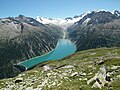
Image from the Höhenweg to the Schlegeis reservoir

Foundation board (... Höchstau 1783.55 m)

Schlegeissperrerererereperre, dam wall (unpowered area light)
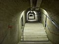
Inspection corridor inside the dam

Sighting eyepieces for the plumb line to measure inclination in the dam


Häusling power plant and Zillergründl reservoir

The rear part of the Zillergrund is called the Zillergründl. The reservoir of the Zillergründl reservoir expands here. The water flows through a 7.6 km long tunnel from the storage facility to the Häusling power plant and then through an 8.5 km long tunnel to the Stillup storage facility. The 64 meter high power house was built 40 meters deep into a rock slope, so that only around a third of the building is visible above the site.
| Brief data of the power plant: | |
|---|---|
| Power plant type | : Pumped storage power plant |
| Average Annual production | : 179.4 million kWh |
| Maximum power | : 360 MW |
| Machine sets | : 2 with vertical shaft |
| Turbines, pumps | : Francis turbines with radial pumps |
| Medium raw head | : 696 m |
| Expansion flow | : 65 m³ / s |
| Storage | : Zillergründl annual storage |
| Usable content | : 86.7 million m³ |
| Zillergründlsperre (height) | : 186 m |
| construction time | : 1974-1988 |
Lock Zillergründl
In 1980 the construction of the Zillergründl dam began. The barrage is designed as a double-curved arch weight wall. The water from the storage facility flows through an 8.6-kilometer-long headrace tunnel to the Häusling power plant and, after generating electricity, continues through a 7.8-kilometer tunnel to the Stillup storage facility .
The reservoir can be reached via an 18 km long toll road, which is closed to regular car traffic from the Gasthof Bärenbad (km 14), from here the dam can only be reached by public bus or bike (through 2 tunnels) (km 18).
The lock was the location for many series (such as Medicopter 117 - Every Life Counts ).

Zillergründl dam

Zillergründl dam

Foundation board


| Brief technical data of the barrage: | |
|---|---|
| Lock type | : Vault wall (double-curved arch weight wall) |
| Lock height | : 186 m |
| Crown length | : 506 m |
| Crown / base width | : 6.7 m / 42 m |
| Concrete volume | : 1.4 million m³ |
| Memory content | : 86.7 million m³ |
| Zillergründl storage facility | : Annual memory |
| construction time | : 1980-1987 |
Mayrhofen power plant and Stillup storage facility


The water already used in the Häusling and Roßhag power plants is fed into the Stillup storage facility on the Stillupbach . From here it reaches the Mayrhofen power plant, which is 470 m lower . A dam with a length of more than 480 m and a height of 28 m, as well as a central sealing core made of asphalt concrete, was built as a final structure. The tightness of the dam and the subsoil is monitored with an extensive measuring system.
| Brief data of the power plant: | |
|---|---|
| Power plant type | : Storage power plant |
| Average Annual production | : 671.2 million kWh |
| Maximum power | : 345 MW |
| Machine sets | : 6 with horizontal shaft |
| Turbines | : Double Pelton turbines |
| Medium raw head | : 470 m |
| Expansion flow | : 92 m³ / s |
| Storage | : Stillup weekly memory |
| Usable content | : 6.8 million m³ |
| Stilluppdamm (height) | : 28 m |
| construction time | : 1965-71, 1976-77 |
Lock stillup
The Stillup dam is a 28 m high and 480 m long earth dam with a sealing core made of asphalt concrete. The tightness of the dam is checked by numerous measuring points around the dam. The results are forwarded to the Mayrhofen headquarters.

View of the reservoir in southeast direction

Gunggl power plant
The water from the Gungglbach (near Mayrhofen-Rauth ) is fed to the Gunggl small hydropower plant via a buffer storage tank and a 200 m long tunnel. The electricity generated is used to meet the needs of the power plant group.
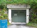
Gunggl power station entrance cavern
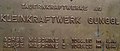
Gunggl power station blackboard


| Brief data of the power plant: | |
|---|---|
| Power plant type | : Run-of-river power plant |
| Average Annual production | : 6.6 million kWh |
| Maximum power | : 4,000 kW |
| Machine sets | : 2 with horizontal shaft |
| Turbines, pumps | : 1 Francis turbine, 1 volute casing pump |
| Medium raw head | : 210 m |
| construction time | : 1986-1990 |
Bösdornau power plant
The power plant in Bösdornau uses the diverted water of the Tuxbach and Zemmbach , which comes from the intermediate power plant Tuxbach via an 840 m long tunnel , and the water of the Stillupbach , which is led to the power plant via a 680 m long tunnel.
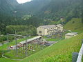
Bösdornau power plant outdoor facilities

Bösdornau power plant overview


| Brief data of the power plant: | |
|---|---|
| Power plant type | : Storage power plant |
| Average Annual production | : 68.9 million kWh |
| Maximum power | : 25 MW |
| Machine sets | : 5 with horizontal shaft |
| Turbines | : 2 Francis turbines, 2 twin free jet turbines, 1 free jet turbine |
| Medium raw head | : 200.5 m |
| Expansion flow | : 14.9 m³ / s |
| construction time | : 1928-30-39 |
Tuxbach power plant
For geological reasons, the Tuxbach had to be diverted 20 meters higher than the Zemmbach; the Tuxbach intermediate power station uses this gradient difference. It is located near Dornau above Bösdornau. There is also a feed line from the Zemmbach diversion below the Karlsteg inn.
| Brief data of the power plant: | |
|---|---|
| Power plant type | : Run-of-river power plant |
| Average Annual production | : 2.5 million kWh |
| Maximum power | : 400 kW |
| Machine sets | : 1 with horizontal shaft, |
| Turbines | : Twin Francis turbines |
| Medium raw head | : 20 m |
| Expansion flow | : 2.5 m³ / s |
| construction time | : 1928-1930 |
Gerlos power plant group
Funsingau power station and Durlaßboden reservoir

The upper stage of the Gerlos power plant with the Durlaßboden storage facility, which was planned during the Second World War, was realized between 1963 and 1967. The barrier of the Durlaßboden reservoir consists of an earth dam with a central sealing core. Water from the headwaters of the Salzach is fed into the reservoir. The power plant has since been expanded and has a peak output of 200 MW.
The headrace runs on the left side of the Gerlostal, is a total of 2.7 km long and consists of a pressure tunnel (2.9 m diameter) followed by a 175 m long penstock (2.4 m diameter) to the power plant. The machine house of the Funsingau power plant was built on the left bank of the Gerlosbach, approx. 2 km into the valley from Gerlos. The vertically installed machine set consists of a Francis turbine and a three-phase synchronous generator with an output of 25 MW.
The water used then flows further in the Gerlosbach to the Gmünd reservoir.
| Brief data of the power plant: | |
|---|---|
| Power plant type | : Storage power plant |
| Average Annual production | : 27.0 million kWh |
| Maximum power | : 25 MW |
| Machine sets | : 1 with vertical shaft |
| Turbines, pumps | : Francis turbine |
| Medium raw head | : 117.9 m |
| Expansion flow | : 26 m³ / s |
| Durlassboden storage facility | : Annual memory |
| Usable content | : 50.7 million m³ |
| Durlassbodendamm (height) | : 83 m |
| construction time | : 1963-1967 |
Lock Durlaßboden
The storage lake's target is 1,405 m; up to 50.7 million m³ of water can be stored. The barrage was built as a bulk dam with a central sealing core with a height of 83 m and a length of 450 m. To seal the subsurface, an injection screen was installed that extends up to 60 m deep.

Gerlos / Durlaßboden power plant group
Air side of the Durlaßboden dam

Water side of the Durlaßboden dam

Durlassboden reservoir against a mountain backdrop

Dam wall from above

View of the reservoir in south direction

View from Königsleiten to the snow-covered reservoir


Gerlosbach power plant and Gmünd reservoir
The gradient of the Gerlosbach is approx. 600 meters in the lower area. The water is dammed up in the Gmünd dam (directly above is the small Gmünd run-of-river power plant owned by TIWAG) and processed in the Gerlos power plant near Rohrberg 7 km below. The power plant was built during the Second World War.
| Brief data of the power plant: | |
|---|---|
| Power plant type | : Storage power plant |
| Average Annual production | : 309.3 million kWh |
| Maximum power | : 65.2 MW |
| Machine sets | : 4 with vertical shaft |
| Turbines, pumps | : Pelton turbines |
| Medium raw head | : 610.5 m |
| Expansion flow | : 13.5 m³ / s |
| Gmünd storage facility | : Weekly memory |
| Usable content | : 0.85 million m³ |
| Gmündsperre (height) | : 40 m |
| construction time | : 1943-1945, 1991-1993 |
2005-2007
Lock Gmünd
The barrage of the Gmünd reservoir is 40 m high. It is the oldest vaulted wall in Austria and was built from 1943 to 1945. The storage target is 1,191 m, with a capacity of 0.85 million m³. The headrace runs on the right side of the Gerlostal and is a total of 7.6 km long. The machine house of the Gerlos power plant is at the foot of the Rohrerberg in the Zillertal. The machine sets consist of 4 two-nozzle Pelton turbines with synchronous generators with a total output of 65 MW. Next to it is the second power house with a modern six-nozzle Pelton turbine and a total output of around 200 MW.

Gmünd storage barrier

Gerlos power plant construction site


See also
Web links
-
 Category: Hydraulic engineering in the Ziller catchment area with all coordinates
- Website for the Roßhag power plant
- Website for the Häusling power plant
- Website for the Mayrhofen power plant
- Website for the Funsingau power plant
- Website for the Tuxbach power plant
- Website for the Bösdornau power plant
- Website for the Gunggl power plant
- Website for the Gerlos power plant
- Construction film about the construction of the Zillergründl barrier on bauforum24 TV
- Exact tour description and topographic sketch #Schlegeis 131 on bergstieg.com
Individual evidence
- ↑ Beatrix Pinzer, Egon Pinzer: Zillertal - Gerlostal - Tuxertal , 2000, p. 233
- ↑ Krivdic, Wiesauer: chapel shrine , memorial chapel hl. Barbara, Schlegeiskapelle. In: Tyrolean art register . Retrieved June 15, 2018 .
- ↑ For the daring, Kleine Zeitung, print, June 26, 2016, p. 13.
- ↑ http://www.bergstieg.com/klettersteig/tirol/zillertaler-alpen/schlegeis-131-klettersteig # Schlegeis 131 Klettersteig, description, video (1:49), bergstieg.com, June 25, 2016, accessed 26. June 2016.
- ↑ http://www.zillertalfoto.at/2016/06/25/eroeffnung-schlegeis131-spektakulaerster-klettersteig-der-welt/ opening "Schlegeis131" - most spectacular via ferrata in the world. zillertalfoto.at, June 25, 2016, accessed June 26, 2016.
- ↑ Archived copy ( memento of the original from June 26, 2016 in the Internet Archive ) Info: The archive link was inserted automatically and has not yet been checked. Please check the original and archive link according to the instructions and then remove this notice. J. Riezinger, R. Flesch. Dynamic investigations at the Schlegeis vault barrier. Pp. 209-223. in: Seismic impacts on structures with different risk potential; European regulations. Volume of lectures on the three-country conference 1993. DGEB. Berlin 1994. ISBN 3930108046 . - With drawings of the longitudinal and cross-section of the dam and its surroundings.