
Zemmbach

The Zemmbach is an approximately 29 km long left tributary of the Ziller in the Austrian state of Tyrol . It drains the Zemmgrund , one of the high valleys in the Zillertal Alps , flows through the Zemmtal and flows into the Ziller in Mayrhofen in the Zillertal . Zemmtal is only called the lower reaches of the Zemmbach, if one means its whole valley, one speaks of Zemmbachtal.
River course
The Zemmbach arises from several glacial streams . The hydrographic source flow rises from the ice lake at the Zsigmondyspitze at 2674 m above sea level. A. , a glacier remnant Karsee created in recent years , and flows through the Schwarzensee below. A strong flow arises from the Gletschertor of Schwarzensteinkees northwest below the black stone . Then further outflows from the Hornkees and Waxeggkees follow from the Zillertal main ridge . The Zemmbach flows westwards here. At the Alpenrosenhütte , the Zemmbach is mostly diverted via a tunnel under the Great Greiner to the Schlegeis reservoir to the west ( ⊙ ).
Due to further glacier inflows below the Schönbichler Horn , the amount of water increases again, and there at the Grawandhütte the brook turns a knee to the north into the almost 4 km long lower Zemmgrund. This is already wooded Almenland, with Schwemmalm and Klausenalm .
At Breitlahner (Gasthof, Jagdhaus Karlshütte ) the Zamser Bach flows from the left and the Zemmbach enters the Zemmtal north-east. Here the Zemmbach flows south of the Tux main ridge . As a result, the Ingentkarbach flow from the right at Roßhag and the Gungglbach at Rauth , as well as the Floitenbach at Dornauberg-Ginzling , the last two forming larger side valleys (locally called reasons ). At Finkenberg , the Zemmbach finally takes up the 18 km long Tuxbach from the left, which rises southwest of the Hintertux Glacier below the Pfannköpfl and drains the subsequent Tuxertal north of the Tux main ridge.
The last tributary before the mouth in Mayrhofen is the Stilluppbach again from the south. As the Mayrhofen power plant drains the Stillupp reservoir shortly before its confluence , which also receives a lot of water from the neighboring valleys, contrary to the original conditions at the confluence, it carries far more water than the Zemmbach.
The entire length of the stream forms the municipal boundary of Finkenberg on the left and Mayrhofen on the right bank, so that all valleys belong to both municipalities.

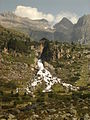
Zemmbach above the Berliner Hut towards Schwarzenstein
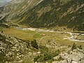
Zemmbach below the Berliner Hut
Weir at the Alpenrosenhütte
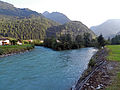
Inflow of the Stilluppbach (left) into the Zemmbach
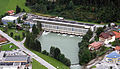
Mayrhofen power plant , 200 m above the Zemmbach inlet


fauna
Brook trout , rainbow trout and brown trout live in the Zemmbach .
Web links
Individual evidence
- ↑ a b Zillertal Alps Nature Park ( Memento of the original from December 28, 2013 in the Internet Archive ) Info: The archive link has been inserted automatically and has not yet been checked. Please check the original and archive link according to the instructions and then remove this notice. . Folder, Seen , p. 6 (pdf, zillertal.at, accessed on June 12, 2014).
- ↑ a b c TIRIS online, topic water: rivers / lakes , layers for water bodies and catchment areas.
- ↑ Land Tirol: Hydrographic characteristics
- ^ Ministry for an Austria worth living in (ed.): Hydrographisches Jahrbuch von Österreich 2013. 121st volume. Vienna 2015, PDF (9.0 MB) on bmlrt.gv.at (2013 yearbook) - data and evaluations, p. OG 347 (PDF; 22.7 MB)
- ↑ a b The name Eissee is not yet on the Austrian map in 2015; Because this lake is young, the Mayrhofen – Finkenberg municipal boundary no longer runs through the lake, as is the case at the Schwarzensee: The Roßkar is entirely Mayrhofen.