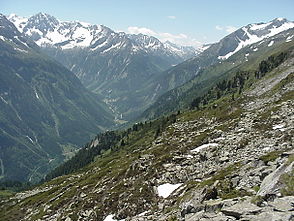
Zemmtal
| Zemmtal (Dornaubergtal) | ||
|---|---|---|
|
Zemmtal with Breitlahner |
||
| location | Tyrol | |
| Waters | Zemmbach | |
| Mountains | Zillertal Alps | |
| Geographical location | 47 ° 5 ' N , 11 ° 46' E | |
|
|
||
| height | 650 to 1250 m above sea level A. | |
| length | 13 km | |
The Zemmtal , also called Dornaubergtal , is a side valley of the Zillertal in the Zillertal Alps ( Tyrol , Austria ).
The Zemmtal arises at the meeting of Zamser Grund and Zemmgrund near Breitlahner above Dornauberg-Ginzling and extends into the valley basin of Mayrhofen . The Zemmbach flows through the entire length of the Zemmtal, which flows into the Ziller in Mayrhofen . As is customary in the area, the name Zemmtal - or Dornaubergtal - only refers to the valley of the lower reaches of the Zemmbach. If you mean the entire valley including Zemmgrund (or also Zamsergrund), one speaks of Zemmbachtal .
The right side of the valley belongs to Mayrhofen , the left to Finkenberg . To the north is the Tux main ridge , the southern side valleys are the Gunggl , the Floite , at the confluence of which the village of Ginzling is located, and the Ingentkar .
Web links
Individual evidence
- ↑ Austrian map 1: 50,000 ( online )
- ↑ Alpine Club Card Zillertal Alps - West. German Alpine Club, 7th edition 2006

