
Floitengrund
| Floitengrund | ||
|---|---|---|
 ~ 1300 m in the Floitental towards the SE at the head of the valley |
||
| location | Tyrol , Austria | |
| Waters | Floitenbach | |
| Mountains | Zillertal Alps | |
| Geographical location | 47 ° 3 '49 " N , 11 ° 51' 30" E | |
|
||
| height | 1000 to 2000 m above sea level A. | |
| length | 9 km | |

The Floitengrund , also called the Floite or the Floitental , is a side valley of the Zemmtal in the Zillertal Alps ( Tyrol , Austria ).
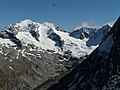
The dominant mountains of the Floitengrund are the Große Löffler (3379 m), the Westliche Floitenspitze (3195 m) and the Große Mörchner (3285 m) at the end of the valley, as well as the Floitenturm (2805 m), the Gigalitz (3002 m) at the Northeast flank and the Zsigmondyspitze (3089 m) on the southwest flank of the valley. The hiking trail with the Alpine Club number 521 runs through the entire Floitengrund. At the end of the valley at an altitude of around 1834 m (bridge), the trail meets the Berliner Höhenweg . This leads from the Mörchenscharte (2872 m) from the Zemmgrund through the Floitengrund to the Lapenscharte (2701 m) in the Stilluppgrund and opens up the Greizer Hut , which is located at 2227 m in the upper Floitengrund.
The Ibex March has been held annually since 1969 . This runs from Ginzling through the Floitengrund, over the Mörchenscharte, through the Zemmgrund to Gasthof Breitlahner. In bad weather, you can only walk from Ginzling through the Floitengrund to the Greizer hut and back.
Floitenbach
The Floitenbach, which drains the Floitengrund, rises from the Floitenkees at around 2150 m and flows into the Zemmbach at Ginzling ( 969 m ) . The stream is 10.7 km long and drains a catchment area of 38.8 km². The ecological condition of the Floitenbach is very good to good.

Böckachalm in Floitengrund
Floitenkees with a large spoonbill

Head of the valley with Floitenspitzen

Floitengrund from the path to the Mörchnerscharte
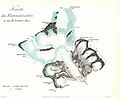
Map of the Floitenkees by Carl Sonklar (south above, heights in Austrian feet )


Web links
Individual evidence
- ↑ ÖK 50, published by the Federal Office for Metrology and Surveying
- ↑ Ortverzeichnis Tirol 2001, p. 175 ( Memento of the original from April 26, 2014 in the Internet Archive ) Info: The archive link was inserted automatically and has not yet been checked. Please check the original and archive link according to the instructions and then remove this notice.
- ↑ Alpine Club Card 35/2: Zillertal Alps - Center. 7th edition 2008.
- ↑ Das Floitental ( page no longer available , search in web archives ) Info: The link was automatically marked as defective. Please check the link according to the instructions and then remove this notice. on the website of the Zillertal Alps Nature Park
- ↑ Current information on the Ibex March ( memento of the original from September 2, 2011 in the Internet Archive ) Info: The archive link was inserted automatically and has not yet been checked. Please check the original and archive link according to the instructions and then remove this notice. on ginzling-dornauberg.at
- ↑ TIRIS - Tyrolean regional planning and information system
- ↑ Map: National water management plan, ecological status - Tyrol ( page no longer available , search in web archives ) Info: The link was automatically marked as defective. Please check the link according to the instructions and then remove this notice. (PDF; 3.3 MB)