Western Floitenspitze
| Western Floitenspitze | ||
|---|---|---|
|
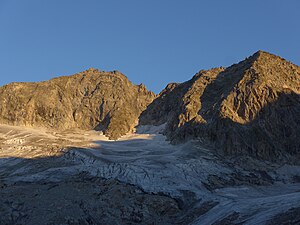
Western (left) and Eastern Floitenspitze from the southeast |
||
| height | 3195 m above sea level A. | |
| location | Tyrol , Austria and South Tyrol , Italy | |
| Mountains | Zillertal Alps | |
| Dominance | 1.1 km → Felsköpfl northeast of the Schwarzenstein | |
| Notch height | 168 m ↓ Floitenjoch | |
| Coordinates | 47 ° 1 '13 " N , 11 ° 53' 43" E | |
|
|
||
| First ascent | August 13, 1876 by Moritz von Déchy with Stephan Kirchler | |
| Normal way | From the west over the west flank and southwest ridge ( I ) | |
The Western Floitenspitze ( Italian Cima di Flòite Ovest ) is 3195 m above sea level. A. high summit in the Zillertal main ridge and lies on the border between the Austrian state of Tyrol and the Italian province of South Tyrol . It is the dominant peak in the valley head of the inner Floitengrund . It is connected to the Eastern Floitenspitze ( 3154 m ) about 500 meters away via a wild, ragged ridge.
Location and surroundings
The Floitenspitzen are located in the Zillertal main ridge between the Schwarzenstein ( 3369 m ) in the west and the Großer Löffler ( 3379 m ) in the east. The western Floitenspitze is separated from the Felsköpfl, the northeastern pre-summit of the Schwarzenstein, by the Trippachsattel ( 3,013 m ), where the Schwarzensteinhütte is located. In the south-west ridge, which descends towards the Trippachsattel, there is still the Trippachkopf ( 3111 m ), a hardly independent pre-summit.
The Eastern Floitenspitze separates the Floitenjoch ( 3027 m ) from the Trippachspitze ( 3271 m ), a pre-peak in the southern ridge of the Großer Löffler. The deepest notch in Connection Ridge between Floitenspitzen measures 3095 m . In addition to this connecting ridge running in a north-easterly direction and the south-west ridge, which also forms the main ridge, the western Floitenspitze sends another distinctive ridge to the northwest.
To the southeast of the Floitenspitzen is Trippachkees , which has meanwhile disintegrated into several parts . The glaciation is much stronger on the northwest side, where the Floitenkees is located.
Alpinism
The first ascent of the Western Floitenspitze was made by Moritz von Déchy from Budapest with guide Stephan Kirchler from Luttach on August 13, 1876. They started at 4 am in Luttach, passed the Trippachjoch at 10 am and reached the summit shortly before 11 am.
Today's normal route leads from the Schwarzensteinhütte over the glaciated Trippachsattel and then initially to the east in the direction of the Trippachkopf. A little north of the Trippachkopf you get to the southwest ridge of the Westliche Floitenspitze. Over this block ridge, sometimes dodging into the northwest flank, you soon reach the summit with a cross, which is already visible from afar, with easy climbing. It takes about an hour from the hut.
The north-west ridge and north face offer challenging climbing routes. The transition to the eastern Floitenspitze is also demanding ( IV ) and very exposed.
Literature and map
- Heinrich and Walter Klier : Alpine Club Guide Zillertal Alps , Bergverlag Rother , Munich 1996, ISBN 3-7633-1269-2
- Topographic hiking map, Ahrntal / Rieserferner Group , sheet 035, 1: 25,000, Casa Editrice Tabacco, ISBN 88-8315-035-X
Web links
Individual evidence
- ↑ Clem Clements, Jonathan de Ferranti, Eberhard Jurgalski , Mark Trengove: The 3000 m SUMMITS of AUSTRIA - 242 peaks with at least 150 m of prominence , October 2011, p. 13.
- ↑ Federal Office for Metrology and Surveying Austria: Western Floitenspitze on the Austrian Map online (Austrian map 1: 50,000) .
- ^ A b c Heinrich and Walter Klier: Alpenvereinsführer Zillertaler Alpen , Bergverlag Rother, Munich 1996, ISBN 3-7633-1269-2 , pp. 255–260
- ^ German and Austrian Alpine Association (ed.): Communications from the German and Austrian Alpine Association. Volume 2, Frankfurt a. M. 1876, p. 273 ( online )

