
Zamser reason
| Zamser reason | ||
|---|---|---|
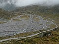
 View of the Pfitscher Joch from the Zamser Grund |
||
| location |
|
|
| Waters | Zamser Bach | |
| Mountains | Zillertal Alps | |
| Geographical location | 47 ° 1 '22 " N , 11 ° 41' 6" E | |
|
||
| height | 2500 to 1250 m above sea level A. | |
| length | approx. 9 km | |

The Zamser Grund is the original valley (Grund) of the Zamser Bach south-west of Mayrhofen in the Zillertal in the Zillertal Alps in Tyrol .
The Zamser Grund extends from the end of the Zemmgrund on the Zemmbach -Oberlauf near Breitlahner above Dornauberg-Ginzling in a south-westerly direction to the Pfitscher Joch ( 2246 m above sea level ). The Zamser Bach flowing through it rises at the foot of the Stampflkees below the Hohe Wand ( 3289 m above sea level ). The valley belongs to the municipality of Finkenberg .
In the west and north the valley is bordered by the Tuxer Kamm with the Olperer ( 3476 m above sea level ) as the highest peak. The Schlegeisgrund branches off in a south-easterly direction to the main ridge of the Zillertal , and today it is largely occupied by the Schlegeis reservoir. Below the reservoir, the valley continues to the Zamserbach confluence with the Zemmbach.
High alpine crossings exist over the Pfitscher Joch into the South Tyrolean Pfitscher valley and over the Alpeiner Scharte ( 2959 m above sea level ) into the Valser valley .

Schlegeis reservoir with Zamser Grund

Zamser Grund with Hochferner
Zamser Bach with Lavitzalm


