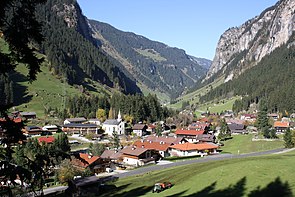
Dornauberg-Ginzling
|
Dornauberg ( Rotte ) locality administrative district |
||
|---|---|---|
|
|
||
| Basic data | ||
| Pole. District , state | Schwaz (SZ), Tyrol | |
| Pole. local community | Finkenberg | |
| Coordinates | 47 ° 5 '59 " N , 11 ° 48' 27" E | |
| height | 985 m above sea level A. | |
| Residents of the village | 200 (January 1, 2020) | |
| Post Code | 6295 | |
| Mayor | Rudolf Klausner | |
| address | Nature Park House 239 6295 Ginzling |
|
| Official website | ||
| Statistical identification | ||
| Locality code | 16999 | |
| Counting district / district | Finkenberg (70908 000) | |
 Dornauberg-Ginzling in winter |
||
| Source: STAT : index of places ; BEV : GEONAM ; TIRIS | ||
| Ginzling ( village ) | |
|---|---|
| Basic data | |
| Pole. District , state | Schwaz (SZ), Tyrol |
| Pole. local community | Mayrhofen |
| Locality | Mayrhofen |
| Coordinates | 47 ° 5 ′ 57 " N , 11 ° 48 ′ 31" E |
| Residents of the stat. An H. | 137 (1991) |
| Post Code | 6295 |
| Source: STAT : index of places ; BEV : GEONAM ; TIRIS | |
Dornauberg-Ginzling , often just called Ginzling , is a place in the Schwaz district in Tyrol , part of which belongs to the municipality of Mayrhofen and partly to the municipality of Finkenberg . Ginzling is part of the Bergsteigerdörfer -Initiative of the PES .
geography
Dornauberg-Ginzling is 985 m above sea level. A. in the Zemmtal at the confluence of the Floitengrund . The part west of the Zemmbach belongs as a fraction of Dornauberg to the municipality of Finkenberg, the eastern part is part of the municipality of Mayrhofen as the village of Ginzling. The Zemmbach , which drains into the Ziller , not only forms the parish, but also the diocesan border (the west belongs to the diocese of Innsbruck , the east to the archdiocese of Salzburg ).
The place is the end point of the Zillertalstrasse , which merges here into the private, toll road Schlegeis-Alpenstrasse. The Pfitscher Joch can be reached from Ginzling ( on foot or by bike from the Schlegeis reservoir ). Ginzling has its own local board (Rudolf Klausner) and its own zip code (6295).
history
Traces of settlement in the Zemmtal and field names such as Zams, Zemm or Floite go back to pre-Roman times. The first settlers were probably herdsmen who came from the south with their cattle over the Pfitscher Joch. Schwaighöfe were laid out in the 13th and 14th centuries . These farms, subordinate to the landlord, were permanently settled and mainly operated cattle and dairy farming. One of these Schwaighöfe is mentioned in 1450 as Dornauberg , another around 1600 as Günzling . From the 17th century, during the Little Ice Age , the Schwaighöfe were abandoned and only managed as alpine pastures and branches in summer. Ginzling later became a permanent settlement again. In addition to livestock farming, the mining of minerals such as garnet , a princely hunting ground in the Floitengrund and the Gunggl and the modest trade on the mule track over the Pfitscher Joch offered other opportunities to earn a living .
In 1833 a church, a school and a cemetery were built in Dornauberg. In 1838 Dornauberg was made an expositur and received its own curate . Due to the population growth, it was decided in 1850 to build a new church, which was supported in particular by the dean of Zell am Ziller , Ignaz Huber. On October 3, 1854, the Archbishop of Salzburg, Maximilian Joseph von Tarnóczy , consecrated the new Church of the Assumption of Mary .
Towards the end of the 19th century, Ginzling became a center of mountaineering tourism. More mountain guides were stationed here than in all the surrounding villages combined and the Berliner Hut in particular became a much-visited destination and starting point for hikes and climbing tours. In 1927, the connection to Dornauberg-Ginzling began to be developed as a road, and from 1930 there was regular mail traffic between Mayrhofen and Ginzling. In the course of the power plant construction, the road was expanded for heavy traffic from 1964 to 1966 and the Harpfnerwand tunnel was built.
Dornauberg-Ginzling has had its own local statute and local council since 1971.
In July 2008, Ginzling was the founding site and one of the first 17 members of the PES initiative Bergsteigerdörfer .
Personalities
- Hannes Obererlacher (* 1962), Austrian biathlete
- Willi Kröll (* 1949), former member of the band (Zillertaler) Schürzenjäger
- Richard Kröll (* 1968 in Schwaz, † 1996 in Stumm), Austrian ski racer
literature
- Gudrun Steger: Alpine history in a nutshell: Ginzling in the Zillertal. Austrian Alpine Club, Innsbruck 2010 ( PDF; 2.4 MB )
- Oesterreichischer Alpenverein (Ed.): Ginzling in the Zillertal: In the beginning there was mountaineering. Innsbruck 2012 ( PDF; 2.1 MB ) ( online )
Web links
- Website of the local authority
- Ginzling. In: Bergsteigerdörfer. Oesterreichischer Alpenverein, accessed on July 17, 2014 .
Individual evidence
- ^ Finkenberg community: Ginzling-Dornauberg road
- ↑ Ideas - Deeds - Facts, No. 1: Start conference mountaineering villages in the mountaineering village of Ginzling, from 10-11. July 2008 , Austrian Alpine Association as part of the project “Specific Alpine Convention: Via Alpina and Mountaineering Villages”, Spatial Planning-Nature Conservation Department, Innsbruck 2008, p. 4. PDF download ( Memento of the original from November 8, 2018 in the Internet Archive ) Info: Der Archive link was inserted automatically and has not yet been checked. Please check the original and archive link according to the instructions and then remove this notice. , accessed November 7, 2018.

