
Olperer
| Olperer | ||
|---|---|---|
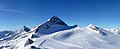
 Olperer (left) and Fußstein (right) from the west |
||
| height | 3476 m above sea level A. | |
| location | Tyrol , Austria | |
| Mountains | Zillertal Alps | |
| Dominance | 11.4 km → Hochfeiler | |
| Notch height | 1230 m ↓ Pfitscher Joch | |
| Coordinates | 47 ° 3 '11 " N , 11 ° 39' 32" E | |
|
||
| rock | Granite , gneiss | |
| First ascent | September 10, 1867 by Paul Grohmann , Georg Samer and Jakob Huber | |
| Normal way | Southeast Ridge ( II ) | |

The Olperer is a 3476 m above sea level. A. high mountain in the Zillertal Alps in the Austrian state of Tyrol . It is the main peak of the Tux ridge .
Location and surroundings
The Olperer has a striking appearance with its pyramid-shaped summit structure . Because of this, and because of its geographical dominance over its neighboring peaks, it is a popular panoramic mountain. It is about four kilometers as the crow flies north-west of the Schlegeisspeicher dam and seven kilometers south of Hintertux. Neighboring mountains in the north, separated by the Wildlahnerscharte ( 3220 m above sea level ) are the Großer Kaserer with 3263 m above sea level. A. Height, in the southeast in the ridge of 3380 m above sea level. A. high Fußstein and in the northeast, separated by the Großes Riepenkees glacier, are the frozen wall peaks at 3270 m above sea level. A. Height in the south summit.


Bases and routes
The first ascent over the southeast ridge took place on September 10, 1867 by Paul Grohmann , Georg Samer and Gainer Jackl. The Hintertux Glacier ski area is located on its northern flank on the Tuxer Ferner glacier (also known as Frozen-Wand-Kees ). The path of Paul Grohmann and his companions led from the southeast over the Riepenkar and Riepengrat . Their base was in the Zamser Grund .
The Olpererhütte , at 2388 m above sea level , has served as a base since 1881 . A. Located at altitude. Grohmann's route is still the normal route today . According to literature, the walking time from the hut is around four hours. The path runs along the southeast ridge. After a relatively simple block climb, you reach the snow gully field . The directly adjoining key point was defused by wire ropes, but at least self-belaying is pleasant here, as it goes very steeply upwards. This is followed by a not very difficult (UIAA I-II), but very exposed, uninsured ridge passage. Securing points for your own rope belay are available. The further way to the nearby summit is a little easier again, but remains very exposed. Another ascent leads from the Wildlahnerscharte over the north ridge, which is sometimes icy even in high summer ( easy to difficult climbing UIAA II to III ). The Wildlahnerscharte can be reached from the Geraer Hütte ( 2324 m above sea level ), first north-east over the Olpererferner south past the Wildlahnergrat (some crevasses ) (four hours to the summit); from the Tuxer Fernerhaus ( 2605 m above sea level ) through the ski area; or from the Olpererhütte through the Großer Riepenkees and then also through the ski area.
Literature and map
- H. Klier and W. Klier : Alpenvereinsführer Zillertal Alps , Munich 1996, ISBN 3-7633-1269-2
- Alpine Club Map 1: 25,000, sheet 35/1, Zillertal Alps West
photos
Overlooking the Olperer of the Frozen wall tips from

Olperer from the northwest, on the right the foot stone

Olperer and Fußstein, view from the Wildlahnertal near Schmirn


Web links
- Ginzling Mountain Rescue: Information about the Zillertal Alps. (No longer available online.) Archived from the original on March 27, 2012 ; accessed on April 12, 2020 .
- Olperer Südostgrat, Nordgrat and Nordostwand: Tour description with pictures alpin-welt.at
- 360 ° panoramic image of the Olperer
Individual evidence
- ↑ Eberhard Jurgalski : Complete table of summits in the Alps separated by 590 meters of re-ascent , December 12, 2008.
- ↑ Federal Office for Metrology and Surveying Austria: Olperer on the Austrian Map online (Austrian map 1: 50,000) .
- ^ Journal of the German and Austrian Alpine Association , Volume II, 1870/71, Munich 1871, p. 132 f.
- ^ Carl Diener in Eduard Richter : The Development of the Eastern Alps , III. Volume, Berlin 1894, p. 89.