
Dolomites
| Dolomites | |
|---|---|
 Location of the Dolomites within the Eastern Alps according to AVE |
|
| Highest peak | Marmolata ( 3343 m slm ) |
| location | Provinces of Belluno , Bozen – South Tyrol and Trento |
| part of | Southern Limestone Alps |
| Classification according to | AVE 52 |
| Coordinates | 46 ° 25 ′ N , 11 ° 50 ′ E |

The Dolomites , Italian Dolomiti , Ladin Dolomites , are a mountain group of the southern Limestone Alps , but are also included in the Southern Alps . They are distributed over the regions of Veneto and Trentino-South Tyrol in Italy or - in roughly equal proportions - in the provinces of Belluno , Bolzano - South Tyrol and Trento . Parts of the Dolomites have been part of the Dolomites UNESCO World Heritage Site since 2009 .
The highest mountain in the Dolomites is the Marmolada at 3343 meters (see also the list of three thousand meter peaks in the Dolomites ). Other well-known peaks or massifs are the Civetta , Monte Pelmo , Antelao , Drei Zinnen , Sella , Rosengarten , Schlern , Geisler and Langkofel .
Demarcation
The delimitation of the Dolomites is handled differently. According to conventional understanding, they are in the north through the Pustertal , in the east through the Sextental , the Kreuzbergpass and Piave , in the south again through the Piave, the line Feltre- Genebe / Enego and the Valsugana , and in the west through the valleys of Etsch and Eisack limited.
According to the Alpine Club division of the Eastern Alps , the western mountain groups of the Fiemme Valley Alps and the Vicentine Alps facing the Adige are no longer part of the actual Dolomites. But this group also includes mountains up to the southern edge of the Alps, which otherwise belong to either the Vicentines or the Belluno Prealps .
In addition, the mountains and valleys east of the Piave, such as the Friulian Dolomites , Val Montanaia , Cima dei Preti , Monte Duranno or Col Nudo , are counted among the Dolomites. Partly also the limestone mountains west of the Adige, which are called Brenta (Dolomiti di Brenta, Brentaner Dolomites) . In the following, the term is limited to the mountains between the Adige and the Piave.
Neither the nearby Lienz Dolomites , the Arosa Dolomites nor the Lower Engadine Dolomites belong to the Dolomites described here: They are only named because of their morphological similarity, but they belong to different ceiling systems.
structure
The Dolomites are divided into various groups, some of which can be subdivided into further subgroups (indented):
pictures

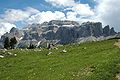
Ciampestrin and Marmolada

The Geisler peaks

The Langkofel
The Sella Group

Rose garden group
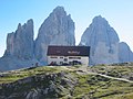
The three peaks


Valleys

The Dolomites are bordered in the west by the Eisack Valley and south of Bozen by the Adige Valley. To the north they border on the Puster Valley, with the Rienz , which flows into the Eisack Valley near Brixen.
West of Bruneck in the Puster Valley is the entrance to the Gadertal (Val Badia), which leads south to the Sella Group. Via the Gardena Pass in the north of the Sella it is connected to the Val Gardena, which leads west to the Eisack valley. The Alpe di Siusi and the Schlern-Rosengarten nature park are located south of the Val Gardena .
Val Gardena and Val Badia together with Fodom and Fassa Valley as well as the municipality of Cortina d'Ampezzo form the area in which the Ladin language is still spoken. From Pordoijoch south of the Sella Fodom the east, the Val di Fassa leads, however, to the southwest. While the Fassa Valley is formed by the upper reaches of the Avisio , the lower reaches of the Val di Fiemme flows through the Val di Fiemme to the Adige Valley near Trento (it. Trento ), the name difference between the two valleys has historical reasons.
Other side valleys of the Eisack Valley are the Villnößtal in the north (between Pustertal and Gröden), which is connected to the Gadertal via the Würzjoch , and the Tierser Valley south of the Schlern massif, which leads to the Rosengarten and is connected to the Eggental via the Niger Pass . The Eggental begins at the Karer Pass south of the Rosengarten and also leads west to the Eisack Valley near Bozen. The east side of the Karer Pass leads into the Fassa Valley.
Other side valleys of the Pustertal are the Höhlensteintal and the Sextental . The Höhlensteintal separates the Braies Dolomites from the Sesto Dolomites in the east and leads up to Monte Cristallo . The Sextental is part of the eastern border of the Dolomites in general. It is connected to eastern Cadore and the Piave valley via the Kreuzbergpass .
South of the Cristallo is Cortina d'Ampezzo in the Valle del Boite , the western part of the Cadore, which also leads to the Piave.
The Valle Agordina is the lower reaches of the Cordevole , which, after its source at the Pordoi Pass, first flows through the western Fodom and flows southwest of Belluno into the Piave. The Valle Agordina is dominated by the Marmolada and Pala to the west and the Civetta to the east. To the east of the Civetta lies the Val di Zoldo , which already meets the Piave valley ( Valbelluna ) north of Belluno .

geomorphology


.jpg)
The abrupt change between gently undulating alpine pastures and the steep limestone and dolomite reefs that sit on them is characteristic of the Dolomites . Some of the reefs rise up to a height of around 3000 to 3200 m. What is interesting here is a clear terracing at around 2300 m (Schlern) and 2800 m (Sella massif). The Fanes plateau or the Gardenaccia-Crespaina plateau are also among these terraces. In contrast, there are the heavily rugged massifs such as the Langkofel, Sesto Dolomites and Rosengarten. The causes of these different manifestations include: the highly structured layer structure (clearly visible on the west flank of the Rosengarten), the alternating uplift and lowering of entire rock blocks with different flooding phases (visible e.g. on the Sella group) as well as the breaking up of the closed formations by magma ducts .
The mountains consist to a large extent of sedimentary rock , which clearly shows typical layers. In between there are layers of petrified coral reefs that grew in the Tethys of the Triassic . This rock is called dolomite , a distinction is made between different lithostratigraphic units such as Schlern dolomite and overlying main dolomite . Volcanic traces ( igneous rock ) can also be discovered. In the Latemar, for example, there are deep cuts in the main ridge - only a few meters wide, but up to 200 meters deep - at the bottom of which dark, cushion-like, rounded lava rock emerges. The small Padon ridge between Sella and Marmolada consists entirely of lava rock. Towards the Adige Valley there are whole porphyry plateaus ( porphyry plateau of Bozen , the Fleimstal Alps and the southern Sarntal Alps ).
Since the cooled lava is much softer than the surrounding limestone, these areas are more weathered and less high. It often forms the bedrock of the vast alpine pastures in the Dolomites and is partly responsible for the wild fissures of some massifs (such as the Latemar).
In the past, some mountain groups still carried noteworthy glaciers , the only larger glacier still in existence is the Marmolata glacier.
The name of the Dolomites as well as the dolomite rock is derived from the French geologist Déodat de Dolomieu (1750–1801). Before he described the dolomite rock, the name Monti pallidi ('pale mountains') was common. The actual rock described by Dolomieu or the mineral dolomite contained therein , however, only makes up a small part of the Dolomites. It is yellowish in color due to its high magnesium content and can be found among others. in the area of the Fanes, the three peaks and the rose garden, recognizable by the yellowing of the vertical wall breaks (inclined rock sections are colored gray due to weathering). The remaining areas consist mainly of whitish-gray limestone sediments with a small proportion of dolomite, as can also be found in the northern limestone Alps . Because of the similar rock structures, the name has been transferred to the entire Dolomites as well as to the corresponding limestone sedimentary rock, the differences are then differentiated with other names (see above).
Stratigraphic sequence
The lithostratigraphic sequence of the Dolomites (incomplete):
- Bolzano volcanic complex : These Permian porphyries form the basement in the entire Dolomites . The complex is 1000 to 1300 meters thick. The fluctuations form a paleo-relief .
- Val Gardena sandstone formation : These sandstones are hardly weather-resistant and therefore form flat alpine pastures.
- Bellerophon formation : around 200 m thick
- in the triad: Werfener layers (between 100 and 350 m) divided into Seiser and Campiller layers
- Mendeldolomite
- Buchensteiner layers: few, up to around 100 m high
- Schlerndolomit : over 1000 m thick
- Raibler layers : (form the distinctive middle class of the Sella group)
- Dachstein / main dolomite
population
The Dolomites form the distribution area of the Ladins (see Ladin language ) and are also crossed by the language border between German and Italian . The Ladins mainly live in the four valleys of the Sella, Gröden, Fassa, Buchenstein and Gadertal (Badia). In these valleys the localities are often named in all three languages. The Friulians mainly inhabit the Val Vajont, Valcellina, Alta Valle del Tagliamento, Val Colvera and Alta Val Tramontina.
story

The Dolomites emerged as a Ladin language area from the migration of peoples, but were partially Germanized by Bavarian settlers with the emergence of Tyrol and the incorporation of Trentino into the Holy Roman Empire from the Middle Ages onwards, with Italian advancing from the south .
In the 18th century, the mountains were still called "pale mountains" or "monti pallidi". The name 'Dolomites' spread after the predominant rock was given the name dolomite , in honor of the French geologist Déodat de Dolomieu (1750–1801), who was the first to analyze its composition. (See also: Dolomite (rock) #History )
The border between Germany or Austria and Italy ran through the Dolomites throughout the high and late Middle Ages and up to the Napoleonic period . The Austrian-Italian border also ran here between 1866 and 1918. It essentially followed today's provincial border between Trentino-South Tyrol and Veneto, but the Buchenstein (the uppermost part of the Cordevole Valley) and Cortina were Austrian.
During the Mountain War of 1915–1918 , when Italy fought on the side of the Entente in World War I , the border was a mountain front. In the course of their offensive, however, the Italians only succeeded in occupying Cortina and parts of the Buchenstein, so that the front, after stabilizing, for example, from Passo San Pellegrino via Marmolada, Col di Lana , Lagazuoi , the Tofanen , Hohe Gaisl , Schluderbach , Monte Piana , Drei Zinnen and Paternkofel to Kreuzbergsattel ran. In many places, traces of war can still be seen, especially the summit of Col di Lana, which was blown up and collapsed.
The Gherdëina Museum in Ortisei houses a rich collection on the history of the Val Gardena and the Dolomites (including fossils and minerals).
economy
The biggest economic factor in the region is year-round tourism . Popular locations are Cortina d'Ampezzo , Rocca Pietore , Ortisei , Arabba , Wolkenstein , Corvara in Badia , San Martino di Castrozza in Primiero and Canazei in Val di Fassa.
The alpine farming (mainly cattle breeding ), which is carried out by the local population, has become an important part of tourism with its traditions, although its original function as a pure food supplier has now lost importance. In some places in the Dolomites, mainly in Val Gardena , handicrafts , especially wood carving, have a proven tradition since the 16th century and are still of great economic importance.
Skiing

Twelve ski areas in the Dolomites came together in 1974 to form the Dolomiti Superski network . It includes 460 lifts and over 1200 kilometers of slopes that can be used with a single ski pass. The heart of the lift network are the Sellaronda and the adjacent Gardena Ronda .
Mountain sports
The Dolomites can be hiked through on ten different Dolomite high-altitude trails .
Individual evidence
- ^ Ernst Höhne: Knaurs Lexicon for Mountain Friends / The Alps between Chiemsee and the Dolomites . Droemer Knaur, Munich 1986, ISBN 3-426-26222-3 , pp. 66 f .
- ↑ Mapping report Dolomites , Rodrigo Garcia, 2011 . Grin Publishing House
Web links
- Overview map: geographical extent of the Dolomites
- Entry on the website of the UNESCO World Heritage Center ( English and French ).
- Sigm (and) Schneider: The South Tyrolean Dolomites. With twelve original photographic (aphic) recordings by Karl Wipplinger. In: Österreichs Illustrierte Zeitung , year 1903, issue 27/1904, April 3, 1904 (XIII. Year), p. 570 f. (Online at ANNO ). .
