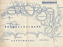
Geisler group
| Geisler group | |
|---|---|
|
Location of the Geisler Group in the Dolomites |
|
|
Geisler from the south |
|
| Highest peak | Sass Rigais and Furchetta ( 3025 m slm ) |
| location | South Tyrol , Italy |
| part of | Dolomites |
| Coordinates | 46 ° 37 ' N , 11 ° 46' E |

The Geisler Group ( Italian Gruppo delle Odle ) is a mountain group of the Dolomites that forms the ridge between Villnöß and Val Gardena in South Tyrol ( Italy ). The Geisler Group is largely located in the Puez-Geisler Nature Park . The main peak is the Sass Rigais ( 3025 m ) in the eastern part of the mountains.
Location and surroundings
The Geisler group is bordered in the south by Val Gardena, in the north by Villnöß and in the west by the Eisack valley . In the east, the Roa-Scharte (Ladin Furcela dla Roa ) represents the transition to the Puez group, from which it is further separated by the Cislesbach and with which it is often combined as the Puez-Geisler group . In the northeast, the Kreuzjoch (Ladin Furcela de Munt de Furćia ), which connects Villnöß with the Campilltal , separates the Geisler group from the Peitlerkofel group .
structure
The Geisler Group can be divided internally into two parts: the high and distinctive Geisler (also Geisler peaks or Villnößer Geisler) east of the Pana-Scharte and the moderately pronounced foothills to the west towards the Eisack valley.
Geisler
Within the Geisler (or Geisler peaks), in the west, a mountain group, called Odles , i.e. needles in Ladin , can be easily separated from the main group around the Sass Rigais by the Mesdì-Scharte (Mittagsscharte) . The Odles begin in the west at the Pana-Scharte (2447 m) and consist of the Lower and the Upper Fermeda, the Small (2814 m) and the Big Fermeda (2873 m), the Funes Tower (2834 m) a little to the north, the Odla de Cisles (2780 m) further south, the Gran Odla (Geislerspitze, 2832 m), further north the Villnößer Odla (2800 m) and finally, separated from the steep and narrow Odles-Scharte, the Sas de Mesdì (2762 m) with the Cumedel promontory (2755 m).
To the east of the Mesdì-Scharte is the main group of the Geisler peaks with the Sass Rigais. Separated from this by a narrow mountain slit, the Große Furchetta (3,025 m) and the Kleine Furchetta (2975 m), with the Torkofel (Sas dla Porta, 2967 m) , close the legendary water channel valley north and east. To the east of the Kleine Furchetta, the Geisler peaks continue with the Odla de Valdusa (2936 m) and the Wasserkofel (Sas dal Ega) (2924 m).
The Torkofel to the west, the Odla de Valdusa and the Wasserkofel to the north, the Kampiller Grat and the five Kanzeln (2787 m) to the east border another valley, the Mont-dal-Ega valley. Via the Wasserscharte (Furcela de Mont dal Ega) (2638 m) between Campiller Grat and Hoher Kanzel you reach the Gadertal via the Kampillertal .
Further east of the pulpits, a third valley ends in the north at the Roa-Scharte (2616 m, also Campiller Joch) with the Campiller ridge (Cresta de Longiarü) to the west and the Piz Duleda (2908 m) to the east, which is already part of the Puez group . The Roascharte also leads into the Campiller Valley.
The Wasserrinnental, the Val-dal-Ega-Tal and the Roatal run parallel to the south and are separated by the Torkofel and the Kanzeln. They flow into the Forces de Siëlles and the Cislesalpe. In the east, the Forces-de-Siëlles valley rises to the Forces-de-Siëlles-Scharte (2514 m), which leads into the Puez area.
Western foothills
To the west of the Pana-Scharte is the Seceda (2518 m), the highest peak of the western foothills of the Geisler group, which descends from here in a long, largely wooded ridge to the Eisack valley . In this little mountain range, only the Raschötzer Almen reach above the tree line , as well as the Pitschberg, which branches off right at the Seceda and pushes south towards Val Gardena .
etymology
The group is named after the Geisler peak (Gran Odla). This in turn owes its name with some probability to a landowner named Geisel , which cannot be proven , which is a short form of Giselher .
literature
- Franz Moroder : On the topography and nomenclature of the Geisslerspitzen group : from communications of the German and Austrian Alpine Club, No. 15 1887.
- Julius Gallhuber (edited by): Dolomites. A guide through the valleys, places and mountains of the entire Dolomites, III. Band Western Dolomites . Artaria, Vienna 1929. pp. 38–72.
- Ettore Castiglioni: Odle Sella Marmolada . Club Alpino Italiano - Touring Club Italiano, Roma - Milano 1937.
Web links
Individual evidence
- ^ Emil Terschak : Illustrated guide through the Val Gardena Dolomites . Fischer & Bröckelmann, Berlin 1896. p. 14.
- ↑ Legend of the Wasserrinnental by Karl Felix Wolff - accessed on January 9, 2011
- ^ Egon Kühebacher: The place names of South Tyrol and their history. The historically grown names of the mountain ranges, summit groups and individual peaks of South Tyrol. Athesia, Bozen 2000, ISBN 88-8266-018-4 , p. 80.


