
Pitschberg
| Pitschberg | ||
|---|---|---|
 seen from the northeast |
||
| height | 2363 m slm | |
| location | South Tyrol , Italy | |
| Mountains | Geisler Group , Dolomites | |
| Dominance | 1.45 km → Seceda | |
| Notch height | 200 m ↓ Cucasattel | |
| Coordinates | 46 ° 34 '49 " N , 11 ° 43' 29" E | |
|
||

The Pitschberg ( Ladin Pic ) is a 2363 m high mountain in South Tyrol ( Italy ). It is located north of Santa Cristina and is a direction Val Gardena outworked foothills of the Odle in the Dolomites . The Pitschberg borders in the north on the Seceda -Alm, in the east on the Mastlé-Alm, in the south on the Sëurasass meadows and in the west the legendary foothills Balest and Col de Flam descend to Ortisei .
archeology
Probing by Franco Prinoth (fragments of a small clay pot were found), in addition to excavations by Janmatie Moroder and Markus Delago, indicate that there was a burnt offering site on the Pitschberg in the Middle Iron Age . Stetteneck Castle was rediscovered in 2000 on the Col da Pincan , a hill facing west above Ortisei .
Toponomics
See the map of the Ladin names in the area.
panorama
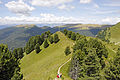
The Pitschberg is known for its panorama, from the top of the mountain you can see most of the Val Gardena Dolomites.

Summit cross on the Cansla dla Ciarità on the Pitschberg. Wooden sculpture by Harald Schmalzl 1993
Cansla dla Ciarità , northern extension of the Pitschberg

Eastern slope with the Sas de Pic on the left and Crujëtes on the right


Web links
Individual evidence
- ↑ Reimo Lunz: Archaeological grazing lights from Val Gardena . In: Archaeological forays through South Tyrol . Athesia, Bozen 2004, ISBN 8882662586 , p. 332
- ↑ Gretl Senoner: Unita didatica per l nseniament tla scola mesana . Istitut Pedagogich Ladin, Bozen 2002, ISBN 88-86137-60-5
- ^ Josef Kostner , Gilo Prugger: Planta danter i ruves de Cuecenes y Ncisles. Calënder de Gherdëina 1967, Union di Ladins, St. Ulrich 1966, p. 93.