Seceda
| Seceda | ||
|---|---|---|
|
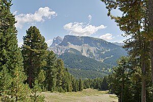
View from the west to the Seceda; on the left in the background Sass Rigais and Furchetta |
||
| height | 2519 m slm | |
| location | South Tyrol , Italy | |
| Mountains | Geisler Group , Dolomites | |
| Dominance | 1 km → Rote Wand | |
| Notch height | 72 m ↓ Panascharte | |
| Coordinates | 46 ° 36 '2 " N , 11 ° 43' 37" E | |
|
|
||
| Development | Cable car | |
The Seceda ( Ladin Secëda , Italian Secèda ) is a 2519 m slm high mountain in South Tyrol .
Location and surroundings
The mountain that borders the Val Gardena valley to the north lies in the Geisler group in the Dolomites . About the summit, the municipal boundary between runs Ortisei , Santa Cristina and Funes . To the north and west, the Seceda borders on Raschötz , to the east on the Geisler peaks, in the southeast the Seceda merges into the Mastlè-Alm . The Pitschberg is located south of the Seceda .
The mountain has steep, brittle slopes to the north and west, which are part of the Puez-Geisler Nature Park . Towards the southeast, the Seceda has the character of a gently sloping alpine pasture . The mountain station of the cable car ( 2453 m ) and a mountain restaurant are in the immediate vicinity of the summit .
Origin of name
The name of the mountain is derived from the Latin word siccus (dry). It refers to the arid and dry pastureland below the summit.
Toponomics
See the map of the Ladin names in the area.
Sports
The Seceda-Alm is used as a ski area in winter (altitudes from 2,500 m to 1,200 m). a. Slopes to Ortisei (10.5 km) and St. Christina (6 km). The area is part of the Seceda-Col Raiser-Raschötz ski carousel. A highlight of the annual ski season is the Gardenissima , the longest giant slalom race in the world. The start is next to the top of the Seceda. One of the longest ski runs in the Dolomites, called La Longia (8.8 km), leads from the Seceda hill (2500 m) to Ortisei (1300 m). In summer the Seceda is a hiking area. A rather difficult path leads over the Pana-Scharte towards the north to the Brogles-Alm with the Brogleshütte .
Cable car
Web links
Individual evidence
- ^ A b Egon Kühebacher: The place names of South Tyrol and their history. The names of the mountain ranges, groups of peaks and individual peaks in South Tyrol . tape 3 . Athesia, Bozen 2000, ISBN 88-8266-018-4 , p. 279 .
- ^ Ernst Eugen Stiebritz: Alpine Club Guide Dolomites - Geisler and Stevia Group . Bergverlag Rudolf Rother, Munich 1981, ISBN 3-7633-1304-4 .
- ^ Josef Kostner , Gilo Prugger: Planta danter i ruves de Cuecenes y Ncisles. Calënder de Gherdëina 1967, Union di Ladins, St. Ulrich 1966, p. 93.
- ↑ Welcome to the Seceda ski area
- ↑ tecneum.eu


