
Rasciesa

Raschötz ( Ladin Resciesa , Italian Rasciesa ) is a mountain range of the western Geisler group ( South Tyrolean Dolomites ) between the Val Gardena and the Villnöss valley . The south-west inclined summit plateau, which supports a spacious high alpine pasture with an area of about 970 hectares, as well as the Raschötzer Forest below are located in the municipality of Ortisei in Val Gardena ; the flanks, which drop more steeply to the north and west, belong to Villnöß and Laion .
Geologically, the mountain formation consists almost exclusively of the so-called Bozen porphyry .
Raschötz, often also called the Raschötz or (more rarely) the Raschötz , is roughly divided into two parts: Innerraschötz in the east and Ausserraschötz in the west. The alpine pasture area is largely left in its natural state, a centuries-old cultural landscape with extensive grassland pastures characterizes its image. Numerous alpine hiking trails run through the Alm and connect it, for example, with the Secedaalm and the nearby villages. The Raschötz-Alm and a large part of the Raschötz Forest belong to the Puez-Geisler Nature Park .
Location and access

Rasciesa is the ridge above the Val Gardena near Ortisei in the south and the Villnöss valley in the north. To the west, the ridge falls in the direction of Laion and the Eisack valley ( Ausserraschötz , 2282 meters above sea level). Towards the east it ends ( Innerraschötz , 2303 meters) at the Brogles-Sattel, to which the Brogles-Alm and Brogleshütte adjoin, and at the Geisler peaks.
Up until 2009, Rasciesa was accessible from Ortisei with a chair lift, built between 1951 and 1952 by Luis Trenker and engineer Leo Demetz. The new Raschötzer Bahn funicular , built in 2009-2010 on the same route, went into operation on September 17, 2010.
The Alm can be reached on foot from Ortisei via a forest path, which is lined by 14 wood-carved stations, copies of Vinzenz Moroder-Resciesa. From the Furnes station (middle station of the Seceda cable car) you can reach Raschötz via the hiking trail on the Cuecenes torrent , Grialëces and via Schienboden near the Broglesalm. From St. Peter bei Lajen you can reach the chapel via the Tschani-Alm hiking trail . The Raschötz can be reached from Villnöß via the Flitzer Scharte or the St. Peter-Scharte in Innerraschötz.
At the highest point of the Ausserraschötz a new summit cross with a body, carved by Josef Bernardi, was erected.
history
The Raschötzer forest area was part of the attested already in the late 10th century Gardena game ban , which in the years 993 / 94-1005 in a traditional note of the Bishopric of Freising by the Bavarian Count Otto of the family of Rapotonen to Bishop Gottschalk of Freising as "ad Gredine forestum ”was transferred.
On February 7, 1416, the Lords of Selva sold the Raschötz-Alm to the court of Gufidaun.
buildings
The following buildings stand on Raschötz: The Holy Cross Chapel on the western edge above St. Peter near Lajen from 1752 (at 2199 m above sea level), the Raschötzhütte , a refuge built in 1903 by the DÖAV section Val Gardena, rebuilt and opened in 2010, the inn and the mountain station the web which Schwaige the shepherd (Cason Schwaige) and a stone construction of the type Nuraghe the Gardena artist Livio Comploi.
Name interpretation
As is often the case with Ladin place names, it is very difficult to interpret. Raschötz was owned by the bishops of Freising until 1416 , when they were acquired by the Counts of Wolkenstein , so Raschötz or Resciesa should come from res ecclesiae = property of the church. In old documents you can find the name Rasetz like Roß-Etz , the horse pasture. Further interpretations come from Raseni = the Raetians who populated the area, and finally recessus = Latin remote, remote place .

Toponomics
See the map of the Ladin names in the area.
The Rasciesa Forest
Below the tree line , the Alm merges over a Krummholz belt ( mountain pine ) into the approx. 894 hectare large Raschötzer Forest . To the south it borders in Ortisei on the farms Resciesa, Cudan, Juaut, Dumat, Nevel and La Pates in the Ausserwinkel , further east in the Oberwinkel on the farms Bataian, Coi, Luca, la Mauta, Rainelles, Runcata, Kuenz, Carai, Puntëdla and Nudrëi.
Picture gallery
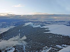
Raschötz from Secëdaberg
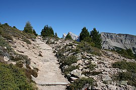
Hiking trail on the Raschötzalm
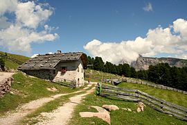
Casonschwaige
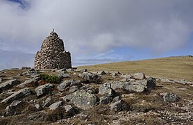
Stone construction by the Val Gardena artist Livio Comploi on the Plan de Corda

Rasciesa Cross


literature
- CM (Christian Moroder): Resciesa . Calënder de Gherdëina 1960, Union di Ladins de Gherdëina, Ortisei in Val Gardena 1959. pp. 32–60. Ladin.
Web links
- On the topography of the Raschötzeralm: Franz Moroder: Sauri da se tenì a-mënz (Inuemes de lues sun Resciesa y Vaves) . Calënder de Gherdëina 1914, p. 72.
- Tour description and pictures Rasciesa
Individual evidence
- ↑ Gianluca Cotza: Geological and geotechnical conditions of mass movements near Pontives (Grödnertal, South Tyrol). Diploma thesis University of Vienna, 2009 (PDF; 11 MB)
- ↑ KOMPASS hiking map ISBN 3-87051-066-8
- ^ Egon Vinatzer: Resciesa à inò si crist. Calënder de Gherdëina 2002. Union di Ladins de Gherdeina. Ortisei in Val Gardena 2001. pp. 194–195 (Ladin)
- ↑ Martin Bitschnau , Hannes Obermair : Tiroler Urkundenbuch, II. Department: The documents on the history of the Inn, Eisack and Pustertal valleys. Vol. 1: Up to the year 1140 . Universitätsverlag Wagner, Innsbruck 2009, ISBN 978-3-7030-0469-8 , p. 135-137, No. 170 .
- ↑ Toni Sotriffer: L Crist y la Capela de Resciesa. La Usc di Ladins , Ortisei in Val Gardena, No. 35/2012, p. 16 (Ladin)
- ^ ( Josef Kostner ): Planta de Resciesa. Calënder de Gherdëina 1960, Union di Ladins, St. Ulrich 1959, p. 111.
Coordinates: 46 ° 36 ′ 1 ″ N , 11 ° 39 ′ 44 ″ E