
Lint de Grialëces
| Lint de Grialëces | ||
 Course in the stone pine forest |
||
| Data | ||
| location | South Tyrol , Italy | |
| River system | Etsch | |
| Drain over | Annabach → Grödner Bach → Eisack → Etsch → Adriatic Sea | |
| source | Rail bottom of your de Bredles 46 ° 36 '36 " N , 11 ° 43' 10" O |
|
| Source height | approx. 2120 m slm | |
| muzzle | Cuecenes-Bach coordinates: 46 ° 36 ′ 0 ″ N , 11 ° 42 ′ 24 ″ E 46 ° 36 ′ 0 ″ N , 11 ° 42 ′ 24 ″ E |
|
| Mouth height | 1823 m | |
| Height difference | approx. 297 m | |
The Lint de Grialëces is a mountain stream in the Puez-Geisler Nature Park .
It arises from three springs on the Schienboden and at the Eures de Bredles in the Innerraschötz at an altitude of 2,200 m. The entire course is in uninhabited area, consisting of pasture and predominantly stone pine and spruce forest . Geologically, the river bed in Val Gardena is sandstone and porphyry .
As early as the 2nd half of the 19th century, the course was built with 13 weirs from the abundant porphystone blocks. Part of the construction also consists of a lateral protective wall made of tree trunks. The torrent flows into the Ruf de Cuecenes stream near the remains of an old lime kiln, called Ciaucëia in Ladin . The Cuecenes brook finally flows into the Annabach, a tributary of the Gardena brook .

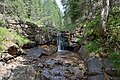
Upper course on the Val Gardena sandstone layers
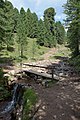
Path to the Brogles Alm

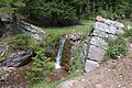

Mouth in the Ruf de Cuecenes


literature
- Frieda Piazza. Ruf de Grialëces from Calender de Gherdeina 1994 , Union di Ladins de Gherdëina (ed.) 1993. p. 143
- Anonymous (Josef Kostner): Planta de Resciesa . Calënder de Gherdëina 1960, Union di Ladins, St. Ulrich 1959, p. 111.