
Mastlé


Mastlé is the Ladin name for the Alm in Val Gardena in South Tyrol, also known in German as Aschgler Alm .
Location and surroundings
The pasture is located in the municipality of St. Christina in Val Gardena and is bordered to the north by the Secëda and the Geisler peaks , in the east Mastlé meets the Cisles-Alm , the southern border is formed by the Col Raiser hill and the Pitschberg .
Smaller areas on the edge of the Alm are part of the Puez-Geisler Nature Park . With the Secëda and the Col Raiser, the Alm is a well-known ski area in winter. Most of the alpine meadows are mowed in summer, in contrast to the more stony neighboring Cisles Alm, which is used exclusively as a pasture area.
Natural monuments
Five of the natural monuments of the municipality of St. Christina are located on the Alm .
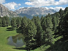
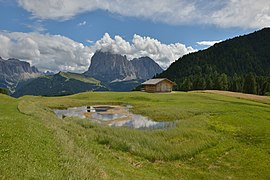
Mountain lakes and streams
The Alm is also characterized by numerous small mountain lakes from the Würm glacial period . The lakes are given by their Ladin name.
There are a total of nine: Lech da Iman , Lech da Rijeda , Lech Sant , Poza Zentrina or Lech de Trëbe , Lech da Pertan , Lech dla Scaies or Lech dala Scaia , Lech dl Pitl Vedl , Lech Fosch , Lech dl grand Iacun , Lech dl Mandl .

The Lech da Iman , the highest of these lakes.

The Lech da Rijeda , natural monument.

The Lech Sant , natural monument.
The Poza Zentrina , natural monument.

The Lech dl Pitl Vedl .

The Lech da Pertan

The Lech dl grand Iacun .
The Lech dl Mandl , natural monument.

The Lech dla Scaies or Lech dala Scaia .


The most important brook is the Ruf de Mastlè , which flows into the Cislesbach and thus ultimately into the Gardena Brook .
building
In 1969 a mountain chapel dedicated to the prophet Elias was built on the mountain pasture. Numerous mountain huts serve the lively summer and winter tourism.
See also
literature
- Chemun de Santa Cristina - Cherta topografica. Cherta ortofoto cun i toponims ladins. Published by Istitut Ladin Micurà de Rü, Cunsei de furmazion de Santa Cristina, 2005, ISBN 88-8171-064-1 .
Web links
Individual evidence
- ^ Josef Kostner , Gilo Prugger: Planta danter i ruves de Cuecenes y Ncisles. Calënder de Gherdëina 1967, Union di Ladins, St. Ulrich 1966, p. 93.
- ^ FM (Friedrich Moroder): La Nueva Capela de Fermeda sun Mastlé. Calënder de Gherdëina 1970, Union di Ladins, St. Ulrich 1969, p. 34.
Coordinates: 46 ° 35 ′ 32.2 " N , 11 ° 44 ′ 8.1" E