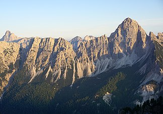
Bosconero group
| Bosconero group | |
|---|---|
| Highest peak | Sasso di Bosconero ( 2468 m slm ) |
| location | Belluno Province , Italy |
| part of | Dolomites |
| Coordinates | 46 ° 20 ′ N , 12 ° 16 ′ E |
The Bosconerogruppe - Italian Gruppo del Bosconero / German about Black Forest - is a mountain group of the Dolomites .
It is located south of Cortina and is most easily reached via the Passo Cibiana . The Piave Valley passes in the east and the Val di Zoldo with the main town Forno di Zoldo lies in the southwest and west . The Dolomites high path No. 3 crosses the mountain range.
summit
The highest peak is the Sasso di Bosconero ( 2468 m slm ). Other peaks:
- Sassolungo di Cibiana , 2413 m slm
- Torre Campestrin , 2241 m slm
- Sfornioi , 2425 m slm
- Sasso di Toanella , 2430 m slm
- Rocchetta Alta di Bosconero , 2412 m slm
Huts
In the Bosconero group there is only one refuge and two bivouac boxes , Casera Campestrin and O. Tovanella, the Rifugio Casera di Bosconero .
swell
Christiane Nastarowitz-Bien: Page no longer available , search in web archives: Bosconero - Romance and rugged Dolomite cliffs for the adventurous - tour tips, maps, pictures (PDF)
Web links
- Ascensión al Sasso di Bosconero - Youtube video with views of the Sasso di Bosconero

